North Carolina Police Receive Sky Arrow LSA | Aero-News Network
Aero-News Network
RSS icon RSS feed
podcast icon MP3 podcast
Subscribe Aero-News e-mail Newsletter Subscribe

Airborne Unlimited -- Most Recent Daily Episodes

Episode Date

Airborne-Monday

Airborne-Tuesday

Airborne-Wednesday Airborne-Thursday

Airborne-Friday

Airborne On YouTube

Airborne-Unlimited-04.01.24

Airborne-Unlimited-04.09.24

Airborne-Unlimited-04.10.24 Airborne-Unlimited-04.11.24

Airborne-Unlimited-04.12.24

Join Us At 0900ET, Friday, 4/10, for the LIVE Morning Brief.
Watch It LIVE at
www.airborne-live.net

Thu, Mar 12, 2009

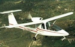
North Carolina Police Receive Sky Arrow LSA

Plane Bought Through DOJ Study On Effectiveness Of Light Planes

North Carolina sheriff's deputies have a new set of eyes in the sky: a Sky Arrow 600 light-sport aircraft.

The Greenboro News-Record reports the long-awaited plane landed at Piedmont Triad International Airport late last week. The aircraft -- purchased through a Department of Justice trial program -- was unveiled Monday, and will soon enter a cooperative program among sheriff's departments in four area counties.

Officials in Guilford, Alamance, Davidson and Randolph counties will use the plane for a variety of roles... including surveillance for possible drug fields, searching for missing people, and routine patrol duties.

"A lot of departments like ours can't justify buying a plane and putting a full-time pilot out there," Guilford County Sheriff BJ Barnes said. "(The partnership) will allow us to do the things we need to do without the expense that goes with it."

The Sky Arrow's reported $85,000 pricetag was paid for through a study by National Institute of Justice, measuring the effectiveness of LSAs in law enforecement roles. All maintenance and fuel costs will be paid through funds recovered in drug busts.

In particular, the study aims to show light sport aircraft can perform traditional aerial law enforcement roles more efficiently than existing fixed-wing planes, which local sheriff's departments had to share with the state.

"We had to do it on their time. If it rained that particular day or for whatever reason, they weren't able to go up, we weren't able to fly," Barnes said. "This is going to enable us to fly when we need to fly and for whatever mission we have."

The low-and-slow Sky Arrow is well-suited for a number of those duties, said Alamance County Sheriff Terry Johnson. The faster response time will be welcomed by local officials.

"By using this particular airplane, you can also cut down for manpower used for surveillance, and the chances of getting burned by the suspect is a whole lot less," Johnson added.

Each sortie will be flown by one of three pilots checked out in the plane, all from the Guilford County Sheriff's Office. The rear seat of the two-place aircraft will be occupied by an official with whatever agency has commissioned the plane for that mission.

FMI: www.ojp.usdoj.gov/nij, www.guilfordcountysheriff.com

Advertisement

More News

ANN's Daily Aero-Linx (04.13.24)

Aero Linx: Florida Antique Biplane Association "Biplanes.....outrageous fun since 1903." That quote really defines what the Florida Antique Biplane Association (FABA) is all about.>[...]

ANN's Daily Aero-Term (04.13.24): Beyond Visual Line Of Sight (BVLOS)

Beyond Visual Line Of Sight (BVLOS) The operation of a UAS beyond the visual capability of the flight crew members (i.e., remote pilot in command [RPIC], the person manipulating th>[...]

Airborne 04.09.24: SnF24!, Piper-DeltaHawk!, Fisher Update, Junkers

Also: ForeFlight Upgrades, Cicare USA, Vittorazi Engines, EarthX We have a number of late-breaking news highlights from the 2024 Innovation Preview... which was PACKED with real ne>[...]

Aero-News: Quote of the Day (04.14.24)

“For Montaer Aircraft it is a very prudent move to incorporate such reliable institution as Ocala Aviation, with the background of decades in training experience and aviation>[...]

ANN's Daily Aero-Term (04.14.24): Maximum Authorized Altitude

Maximum Authorized Altitude A published altitude representing the maximum usable altitude or flight level for an airspace structure or route segment. It is the highest altitude on >[...]

blog comments powered by Disqus


Advertisement

Advertisement

Podcasts

Advertisement

© 2007 - 2024 Web Development & Design by Pauli Systems, LC