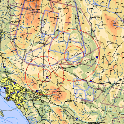
 NOTAM Number: FDC 7/7044
Issue Date: April 02, 2007 at 1541 UTC
Location: Victorville/Fort Irwin, California
Beginning Date and Time: April 04, 2007 at 1755 UTC
Ending Date and Time: April 04, 2007 at 2325 UTC
Reason for NOTAM: Temporary flight restrictions for VIP (Very
Important Person) Movement
Type: VIP
Replaced NOTAM(s): 7/6947: change in emergency medical contact
phone number.
Affected Area(s)
Area A
Airspace Definition:
Center: 0.6 nautical miles from VICTORVILLE VOR/DME(VCV)
on the 102 radial (Latitude: 34º35'24"N, Longitude:
117º22'47"W)
Radius: 30 nautical miles
Altitude: From the surface up to but not including
FL(180)
Effective Date(s):
From April 04, 2007 at 1755 UTC (April 04, 2007 at 1055
PDT)
To April 04, 2007 at 1900 UTC (April 04, 2007 at 1200
PDT)
Area B
Airspace Definition:
Center: 0.6 nautical miles from VICTORVILLE VOR/DME(VCV)
on the 102 radial (Latitude: 34º35'24"N, Longitude:
117º22'47"W)
Radius: 10 nautical miles
Altitude: From the surface up to but not including
FL(180)
Effective Date(s):
From April 04, 2007 at 1755 UTC (April 04, 2007 at 1055
PDT)
To April 04, 2007 at 1900 UTC (April 04, 2007 at 1200
PDT)
Area C
Airspace Definition:
Center: 19 nautical miles from DAGGETT VORTAC(DAG) on the 335
radial (Latitude: 35º16'32"N, Longitude:
116º38'32"W)
Radius: 40 nautical miles
Altitude: From the surface up to but not including
FL(180)
Effective Date(s):
From April 04, 2007 at 1835 UTC (April 04, 2007 at 1135
PDT)
To April 04, 2007 at 2245 UTC (April 04, 2007 at 1545
PDT)
Area D
Airspace Definition:
Center: 19 nautical miles from DAGGETT VORTAC(DAG) on
the 335 radial (Latitude: 35º16'32"N, Longitude:
116º38'32"W)
Radius: 15 nautical miles
Altitude: From the surface up to but not including
FL(180)
Effective Date(s):
From April 04, 2007 at 1835 UTC (April 04, 2007 at 1135
PDT)
To April 04, 2007 at 2245 UTC (April 04, 2007 at 1545
PDT)
Area E
Airspace Definition:
Center: 0.6 nautical miles from VICTORVILLE VOR/DME(VCV) on
the 102 radial (Latitude: 34º35'24"N, Longitude:
117º22'47"W)
Radius: 30 nautical miles
Altitude: From the surface up to but not including
FL(180)
Effective Date(s):
From April 04, 2007 at 2220 UTC (April 04, 2007 at 1520
PDT)
To April 04, 2007 at 2325 UTC (April 04, 2007 at 1625
PDT)
Area F
Airspace Definition:
Center: 0.6 nautical miles from VICTORVILLE VOR/DME(VCV) on
the 102 radial (Latitude: 34º35'24"N, Longitude:
117º22'47"W)
Radius: 10 nautical miles
Altitude: From the surface up to but not including
FL(180)
Effective Date(s):
From April 04, 2007 at 2220 UTC (April 04, 2007 at 1520
PDT)
To April 04, 2007 at 2325 UTC (April 04, 2007 at 1625
PDT)

Operating Restrictions and Requirements
No pilots may operate an aircraft in the areas covered by this
NOTAM (except as described).
Except as specified below and/or unless authorized by the air
traffic security coordinator via the Domestic Events Network
(DEN):
A. All aircraft operations within the 10 NMR and/or 15 NMR areas
listed above are prohibited except for:
Approved law enforcement, military aircraft directly supporting
the United States Secret Service (USSS) and the Office of the
President of the United States, approved emergency medical flights,
and regularly scheduled commercial passenger and all-cargo carriers
operating under one of the following TSA-Approved standard security
programs/procedures: aircraft operator standard security program
(AOSSP), domestic security integration program (DSIP), twelve five
standard security program (TFSSP) all cargo, or all-cargo
international security procedure (ACISP) and are arriving into
and/or departing from 14 CFR part 139 airports.
For operations within the TFR, all emergency/life saving flight
(medical/law enforcement/firefighting) operations must coordinate
in advance with the USSS at 253-982-4393 to avoid potential
delays.
B. Within the airspace between 10 NMR and 30 NMR and/or the
airspace between 15 NMR and 40 NMR listed above:
All aircraft entering or exiting the 30/40 NM radius TFR must be
on an active IFR or VFR flight plan with a discrete code assigned
by an Air Traffic Control (ATC) facility. Aircraft must be
squawking the discrete code prior to departure and at all times
while in the TFR.
All aircraft entering or exiting the 30/40 NM radius TFR must
remain in two-way radio communications with ATC.
All aircraft operating within the 10 to 30 NM radius TFR and/or
the 15 to 40 NM radius TFR and operating at altitudes of up to but
not including FL180 are limited to aircraft arriving or departing
local airfields and ATC may authorize transit operations. Aircraft
may not loiter.
Flight training, practice instrument approaches, aerobatic
flight, glider operations, parachute operations, ultralight, hang
gliding, balloon operations, agriculture/crop dusting, animal
population control flight operations, and banner towing operations
are not authorized.
All USSS cleared aircraft operators based in the area should
notify the USSS prior to their departure.
For operations within the TFR, all emergency/life saving flight
(medical/law enforcement/firefighting) operations must coordinate
in advance with the USSS at 253-982-4393 to avoid potential
delays.
C. FAA recommends that all aircraft operators check NOTAMS
frequently for possible changes to this TFR prior to operations
within this region.
Other Information:
ARTCC: ZLA - Los Angeles Center
Authority: Title 14 CFR section 91.141
FMI: www.tfr.faa.gov,
Depicted TFR data may not be a complete listing. Pilots should not
use the information on this website for flight planning purposes.
For the latest information, call your local Flight Service Station
at 1-800-WX-BRIEF.
 ANN's Daily Aero-Term (04.14.24): Maximum Authorized Altitude
 ANN's Daily Aero-Linx (04.14.24)
 Classic Aero-TV: 'We're Surviving'-- Kyle Franklin Describes Airshow Life 2013
 Aero-News: Quote of the Day (04.14.24)
 Airborne 04.09.24: SnF24!, Piper-DeltaHawk!, Fisher Update, Junkers


