Software Helps Plan Missions Using Elevation, Satellite, Threat
Data
By ANN Correspondent Juan Jiménez, at Heli Expo
2003
 Twenty
years ago, at Hughes Radar System Group's facility in El Segundo
(CA), this ANN reporter was assigned to work on what was then a
very experimental, exciting and promising project. One of the
scientists working for the company had developed a computer whose
input was terrain elevation data for the city of Los Angeles. My
task was to write software that would instruct the computer to
"fly" through the terrain. The computer would interpret the
commands I sent it and display the moving terrain. The display was
barely recognizable -- in fact, the only way to tell that you were
seeing moving terrain was to know that that is what it was supposed
to show!
Twenty
years ago, at Hughes Radar System Group's facility in El Segundo
(CA), this ANN reporter was assigned to work on what was then a
very experimental, exciting and promising project. One of the
scientists working for the company had developed a computer whose
input was terrain elevation data for the city of Los Angeles. My
task was to write software that would instruct the computer to
"fly" through the terrain. The computer would interpret the
commands I sent it and display the moving terrain. The display was
barely recognizable -- in fact, the only way to tell that you were
seeing moving terrain was to know that that is what it was supposed
to show!
The interface software that was my responsibility was finished
on time, and a demonstration was scheduled to show a number of
military officers what we had accomplished. It was a good thing
that these folks had a good imagination, because the screen did not
look anything like Los Angeles. Twenty years later, the state of
the art in this technology is significantly higher.
 CS
Information Systems' Virtual Reality department, based out of
Toulouse, France, has refined the art of terrain visualization and
developed a software package called "Virtual Geo" which allows you
to do the same thing we did twenty years ago. This time, though,
the screen shows exactly what you should see, in spectacular color
and detail.
CS
Information Systems' Virtual Reality department, based out of
Toulouse, France, has refined the art of terrain visualization and
developed a software package called "Virtual Geo" which allows you
to do the same thing we did twenty years ago. This time, though,
the screen shows exactly what you should see, in spectacular color
and detail.
The base package, priced at €3,000 (approx. US$3,000),
makes it possible to visualize and "fly" massive textured terrain
databases combined with satellite or raster images. The rendering
of the data is extremely detailed and includes all the features
that a satellite image can show, including vegetation and detailed
terrain features. In addition, the database can include data for
structures, such as bridges, buildings, entire towns or other
significant features that you want to visualize with the
software.
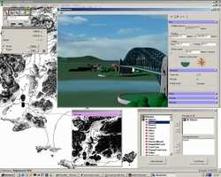 Optional plug-ins can do things such as render
threats such as the radar coverage area at an enemy missile site.
In fact, the French Air Force has bought the entire package of base
software and all plug-ins, worth some €16,000, to plan their
helicopter training missions. The result is that French pilots can
"fly" their entire mission from a PC before they so much as set
foot on a flight line, and "see" what they will be facing during
the mission.
Optional plug-ins can do things such as render
threats such as the radar coverage area at an enemy missile site.
In fact, the French Air Force has bought the entire package of base
software and all plug-ins, worth some €16,000, to plan their
helicopter training missions. The result is that French pilots can
"fly" their entire mission from a PC before they so much as set
foot on a flight line, and "see" what they will be facing during
the mission.
Other applications include national and regional infrastructure
development (urban planning, highways, powerlines and such),
telecommunications (planning for GSM coverage zones), theatre of
conflict simulations and air route definitions. That last
capability is being used by some airlines to allow their pilots to
clearly and accurately visualize the approaches into unfamiliar
airports, without having to fire up an expensive simulator.
What is most surprising about the application is its reasonable
list of minimum hardware requirements: a Pentium III or Athlon 800+
mhz processor, 256 megabytes of RAM, 10 gigabytes of free hard disk
space, an Open-GL compatible accelerated video card such as the
GEForce 2, and either Windows NT version 4 or Windows 2000.
 ANN's Daily Aero-Term (04.20.24): Light Gun

