Fri, Dec 10, 2004
GeoVantage Provided High-Rez Digital Aerial Photography of
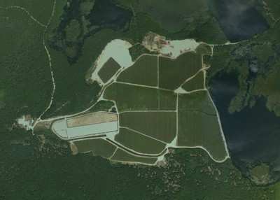
Ocean Spray Cranberry Bogs
 Ocean Spray’s cranberry
harvesting season drew to a close last month, made easier this year
with the use of GeoVantage’s high-resolution aerial imagery.
GeoVantage imaged cranberry bogs in two of Ocean Spray’s
major growing areas in Massachusetts and Quebec.
Ocean Spray’s cranberry
harvesting season drew to a close last month, made easier this year
with the use of GeoVantage’s high-resolution aerial imagery.
GeoVantage imaged cranberry bogs in two of Ocean Spray’s
major growing areas in Massachusetts and Quebec.
Ocean Spray has been implementing aerial photography since 1986.
They made the switch to digital imagery from conventional
film-based photos in 2002, when they selected GeoVantage as their
primary digital aerial imagery provider.

“We chose GeoVantage because of the quality of their imagery
product, and the competitive price that came along with it,”
explains Lyn DiBiase, Principal GIS Analyst at Ocean Spray,
“Our growing areas are located across the U.S. and Canada,
from New Jersey to British Columbia – GeoVantage’s
technology uniquely positions them to comprehensively deliver
imagery of any location. This makes my job that much easier because
I can work with a single provider for all my imagery and receive
consistent, high quality work.”
GeoVantage collects full color and near infrared digital imagery
simultaneously by implementing a fully digital workflow and a
multispectral camera system that is integrated with a global
positioning system (GPS) and inertial measurement unit (IMU). The
process enables imagery to be precisely georegistered and
orthorectified. GeoVantage’s systems are compact and
portable, which means they can be deployed rapidly anywhere in the
world and mounted on local aircraft for image capture.
DiBiase uses the resulting imagery in several ways. Imagery is
used to help on the business end – to map the land Ocean
Spray has under contract with growers who own the cooperative. By
determining the number of acres in production, Ocean Spray can
estimate the number of barrels growers will deliver in a harvest
and make business projections.
DiBiase also provides the imagery to individual growers to help
in their land management. The imagery can reveal drainage problems,
weed and insect infestation and when it may be time to renovate
certain areas. “Helping growers to better interpret and
utilize imagery data is one of my priorities. More and more, we can
apply new technologies to help improve and fine-tune our
production. The switch to digital imagery from film-based alone has
made my work more time-effective and accurate, reducing the chance
for operator error.”
More News
Also: B-29 Superfortress Reunion, FAA Wants Controllers, Spirit Airlines Pulls Back, Gogo Galileo Van's Aircraft posted a short video recapping the goings-on around their reorganiz>[...]
Light Gun A handheld directional light signaling device which emits a brilliant narrow beam of white, green, or red light as selected by the tower controller. The color and type of>[...]
"The journey to this achievement started nearly a decade ago when a freshly commissioned Gentry, driven by a fascination with new technologies and a desire to contribute significan>[...]
"Our driven and innovative team of military and civilian Airmen delivers combat power daily, ensuring our nation is ready today and tomorrow." Source: General Duke Richardson, AFMC>[...]
Aircraft Conflict Predicted conflict, within EDST of two aircraft, or between aircraft and airspace. A Red alert is used for conflicts when the predicted minimum separation is 5 na>[...]
 Airborne 04.16.24: RV Update, Affordable Flying Expo, Diamond Lil

