Enables Real-Time, Offline Mapping For Immediate In-Field Analysis
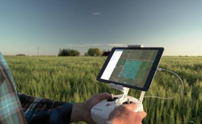
Commercial cloud software developer DroneDeploy has released a beta version of its new Fieldscanner product offering real-time drone mapping, just in time for the spring growing season. With Fieldscanner, available as part of DroneDeploy's iOS app, farmers can use any DJI drone to create a map of their fields as the drone flies so that they can view insights before it lands.
"Growers have been asking for real-time, in-field mapping for a long time, and we're excited to be the first company to deliver a solution," said Mike Winn, CEO of DroneDeploy.
Changes happen fast during the growing season so having timely information to spot and address problems is key. Aerial imagery helps growers detect variability that large fields and tall crops make difficult to see from the ground, but conventional methods are often too slow. Where growers might wait days for airplane or satellite imagery, or spend hours uploading and processing a typical drone map, Fieldscanner can capture a field map in minutes so that growers can make crop management decisions on the spot or use the Fieldscan as a guide for more targeted boots-on-the-ground inspection.
"Real-time data directly from your drone right to the tailgate of your truck while the drone is inflight -- it's so easy, anyone can use it," said Chad Colby, General Manager at Central Illinois Ag, who helped test Fieldscanner before release. "Testing this product, I knew this was a game-changer. Fieldscanner just made a drone the ultimate scouting tool."
Drone maps have already helped many growers improve efficiency, decrease costs and increase yields. With the ability to provide an instant, on-demand view of their fields, Fieldscanner promises to have an even bigger impact by helping growers:
- Spot weeds and pests for timely, efficient pesticide application
- Detect plant stress to inform nutrient application and monitor results
- Evaluate crop damage from weather events
- And monitor dry-down and decide when to harvest to maximize yields.
"DroneDeploy has continuously pushed DJI's aerial platforms to become part of the standard enterprise toolkit," said Jan Gasparic, Head of Enterprise Marketing. "Developed based on DJI's software development kit, the DroneDeploy Fieldscanner software has the ability to provide instant, insightful and accurate data for better business decision making. This will also help enterprises save money, time and expand the use of UAVs across various commercial applications."
Poor connectivity and slow internet speeds have long challenged adoption of drone mapping in remote rural areas. Built for use in the field, Fieldscanner can operate entirely offline, with no need for cellular or data coverage.
Fieldscanner uses DroneDeploy's existing automatic flight planning for DJI drones and adds local processing on the drone and mobile device to create a low-resolution Fieldscan as the drone is flying, instead of requiring the user to process imagery into a map at a computer after the flight. Once the drone lands, the Fieldscan informs crop scouting and helps growers take notes in the field. A grower can use it to spot variability in his fields, see his location as he navigates to specific areas for ground truthing, and (if a data connection is available) pin notes and photos of findings directly to the map. If greater precision is needed, imagery captured during flight can still be uploaded to DroneDeploy to process a regular, high-resolution map and 3D model.
"Time is in short supply on the farm, so when considering a new tool, the faster and easier, the better," said Jim Love, Light Robotics Manager at Beck's Hybrids. "With the ability to capture data in minutes, offline, with just a drone and a phone, Fieldscanner represents the missing link that will transform drones from useful tool, to a must-have for weekly crop scouting."
The Fieldscanner beta is being rolled out to all DroneDeploy customers for use with DJI drones and iOS devices, including customers who purchased drone DroneDeploy from a partner or reseller. Any customers of the Case IH UAV solution and New Holland PLM Drone Data solution sold through CNH Industrial's network dealers in North America will now get access to Fieldscanner at no additional cost.
"For our growers, time is one of the most valuable assets they control," said Joe Michaels, Director of Global Precision Product Management with CNH Industrial. "Fieldscanner allows our customers to save time and improve their efficiency by enabling them to get more information without leaving the field."
The launch of Fieldscanner represents the first big step in real-time mapping for DroneDeploy and for the commercial drone industry as a whole. "This is just the beginning," said Jono Millin, co-founder and Chief Product Officer at DroneDeploy. "We already have exciting new improvements in the works to further unlock the potential of real-time mapping."
(Image provided with DroneDeploy media release)
 ANN's Daily Aero-Linx (04.13.24)

