Mon, Aug 22, 2011
Offers Advanced Flight Planning Option
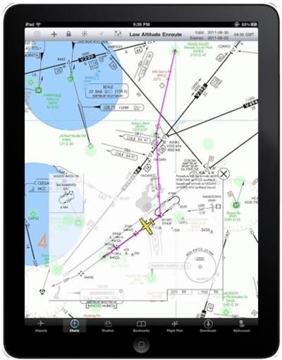
Flight Guide has rolled out its upgraded iEFB v4.0, offering a
brand new Flight Planning option that allows operators to quickly
and easily create a Flight Plan on any of the apps high resolution
Seamless Charts. Using "Your Flight Plan," waypoints can be created
by either typing in an airport identifier or by using the "One
Touch" add, remove and insert waypoint feature. Intersections
and navaids can also be quickly located, or search for nearest
airports to add to the flight plan without ever leaving the chart.
Selecting the "Flight Planner" main menu page allows the user to
reorganize waypoints, auto reverse the flight plan, customize
airplane profiles, file a flight plan and more. Flight Plan out of
view? The one touch "Display Route" icon allows the entire route to
be viewed instantly.
With Flight Guide's "PLUS" plans, Instrument Approaches and/or
Flight Guide Airport Diagrams can be overlaid on the Seamless
Charts in geo-referenced location. Simply zoom in on the desired
airport icon, using Apple’s standard “pan, pinch &
drag” interface and watch as the entire Flight Guide Airport
Diagram comes into view without ever having to leave the chart.
With iEFB’s Moving Map capability, the aircraft’s
geo-referenced location is displayed on both the chart and the
over-laying Flight Guide Airport Diagram. To take it a step
further, a semi-transparent IFR instrument approach,
geo-referenced, can be presented on a Low or High Enroute,
Sectional or WAC chart.
Flight Guide iEFB v4.0 also includes a "Track Up" feature,
allowing users to manually toggle between either "North up" or
"Track Up" depending on the desired display. Charts can be set to
default to "Track Up."
The upgraded version has also added the ability to alert and
display Air Traffic graphically, TCAS-like, using the ZAON PCAS XRX
connected to Flight Guide's FLY-Wi GPS. Traffic shows on Flight
Guide iEFB's Seamless Charts with Moving Map, displaying standard
TCAS I symbols. Flight Guide iEFB will identify the location,
distance, vertical separation and heading of any aircraft within
the traffic system range. Pilots will have immediate situational
awareness of traffic that they can easily track. Flight Guide
iEFB's traffic feature is included in the Flight Guide iEFB v4.0
update and available FREE with all Flight Guide iEFB subscription
data plans.
In addition to annual data plans, monthly data plans are also
available and can be purchased through the Flight Guide iEFB App
itself. Simply download iEFB from the Apple App store onto your
iPad and purchase a monthly plan.
More News
Also: B-29 Superfortress Reunion, FAA Wants Controllers, Spirit Airlines Pulls Back, Gogo Galileo Van's Aircraft posted a short video recapping the goings-on around their reorganiz>[...]
Light Gun A handheld directional light signaling device which emits a brilliant narrow beam of white, green, or red light as selected by the tower controller. The color and type of>[...]
"The journey to this achievement started nearly a decade ago when a freshly commissioned Gentry, driven by a fascination with new technologies and a desire to contribute significan>[...]
"Our driven and innovative team of military and civilian Airmen delivers combat power daily, ensuring our nation is ready today and tomorrow." Source: General Duke Richardson, AFMC>[...]
Aircraft Conflict Predicted conflict, within EDST of two aircraft, or between aircraft and airspace. A Red alert is used for conflicts when the predicted minimum separation is 5 na>[...]
 Airborne 04.16.24: RV Update, Affordable Flying Expo, Diamond Lil

