Navy UAV Down In MD | Aero-News Network
Aero-News Network
RSS icon RSS feed
podcast icon MP3 podcast
Subscribe Aero-News e-mail Newsletter Subscribe

Airborne Unlimited -- Most Recent Daily Episodes

Episode Date

Airborne-Monday

Airborne-Tuesday

Airborne-Wednesday Airborne-Thursday

Airborne-Friday

Airborne On YouTube

Airborne-Unlimited-04.01.24

Airborne-Unlimited-04.16.24

Airborne-FlightTraining-04.17.24 Airborne-Unlimited-04.11.24

Airborne-Unlimited-04.12.24

Join Us At 0900ET, Friday, 4/10, for the LIVE Morning Brief.
Watch It LIVE at
www.airborne-live.net

Tue, Jun 12, 2012

Navy UAV Down In MD

Officials Say Aircraft Was Conducting A Routine Maintenance Flight

A Navy UAV has gone down on the Eastern Shore of Maryland, according to the Navy and the Coast Guard.

Initial reports are that the 44-foot UAV is part of the Navy's Patuxent River Naval Station's Unmanned Aviation and Strike Weapons program. The Associated Press reports that it went down just after noon Monday near Bloodsworth Island. No injuries were reported in connection with the accident.

The blog SeaWaves indicates that the UAV is one of five Global Hawk aircraft that was acquired from the Air Force for the Broad Area Maritime Surveillance Demonstrator program. The BAMS-D program has been working on employing high-altitude unmanned patrol aircraft since November, 2006.

According to the NAVAIR website, The Navy’s RQ-4A Global Hawk UAVs fly up to 60,000 feet. The high-flying aerial vehicle can operate for more than 30 hours above most weather. Imagery and other data obtained by the aircraft feeds by satellite into the Navy ground segment consisting of a mission control element, a launch and recovery element, and a Navy-designed Tactical Auxiliary Ground Station (TAGS). Flown by Navy and Navy contractor pilots, the asset is controlled from Naval Air Station (NAS) Patuxent River, MD.

BAMS-D was used to develop methods for integrating the Automatic Identification System (AIS) into Fleet operations. Experimentation using BAMS-D also benefited the Naval Sea Systems Command Ocean Surveillance Initiative and Oceanographer of the Navy office activities assessing usefulness of long-endurance, high-altitude unmanned systems in collecting Fleet-relevant meteorological data.

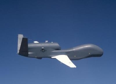
The Coast Guard has set up a safety zone around the marshy area where the aircraft went down in Dorchester County, MD, according to USCG Petty Officer Jonathan Lindberg. (File photo of Navy Global Hawk)

FMI: www.navy.mil, www.uscg.mil

Advertisement

More News

ANN's Daily Aero-Term (04.14.24): Maximum Authorized Altitude

Maximum Authorized Altitude A published altitude representing the maximum usable altitude or flight level for an airspace structure or route segment. It is the highest altitude on >[...]

ANN's Daily Aero-Linx (04.14.24)

Aero Linx: Soaring Safety Foundation (SSF) The Soaring Safety Foundation (SSF) is the Training and Safety arm of the Soaring Society of America (SSA). Our mission is to provide ins>[...]

Classic Aero-TV: 'We're Surviving'-- Kyle Franklin Describes Airshow Life 2013

From 2013 (YouTube Version): Dracula Lives On Through Kyle Franklin... and We're NOT Scared! ANN CEO and Editor-in-Chief, Jim Campbell speaks with Aerobatic and airshow master, Kyl>[...]

Aero-News: Quote of the Day (04.14.24)

“For Montaer Aircraft it is a very prudent move to incorporate such reliable institution as Ocala Aviation, with the background of decades in training experience and aviation>[...]

Airborne 04.09.24: SnF24!, Piper-DeltaHawk!, Fisher Update, Junkers

Also: ForeFlight Upgrades, Cicare USA, Vittorazi Engines, EarthX We have a number of late-breaking news highlights from the 2024 Innovation Preview... which was PACKED with real ne>[...]

blog comments powered by Disqus


Advertisement

Advertisement

Podcasts

Advertisement

© 2007 - 2024 Web Development & Design by Pauli Systems, LC