HAI2009: Honeywell Intro's Sentinel MFD/Nav System To US Market | Aero-News Network
Aero-News Network
RSS icon RSS feed
podcast icon MP3 podcast
Subscribe Aero-News e-mail Newsletter Subscribe

Airborne Unlimited -- Most Recent Daily Episodes

Episode Date

Airborne-Monday

Airborne-Tuesday

Airborne-Wednesday Airborne-Thursday

Airborne-Friday

Airborne On YouTube

Airborne-Unlimited-04.01.24

Airborne-Unlimited-04.09.24

Airborne-Unlimited-04.10.24 Airborne-Unlimited-04.11.24

Airborne-Unlimited-04.12.24

Join Us At 0900ET, Friday, 4/10, for the LIVE Morning Brief.
Watch It LIVE at
www.airborne-live.net

Mon, Feb 23, 2009

HAI2009: Honeywell Intro's Sentinel MFD/Nav System To US Market

Sentinel Now Available in the US for the First Time

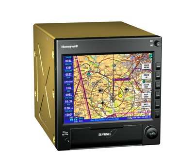
Honeywell's Sentinel helicopter avionics system, used widely by U.K. and European helicopter emergency medical service (HEMS) operators, is now available to pilots in the United States. The system offers critical flight safety information, including high resolution terrain and weather data.

"Honeywell now offers helicopter operators, including HEMS pilots, Sentinel - a single avionics package that provides a multi-function display and navigation system with high resolution mapping, traffic and XM weather, and vertical down track profiling," said Chad Cundiff, Vice President, Crew Interface and Program Management, Honeywell. "Sentinel enhances situational awareness and flight safety."
The suite includes a radar altimeter, above ground level readout, a night vision goggle option and obstacles database.

It provides HEMS operators with a single avionics package to meet FAA guidance. Recent FAA guidance for HEMS operators in the U.S. requires weather, terrain, obstacle and altitude above ground obstacles awareness to be improved, and night vision goggles to be used for night operations.

Paul Whitefield, Chief Pilot at LuviAir, said, "This highly reliable system offers ease of readability of charts, flexibility with data entry via a USB port, the ability to insert flashcards for different map packages, and a very easy, intuitive operation. It is a great system for HEMS operators and the medium and large helicopter segment."

Sentinel entered service with European HEMS and executive operators in 2008 and provides spatial awareness and navigational assistance for urgent mission pilots.

Cundiff said, "With the introduction of XM Weather and Vertical Profile, in addition to U.S. sectionals, terminals and helicopter route charts, Sentinel meets the needs of operators in the U.S. conducting medical rescue operations." The system offers up to 24GB of on-board data storage, allowing Sentinel to provide navigational mapping to high resolution over an entire country. Sentinel is available in several configurations and can operate as a stand-alone, panel mounted MFD/Navigator, remote processor, or as an integrated element of the Honeywell Observer MKIII Mission System.

Sentinel has been priced at $9,000 MSRP for the base unit - an affordable system for U.S. operators. Other user installable upgrades to the Sentinel system are planned for 2009 including Plates and user configurable databases.

FMI: www.honeywell.com

Advertisement

More News

ANN's Daily Aero-Linx (04.13.24)

Aero Linx: Florida Antique Biplane Association "Biplanes.....outrageous fun since 1903." That quote really defines what the Florida Antique Biplane Association (FABA) is all about.>[...]

ANN's Daily Aero-Term (04.13.24): Beyond Visual Line Of Sight (BVLOS)

Beyond Visual Line Of Sight (BVLOS) The operation of a UAS beyond the visual capability of the flight crew members (i.e., remote pilot in command [RPIC], the person manipulating th>[...]

Airborne 04.09.24: SnF24!, Piper-DeltaHawk!, Fisher Update, Junkers

Also: ForeFlight Upgrades, Cicare USA, Vittorazi Engines, EarthX We have a number of late-breaking news highlights from the 2024 Innovation Preview... which was PACKED with real ne>[...]

Aero-News: Quote of the Day (04.14.24)

“For Montaer Aircraft it is a very prudent move to incorporate such reliable institution as Ocala Aviation, with the background of decades in training experience and aviation>[...]

ANN's Daily Aero-Term (04.14.24): Maximum Authorized Altitude

Maximum Authorized Altitude A published altitude representing the maximum usable altitude or flight level for an airspace structure or route segment. It is the highest altitude on >[...]

blog comments powered by Disqus


Advertisement

Advertisement

Podcasts

Advertisement

© 2007 - 2024 Web Development & Design by Pauli Systems, LC