Aspen Avionics Presents 'A New Way' To View Avionics -- Less Expensively! | Aero-News Network
Aero-News Network
RSS icon RSS feed
podcast icon MP3 podcast
Subscribe Aero-News e-mail Newsletter Subscribe

Airborne Unlimited -- Most Recent Daily Episodes

Episode Date

Airborne-Monday

Airborne-Tuesday

Airborne-Wednesday Airborne-Thursday

Airborne-Friday

Airborne On YouTube

Airborne-Unlimited-04.01.24

Airborne-Unlimited-04.09.24

Airborne-Unlimited-04.10.24 Airborne-Unlimited-04.11.24

Airborne-Unlimited-04.12.24

Join Us At 0900ET, Friday, 4/10, for the LIVE Morning Brief.
Watch It LIVE at
www.airborne-live.net

Tue, Apr 03, 2007

Aspen Avionics Presents 'A New Way' To View Avionics -- Less Expensively!

Company Cuts Price Of AT300 Hazard Awareness Display By $1,000

Hot on the heels of the announcement of its new corporate motto -- "A New Way To Look At Avionics" -- at AEA 2007, Albuquerque, NM-based Aspen Avionics told ANN of one way its living up to that creed: by offering its flagship AT300 Hazard Awareness Display for a lower price.

Doug Cayne, Aspen Vice President of Marketing, said effective immediately all AT300s will sport a $1,000 price reduction -- to $2,995 MSRP.

"We’re pleased by the retrofit market’s response to the AT300. Our customers have found this product to be an effective terrain awareness solution," said Doug Cayne, Aspen Vice President of Marketing. "We’re confident that this price reduction will make this important technology accessible to more pilots and aircraft owners."

In addition to featuring the AT300 at the Aspen booth on the exhibit floor at AEA (complete with beer and margaritas!), company cofounder and Vice President of Product Management Peter Lyons also presented a technical training workshop Saturday at AEA, spotlighting the AT300's features and benefits.

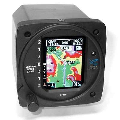
The AT300 is the only color moving map display available in the market that can be directly installed in standard 3 inch instrument hole. This unique capability allows the AT300 to show valuable situational awareness information in the pilot's primary instrument scan, and to do so without the expense or installation complexity associated with traditional Electronic Flight Information Systems (EFIS) or Electronic Horizontal Situation Indicators (EHSI). Because installation of the AT300 requires no panel modifications or equipment relocation, the unit can be installed in virtually any aircraft regardless of the available panel space.

The AT300 moving map display shows the pilot current and next navigation leg information overlaid on a high-resolution terrain and obstacle map. Terrain and obstacle data is color-coded based upon its vertical separation from the aircraft's current altitude (similar to a TAWS display), providing the pilot an intuitive and easy to understand display to help improve their awareness of potential hazards along the current flight route. The AT300 also provides the pilot with a full time display of the aircraft's height above ground -- information which has not previously been readily available in most light aircraft. The AT300 can also be configured by the pilot to display either side profile terrain or a data block showing the active waypoint identifier, desired track, groundspeed, distance to go and estimated time enroute.

Aspen Avionics was founded in 2004 by a team of experienced avionics professionals and aviation enthusiasts.

FMI: www.aspenavionics.com

Advertisement

More News

ANN's Daily Aero-Linx (04.13.24)

Aero Linx: Florida Antique Biplane Association "Biplanes.....outrageous fun since 1903." That quote really defines what the Florida Antique Biplane Association (FABA) is all about.>[...]

ANN's Daily Aero-Term (04.13.24): Beyond Visual Line Of Sight (BVLOS)

Beyond Visual Line Of Sight (BVLOS) The operation of a UAS beyond the visual capability of the flight crew members (i.e., remote pilot in command [RPIC], the person manipulating th>[...]

Airborne 04.09.24: SnF24!, Piper-DeltaHawk!, Fisher Update, Junkers

Also: ForeFlight Upgrades, Cicare USA, Vittorazi Engines, EarthX We have a number of late-breaking news highlights from the 2024 Innovation Preview... which was PACKED with real ne>[...]

Aero-News: Quote of the Day (04.14.24)

“For Montaer Aircraft it is a very prudent move to incorporate such reliable institution as Ocala Aviation, with the background of decades in training experience and aviation>[...]

ANN's Daily Aero-Term (04.14.24): Maximum Authorized Altitude

Maximum Authorized Altitude A published altitude representing the maximum usable altitude or flight level for an airspace structure or route segment. It is the highest altitude on >[...]

blog comments powered by Disqus


Advertisement

Advertisement

Podcasts

Advertisement

© 2007 - 2024 Web Development & Design by Pauli Systems, LC