Newest GOES Weather Satellite Ready For Action | Aero-News Network
Aero-News Network
RSS icon RSS feed
podcast icon MP3 podcast
Subscribe Aero-News e-mail Newsletter Subscribe

Airborne Unlimited -- Most Recent Daily Episodes

Episode Date

Airborne-Monday

Airborne-Tuesday

Airborne-Wednesday Airborne-Thursday

Airborne-Friday

Airborne On YouTube

Airborne-Unlimited-04.01.24

Airborne-Unlimited-04.09.24

Airborne-Unlimited-04.10.24 Airborne-Unlimited-04.11.24

Airborne-Unlimited-04.12.24

Join Us At 0900ET, Friday, 4/10, for the LIVE Morning Brief.
Watch It LIVE at
www.airborne-live.net

Mon, Sep 06, 2010

Newest GOES Weather Satellite Ready For Action

But It Will Sit In A Parking Orbit As A Backup ... For Now

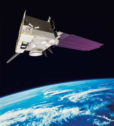
NASA and NOAA's latest Geostationary Operational Environmental Satellite, GOES-15, has successfully completed five months of on-orbit testing and has been accepted into service. The satellite has demonstrated operational readiness of its subsystems, spacecraft instruments and communications services. GOES-15 is the third and final spacecraft in the GOES N-P Series of geostationary environmental weather satellites.


GOES-15 Thermal Images

NOAA operates GOES-13 in the east and GOES-11 in the west -- both provide weather observations covering more than 50 percent of the Earth's surface. The GOES-15 spacecraft, designed and built by Boeing Space and Intelligence Systems, will be placed in an on-orbit storage location at 105 degrees west longitude should one of the operational GOES satellites degrade or exhaust their fuel. It will share a parking space with GOES-14, currently in the same storage orbit. Both satellites can be made operational within 24 hours to replace an older satellite.

The GOES fleet help NOAA forecasters track life-threatening weather and solar activity that can impact the satellite-based electronics and communications industry. During the checkout period, GOES-15 delivered high-resolution images from space, including the first visible and infrared images of Earth taken by its imager instrument, and the first image of the sun taken by its solar X-ray imager instrument.


GOES Satellite NASA Image

"With more than 35 million Americans living in hurricane-prone areas, we need the reliable, accurate data GOES provide," said Gary Davis, director of the Office of Systems Development at NOAA's Satellite and Information Service.

A six-minute view of the 2009 Atlantic hurricane season as seen from space by GOES-12, formerly the East Coast GOES sentinel, is available online. The video highlights NASA technology and NOAA satellite data.

NOAA manages the GOES program, establishes requirements, provides all funding and distributes environmental satellite data for the United States. NASA Goddard procures and manages the design, development and launch of the satellites for NOAA on a cost reimbursable basis.

FMI: www.nasa.gov/goes-p

Advertisement

More News

ANN's Daily Aero-Linx (04.13.24)

Aero Linx: Florida Antique Biplane Association "Biplanes.....outrageous fun since 1903." That quote really defines what the Florida Antique Biplane Association (FABA) is all about.>[...]

ANN's Daily Aero-Term (04.13.24): Beyond Visual Line Of Sight (BVLOS)

Beyond Visual Line Of Sight (BVLOS) The operation of a UAS beyond the visual capability of the flight crew members (i.e., remote pilot in command [RPIC], the person manipulating th>[...]

Airborne 04.09.24: SnF24!, Piper-DeltaHawk!, Fisher Update, Junkers

Also: ForeFlight Upgrades, Cicare USA, Vittorazi Engines, EarthX We have a number of late-breaking news highlights from the 2024 Innovation Preview... which was PACKED with real ne>[...]

Aero-News: Quote of the Day (04.14.24)

“For Montaer Aircraft it is a very prudent move to incorporate such reliable institution as Ocala Aviation, with the background of decades in training experience and aviation>[...]

ANN's Daily Aero-Term (04.14.24): Maximum Authorized Altitude

Maximum Authorized Altitude A published altitude representing the maximum usable altitude or flight level for an airspace structure or route segment. It is the highest altitude on >[...]

blog comments powered by Disqus


Advertisement

Advertisement

Podcasts

Advertisement

© 2007 - 2024 Web Development & Design by Pauli Systems, LC