Sat, Feb 23, 2008
 NOTAM Number: FDC 8/5721
Issue Date: February 22, 2008 at 1731 UTC
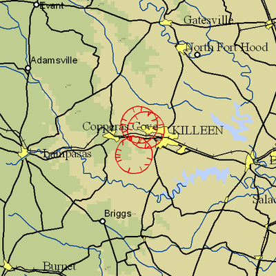
Location: Fort Hood, Texas
Beginning Date and Time: February 26, 2008 at 1355 UTC
Ending Date and Time: February 26, 2008 at 1710 UTC
Reason for NOTAM: Temporary flight restrictions for VIP (Very
Important Person) Movement
Type: VIP
Replaced NOTAM(s): N/A
Affected Area(s)
Area A
Airspace Definition:
Center: On the GRAY VOR/DME (GRK) 333 degree radial at 2.2
nautical miles. (Latitude: 31º04'01"N, Longitude:
97º49'42"W)
Radius: 3 nautical miles
Altitude: From the surface up to but not including 3000 feet
AGL
Effective Date(s):
From February 26, 2008 at 1355 UTC (February 26, 2008 at 0755
CST)
To February 26, 2008 at 1445 UTC (February 26, 2008 at 0845
CST)
Area B
Airspace Definition:
Center: On the GRAY VOR/DME (GRK) 003 degree radial at
6.3 nautical miles. (Latitude: 31º08'09"N, Longitude:
97º47'33"W)
Radius: 3 nautical miles
Altitude: From the surface up to but not including 3000 feet
AGL
Effective Date(s):
From February 26, 2008 at 1415 UTC (February 26, 2008 at 0815
CST)
To February 26, 2008 at 1610 UTC (February 26, 2008 at 1010
CST)
Area C
Airspace Definition:
Center: On the GRAY VOR/DME (GRK) 353 degree radial at 7
nautical miles. (Latitude: 31º08'58"N, Longitude:
97º48'50"W)
Radius: 3 nautical miles
Altitude: From the surface up to but not including 3000 feet
AGL
Effective Date(s):
From February 26, 2008 at 1540 UTC (February 26, 2008 at 0940
CST)
To February 26, 2008 at 1650 UTC (February 26, 2008 at 1050
CST)
Area D
Airspace Definition:
Center: On the GRAY VOR/DME (GRK) 333 degree radial at
2.2 nautical miles. (Latitude: 31º04'01"N, Longitude:
97º49'42"W)
Radius: 3 nautical miles
Altitude: From the surface up to but not including 3000 feet
AGL
Effective Date(s):
From February 26, 2008 at 1620 UTC (February 26, 2008 at 1020
CST)
To February 26, 2008 at 1710 UTC (February 26, 2008 at 1110
CST)
Operating Restrictions and Requirements
No pilots may operate an aircraft in the areas covered by this
NOTAM (except as described).
Unless otherwise authorized by ATC.
Other Information:
ARTCC: ZHU - Houston Center
Authority: Title 14 CFR section 91.141
FMI: www.tfr.faa.gov,
Depicted TFR data may not be a complete listing. Pilots should not
use the information on this website for flight planning purposes.
For the latest information, call your local Flight Service Station
at 1-800-WX-BRIEF.
More News
Aero Linx: International Flying Farmers IFF is a not-for-profit organization started in 1944 by farmers who were also private pilots. We have members all across the United States a>[...]
From 2017 (YouTube Version): Remembrances Of An Israeli Air Force Test Pilot Early in 2016, ANN contributor Maxine Scheer traveled to Israel, where she had the opportunity to sit d>[...]
"We renegotiated what our debt restructuring is on a lot of our debts, mostly with the family. Those debts are going to be converted into equity..." Source: Excerpts from a short v>[...]
Also: B-29 Superfortress Reunion, FAA Wants Controllers, Spirit Airlines Pulls Back, Gogo Galileo Van's Aircraft posted a short video recapping the goings-on around their reorganiz>[...]
Chart Supplement US A flight information publication designed for use with appropriate IFR or VFR charts which contains data on all airports, seaplane bases, and heliports open to >[...]
 ANN's Daily Aero-Linx (04.15.24)

