Designed To Integrate Into Existing Systems, G900X-Equipped
Planes
Do you remember life before Garmin introduced the G1000? Neither
do we. Early Monday, Garmin announced the next significant
advancement to the highly popular and capable glass panel avionics
suite... and it's a whopper.
Garmin tells ANN it recently received FAA supplemental type
certification (STC) for Garmin Synthetic Vision Technology (SVT),
designed to fully integrate with the G1000... both present and past
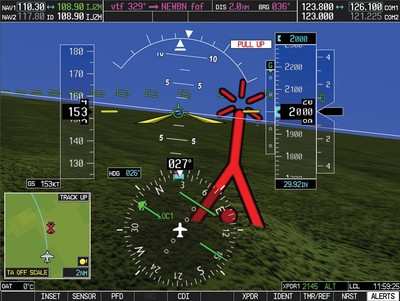
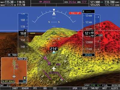
models. Garmin's SVT presents a 3D depiction of terrain, obstacles
and traffic on the G1000's primary flight-display (PFD) so that the
avionics panel replicates what pilots would see outside the cockpit
on a clear day.
"Garmin's SVT brings an unprecedented level of integration and
awareness to pilots of G1000-equipped aircraft," said Gary Kelley,
Garmin's vice president of marketing. "SVT transforms the cockpit
by accurately displaying synthetic terrain, flight hazards, flight
path marker and highway-in-the-sky on the PFD so that the pilot
maintains excellent airborne situational awareness even when flying
in conditions of reduced visibility or darkness. This results in
reduced pilot workload and safer flying."
Garmin's SVT blends information about the aircraft's position
with topographic databases to create and display real-time 3D
images. The information is presented on the G1000's large flight
displays with XGA (1,024x768-pixel) resolution, superior sunlight
readability and wide viewing angles. SVT presents the necessary
information in ways that are easy to understand so pilots feel at
ease interpreting the information.
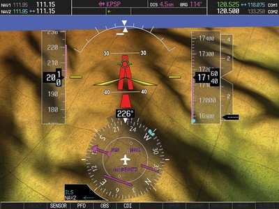
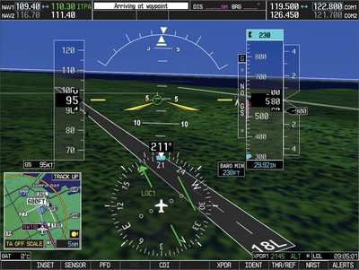
The foundation of SVT is the depiction of 3D terrain, which is
displayed on the PFD(s). Land, water and sky are clearly
differentiated with shading and textures that are similar to the
topographical colors found on the multi-function display (MFD)
moving map. SVT works seamlessly to alert pilots of potential
ground hazards by displaying terrain and obstacles which pose a
threat to the aircraft with appropriate TAWS alert coloring.
Those flying with a TAWS-B enabled (optional) G1000 avionics
suite also have the benefit of receiving voice alerts. Terrain
warnings are also depicted on the MFD with a traditional,
color-coded "X" symbol. If the aircraft does not have TAWS-B
enabled, reduced capability AC 23-26 compliant terrain alerting is
included with SVT.
 Numerous other SVT features increase
safety of flight and help pilots fly with greater precision:
Numerous other SVT features increase
safety of flight and help pilots fly with greater precision:
- Obstacles: Intuitively enlarges obstacle(s) as aircraft
approaches; TAWS based colors are used when the required obstacle
clearance is not met or in the case of potential obstacle
impact
- Traffic: TCAS traffic symbology represented in 3D that changes
size relative to range
- Flight Path Marker: Displays projected path of the
aircraft
- Zero Pitch Line: Clearly distinguishes aircraft's altitude in
relation to nearby terrain
- Gridlines: Drawn on the terrain surface and enhances distance
perception
- Runways: Runway designations and thresholds are superimposed on
terrain data; Unique runway highlighting and enhancements improves
runway visibility from a distance
- Airport Signs: Depicts identifier of nearby airports

Pilots will also appreciate SVT's pathways, or
Highway-In-The-Sky (HITS) guidance. Depicted as 3D "flying
rectangles", pathway guidance symbols help pilots stay on course
when flying en route legs, VNAV legs, GPS/WAAS vertical approach
procedures, ILS approach procedures, and arrival and departure
procedures. When on an ILS approach, pilots will take
advantage of Garmin's patent-pending system whereby SVT relies on
ILS signals to position the pathway. Therefore, when pilots fly
through the SVT boxes on an ILS approach, they will automatically
fly the precision glideslope. Pathways may be enabled or disabled
via a PFD softkey.
"Garmin's SVT is another example of our commitment to
innovation," said Kelley. "Because the G1000 is a truly integrated
and expandable system, all major components are designed and
manufactured by a single company so that they work together to give
pilots the complete picture. SVT is a retrofitable system and
we are working with OEMs to develop a process whereby customers
will have the option of adding SVT to their aircraft with very
little downtime."
SVT also brings MFD enhancements. At the nose of the MFD's
aircraft graphic, pilots will see the field of view scan
(45-degrees lateral scan) and flight path predictor that displays
the aircraft's anticipated flight path.
SVT is expected to be available on G900X-equipped aircraft by
July 2008, and on the G1000 King Air C90 retrofit in 2009.
Integration of SVT into existing G1000 systems or
yet-to-be-delivered G1000 equipped aircraft is being coordinated
with each aircraft manufacturer.
 ANN's Daily Aero-Linx (04.15.24)

