'SIERRA' UAV Photographs Old Ice Floes
A small NASA aircraft completed its first successful science
flight Thursday as part of an expedition to study the receding
Arctic sea ice and improve understanding of its life cycle and the
long-term stability of the Arctic ice cover. The mission continues
through July 24.
NASA's Characterization of Arctic Sea Ice Experiment, known as
CASIE, began a series of unmanned aircraft system flights in
coordination with satellites. Working with the University of
Colorado and its research partners, NASA is using the
remotely-piloted aircraft to image thick, old slabs of ice as they
drift from the Arctic Ocean south through Fram Strait -- which lies
between Greenland and Svalbard, Norway -- into the North Atlantic
Ocean.
NASA's Science Instrumentation Evaluation Remote Research
Aircraft, or SIERRA, will weave a pattern over open ocean and sea
ice to map and measure ice conditions below cloud cover to as low
as 300 feet.
"Our project is attempting to answer some of the most basic
questions regarding the most fundamental changes in sea ice cover
in recent years," said James Maslanik, a research professor at the
University of Colorado at Boulder, and principal investigator for
the NASA mission. "Our analysis of satellite data shows that in
2009 the amount of older ice is just 12 percent of what it was in
1988 -- a decline of 74 percent. The oldest ice types now cover
only 2 percent of the Arctic Ocean as compared to 20 percent during
the 1980s."
SIERRA, laden with scientific instruments, travels long
distances at low altitudes, flying below the clouds. The aircraft
has high maneuverability and slow flight speed. SIERRA's relatively
large payload, approximately 100 pounds, combined with a
significant range of 500 miles and small size of 20 ft. wingspan
makes it the ideal aircraft for this expedition.
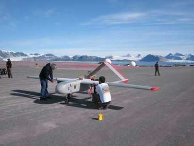
SIERRA Aircraft Photo Credit
NASA
The mission is conducted from the Ny-Alesund research base on
the island of Svalbard, Norway, located near the northeastern tip
of Greenland. Mission planners are using satellite data to direct
flights of the aircraft.
"Today, we demonstrated the utility of small- to medium-class
unmanned aircraft systems for gathering science data in remote
harsh environments during the CASIE mission," said Matt Fladeland,
CASIE project and SIERRA manager at NASA's Ames Research Center in
Moffett Field, Calif.
The aircraft observations will be complemented by NASA satellite
large-scale views of many different features of the Arctic ice. The
Moderate Resolution Imaging Spectroradiometer aboard NASA's Aqua
satellite will be used to identify the ice edge location, ice
features of interest, and cloud cover. Other sensors, such as the
Advanced Microwave Scanning Radiometer -- Earth Observing System on
Aqua and the Quick Scatterometer can penetrate cloud cover and
analyze the physical properties of ice. By using multiple types of
satellite data, in conjunction with the high resolution aircraft
products, more can be learned about ice conditions than is possible
by using one or two data analysis methods.
NASA's CASIE mission supports a larger NASA-funded research
effort titled "Sea Ice Roughness as an Indicator of Fundamental
Changes in the Arctic Ice Cover: Observations, Monitoring, and
Relationships to Environmental Factors." The project also supports
the goals of the International Polar Year, a major international
scientific research effort involving many NASA research efforts to
study large-scale environmental change in Earth's polar
regions.
FMI: http://blogs.nasa.gov/cm/blog/CASIE
 ANN's Daily Aero-Linx (04.13.24)

