Fri, Jun 27, 2003
Breaks Up Over The Pacific At 8000 Feet
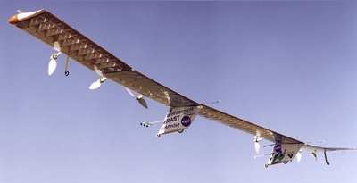
 An extraordinary NASA research
project has had a serious accident. The remotely operated Helios
Prototype aircraft, a proof-of-concept solar-electric flying wing
designed to operate at extremely high altitudes for long duration,
was destroyed when it crashed Thursday during a checkout flight
from the Navy’s Pacific Missile Range Facility (PMRF) on the
Hawaiian island of Kauai.
An extraordinary NASA research
project has had a serious accident. The remotely operated Helios
Prototype aircraft, a proof-of-concept solar-electric flying wing
designed to operate at extremely high altitudes for long duration,
was destroyed when it crashed Thursday during a checkout flight
from the Navy’s Pacific Missile Range Facility (PMRF) on the
Hawaiian island of Kauai.
There was no property damage or injuries on the ground resulting
from the accident. The remotely piloted aircraft came down within
the confines of the PMRF test range over the Pacific Ocean west of
the facility. The cause of the mishap is not yet known.
The solar-electric, propeller-driven aircraft had been flying
under the guidance of ground-based mission controllers for
AeroVironment, Inc., of Monrovia, Calif., the plane’s builder
and operator. The lightweight flying wing had taken off from PMRF
at about 10:06 a.m. on a functional checkout flight and had been
aloft for about 29 minutes over the PMRF test range when the mishap
occurred. The mishap occurred during a shakedown mission in
preparation for a long-endurance mission of almost two days that
had been planned for next month.
The Helios Prototype is one of several remotely piloted aircraft
whose technological development has been sponsored and funded by
NASA under the Environmental Research Aircraft and Sensor
Technology (ERAST) program, managed by NASA’s Dryden Flight
Research Center, Edwards, Calif. Current to power its electric
motors and other systems was generated by high-efficiency solar
cells spread across the upper surface of its 247-foot long wing
during the day and by an experimental fuel cell-based electrical
system at night. The Helios Prototype was designed to fly at
altitudes of up to 100,000 feet on single-day atmospheric science
and imaging missions, as well as perform multi-day
telecommunications relay missions at altitudes of 50,000 to 65,000
feet.
The Helios Prototype set a world altitude record for winged
aircraft of 96,863 feet during a flight from the Navy facility at
Barking Sands, Kauai, in August 2001.
An accident investigation team will be formed by NASA and
supported by AeroVironment and the U.S. Navy to determine the exact
cause of the Helios Prototype mishap.
More News
Aero Linx: International Flying Farmers IFF is a not-for-profit organization started in 1944 by farmers who were also private pilots. We have members all across the United States a>[...]
From 2017 (YouTube Version): Remembrances Of An Israeli Air Force Test Pilot Early in 2016, ANN contributor Maxine Scheer traveled to Israel, where she had the opportunity to sit d>[...]
"We renegotiated what our debt restructuring is on a lot of our debts, mostly with the family. Those debts are going to be converted into equity..." Source: Excerpts from a short v>[...]
Also: B-29 Superfortress Reunion, FAA Wants Controllers, Spirit Airlines Pulls Back, Gogo Galileo Van's Aircraft posted a short video recapping the goings-on around their reorganiz>[...]
Chart Supplement US A flight information publication designed for use with appropriate IFR or VFR charts which contains data on all airports, seaplane bases, and heliports open to >[...]
 ANN's Daily Aero-Linx (04.15.24)

