Navy UAV Down In MD | Aero-News Network
Aero-News Network
RSS icon RSS feed
podcast icon MP3 podcast
Subscribe Aero-News e-mail Newsletter Subscribe

Airborne Unlimited -- Most Recent Daily Episodes

Episode Date

Airborne-Monday

Airborne-Tuesday

Airborne-Wednesday Airborne-Thursday

Airborne-Friday

Airborne On YouTube

Airborne-Unlimited-04.01.24

Airborne-Unlimited-04.16.24

Airborne-FlightTraining-04.17.24 Airborne-Unlimited-04.11.24

Airborne-Unlimited-04.12.24

Join Us At 0900ET, Friday, 4/10, for the LIVE Morning Brief.
Watch It LIVE at
www.airborne-live.net

Tue, Jun 12, 2012

Navy UAV Down In MD

Officials Say Aircraft Was Conducting A Routine Maintenance Flight

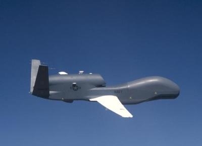
A Navy UAV has gone down on the Eastern Shore of Maryland, according to the Navy and the Coast Guard.

Initial reports are that the 44-foot UAV is part of the Navy's Patuxent River Naval Station's Unmanned Aviation and Strike Weapons program. The Associated Press reports that it went down just after noon Monday near Bloodsworth Island. No injuries were reported in connection with the accident.

The blog SeaWaves indicates that the UAV is one of five Global Hawk aircraft that was acquired from the Air Force for the Broad Area Maritime Surveillance Demonstrator program. The BAMS-D program has been working on employing high-altitude unmanned patrol aircraft since November, 2006.

According to the NAVAIR website, The Navy’s RQ-4A Global Hawk UAVs fly up to 60,000 feet. The high-flying aerial vehicle can operate for more than 30 hours above most weather. Imagery and other data obtained by the aircraft feeds by satellite into the Navy ground segment consisting of a mission control element, a launch and recovery element, and a Navy-designed Tactical Auxiliary Ground Station (TAGS). Flown by Navy and Navy contractor pilots, the asset is controlled from Naval Air Station (NAS) Patuxent River, MD.

BAMS-D was used to develop methods for integrating the Automatic Identification System (AIS) into Fleet operations. Experimentation using BAMS-D also benefited the Naval Sea Systems Command Ocean Surveillance Initiative and Oceanographer of the Navy office activities assessing usefulness of long-endurance, high-altitude unmanned systems in collecting Fleet-relevant meteorological data.

The Coast Guard has set up a safety zone around the marshy area where the aircraft went down in Dorchester County, MD, according to USCG Petty Officer Jonathan Lindberg. (File photo of Navy Global Hawk)

FMI: www.navy.mil, www.uscg.mil

Advertisement

More News

ANN's Daily Aero-Linx (04.15.24)

Aero Linx: International Flying Farmers IFF is a not-for-profit organization started in 1944 by farmers who were also private pilots. We have members all across the United States a>[...]

Classic Aero-TV: 'No Other Options' -- The Israeli Air Force's Danny Shapira

From 2017 (YouTube Version): Remembrances Of An Israeli Air Force Test Pilot Early in 2016, ANN contributor Maxine Scheer traveled to Israel, where she had the opportunity to sit d>[...]

Aero-News: Quote of the Day (04.15.24)

"We renegotiated what our debt restructuring is on a lot of our debts, mostly with the family. Those debts are going to be converted into equity..." Source: Excerpts from a short v>[...]

Airborne 04.16.24: RV Update, Affordable Flying Expo, Diamond Lil

Also: B-29 Superfortress Reunion, FAA Wants Controllers, Spirit Airlines Pulls Back, Gogo Galileo Van's Aircraft posted a short video recapping the goings-on around their reorganiz>[...]

ANN's Daily Aero-Term (04.16.24): Chart Supplement US

Chart Supplement US A flight information publication designed for use with appropriate IFR or VFR charts which contains data on all airports, seaplane bases, and heliports open to >[...]

blog comments powered by Disqus


Advertisement

Advertisement

Podcasts

Advertisement

© 2007 - 2024 Web Development & Design by Pauli Systems, LC