Airport Runway Incursion Prevention Offered By Approach Systems | Aero-News Network
Aero-News Network
RSS icon RSS feed
podcast icon MP3 podcast
Subscribe Aero-News e-mail Newsletter Subscribe

Airborne Unlimited -- Most Recent Daily Episodes

Episode Date

Airborne-Monday

Airborne-Tuesday

Airborne-Wednesday Airborne-Thursday

Airborne-Friday

Airborne On YouTube

Airborne-Unlimited-04.01.24

Airborne-Unlimited-04.16.24

Airborne-FlightTraining-04.17.24 Airborne-Unlimited-04.11.24

Airborne-Unlimited-04.12.24

Join Us At 0900ET, Friday, 4/10, for the LIVE Morning Brief.
Watch It LIVE at
www.airborne-live.net

Fri, May 08, 2009

Airport Runway Incursion Prevention Offered By Approach Systems

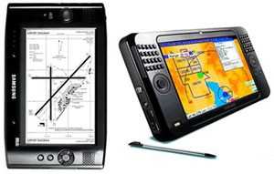
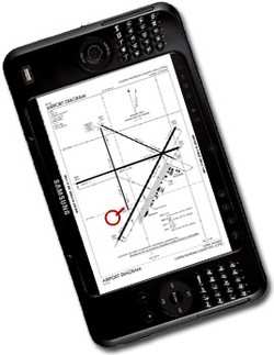
Approach Systems Corporation is disclosing details of 'Approach EasyTaxi,' a free download of geo synchronized location of aircraft on all NACO Airport Diagrams.

Approach is making this application free (for a limited time) in the spirit assisting the FAAs current effort to prevent runway incursions. With Approach EasyTaxi, the company hopes that will be absolutely no reason to line up on the wrong runway or inadvertently cross a runway while taxiing.

Approach EasyTaxi is free and runs on any Windows based platform. Additionally, beginning with the May 2009 release, EasyTaxi free moving map software we will include airport diagrams for all airports that have a NACO airport diagrams (692 airports). Approach EasyTaxi allows the real time display of aircraft position on each NACO airport diagram. Approach EASYTAXI works with all Microsoft based platforms.

Approach EasyTaxi uses detailed NACO database to dynamically render maps of all US airport diagrams and through the use of GPS technology show pilots their position on the airport surface. Now, when landing at an unfamiliar airport and being given confusing ground instructions you no longer have to ask for a "progressive." You'll know exactly where you are on the airport surface, greatly reducing the possibility of crossing a runway.

Approach EasyTaxi is plug & play; the user does not need to "calibrate" any diagram. Calibration for all airport diagrams has already been performed by Approach. Approach EASYTAXI can interface to all standard GPS devices and virtual GPS connections. The cost of Approach EASYTAXI is free, zero, nada, zilch! Approach provides a new updates for changes every 28 days.

Approach APIC provided modern glass cockpit technology on low cost Commercial-off-the-shelf (COTS) platforms based on Microsoft XP, VISTA and Windows Mobile based technologies.

FMI: www.approach-systems.com

Advertisement

More News

ANN's Daily Aero-Linx (04.15.24)

Aero Linx: International Flying Farmers IFF is a not-for-profit organization started in 1944 by farmers who were also private pilots. We have members all across the United States a>[...]

Classic Aero-TV: 'No Other Options' -- The Israeli Air Force's Danny Shapira

From 2017 (YouTube Version): Remembrances Of An Israeli Air Force Test Pilot Early in 2016, ANN contributor Maxine Scheer traveled to Israel, where she had the opportunity to sit d>[...]

Aero-News: Quote of the Day (04.15.24)

"We renegotiated what our debt restructuring is on a lot of our debts, mostly with the family. Those debts are going to be converted into equity..." Source: Excerpts from a short v>[...]

Airborne 04.16.24: RV Update, Affordable Flying Expo, Diamond Lil

Also: B-29 Superfortress Reunion, FAA Wants Controllers, Spirit Airlines Pulls Back, Gogo Galileo Van's Aircraft posted a short video recapping the goings-on around their reorganiz>[...]

ANN's Daily Aero-Term (04.16.24): Chart Supplement US

Chart Supplement US A flight information publication designed for use with appropriate IFR or VFR charts which contains data on all airports, seaplane bases, and heliports open to >[...]

blog comments powered by Disqus


Advertisement

Advertisement

Podcasts

Advertisement

© 2007 - 2024 Web Development & Design by Pauli Systems, LC