Rockwell Collins Launches WAAS-Capable GPS-4000S | Aero-News Network
Aero-News Network
RSS icon RSS feed
podcast icon MP3 podcast
Subscribe Aero-News e-mail Newsletter Subscribe

Airborne Unlimited -- Most Recent Daily Episodes

Episode Date

Airborne-Monday

Airborne-Tuesday

Airborne-Wednesday Airborne-Thursday

Airborne-Friday

Airborne On YouTube

Airborne-Unlimited-04.01.24

Airborne-Unlimited-04.16.24

Airborne-FlightTraining-04.17.24 Airborne-Unlimited-04.11.24

Airborne-Unlimited-04.12.24

Join Us At 0900ET, Friday, 4/10, for the LIVE Morning Brief.
Watch It LIVE at
www.airborne-live.net

Wed, Sep 20, 2006

Rockwell Collins Launches WAAS-Capable GPS-4000S

Will Allow Pilots To Use GPS For Primary Nav

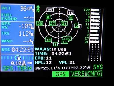
Rockwell Collins told ANN this week the company has launched its Wide Area Augmentation System (WAAS) capable GPS-4000S. The new capability will be available in early 2007 -- and will give pilots the ability to use GPS as a primary means of navigation.

The GPS-4000S sensor and associated WAAS antenna will allow operators to utilize the GPS system, without reliance on other navigation equipment for en route operations and approach procedures authorized for WAAS, such as RNAV (GPS) charts. A WAAS receiver also streamlines preflight preparation by removing the requirement to run a computer-based prediction of Receiver Autonomous Integrity Monitoring (RAIM) availability along the intended routes for US area navigation (RNAV) routes, Standard Instrument Departures (SIDs), and Standard Terminal Arrivals (STARs).

"Just like the GPS-4000A, the GPS-4000S is fully integrated with the Flight Management Systems (FMS) in Rockwell Collins Pro Line 4 and Pro Line 21 systems to provide simple and intuitive operation,"  said Denny Helgeson, vice president and general manager of Business and Regional Systems for Rockwell Collins.

Operators with Rockwell Collins' Flight Management Systems (FMS) who install a GPS-4000S will also be positioned to take advantage of localizer performance vertical guidance (LPV ) approach capability, upon availability of an FMS upgrade option which is scheduled for initial certification in late 2007.

The first customer for this capability is the Federal Aviation Administration (FAA), which signed a contract with Rockwell Collins last November to add Wide Area Augmentation System functionality with localizer performance with vertical guidance (WAAS LPV) to the FAA's flight inspection aircraft.

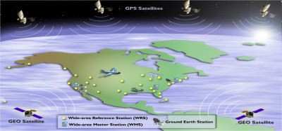
WAAS improves the availability and integrity of GPS navigation by providing horizontal and vertical navigation for precision approach operations for all users at all locations. Additionally, WAAS provides service for all classes of aircraft in all flight operations, including en route navigation, airport departures, and airport arrivals. This includes precision landing approaches with minimums as low as 200 feet at locations throughout the National Airspace System.

FMI: www.rockwellcollins.com

Advertisement

More News

ANN's Daily Aero-Linx (04.15.24)

Aero Linx: International Flying Farmers IFF is a not-for-profit organization started in 1944 by farmers who were also private pilots. We have members all across the United States a>[...]

Classic Aero-TV: 'No Other Options' -- The Israeli Air Force's Danny Shapira

From 2017 (YouTube Version): Remembrances Of An Israeli Air Force Test Pilot Early in 2016, ANN contributor Maxine Scheer traveled to Israel, where she had the opportunity to sit d>[...]

Aero-News: Quote of the Day (04.15.24)

"We renegotiated what our debt restructuring is on a lot of our debts, mostly with the family. Those debts are going to be converted into equity..." Source: Excerpts from a short v>[...]

Airborne 04.16.24: RV Update, Affordable Flying Expo, Diamond Lil

Also: B-29 Superfortress Reunion, FAA Wants Controllers, Spirit Airlines Pulls Back, Gogo Galileo Van's Aircraft posted a short video recapping the goings-on around their reorganiz>[...]

ANN's Daily Aero-Term (04.16.24): Chart Supplement US

Chart Supplement US A flight information publication designed for use with appropriate IFR or VFR charts which contains data on all airports, seaplane bases, and heliports open to >[...]

blog comments powered by Disqus


Advertisement

Advertisement

Podcasts

Advertisement

© 2007 - 2024 Web Development & Design by Pauli Systems, LC