Fri, Apr 04, 2003
 UPS
Aviation Technologies announced the release of its latest software
enhancements for the popular MX20 multi-function display. Version
5.0 software includes several new features designed to enhance
situational awareness in the cockpit.
UPS
Aviation Technologies announced the release of its latest software
enhancements for the popular MX20 multi-function display. Version
5.0 software includes several new features designed to enhance
situational awareness in the cockpit.
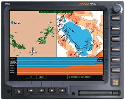
The MX20 will display InFlight graphical weather information
from Weather Services International (WSI). WSI is a leading
supplier of digital weather services for aviation use and has
co-developed the InFlight products with NASA. The MX20 will display
two kilometer resolution NEXRAD weather radar with color-coded
precipitation and other important weather data for the continental
U.S. These high-resolution satellite broadcasts, are updated every
five minutes and can be received on the ground prior to departure.
The ability to receive weather data on the ground or in the sky is
a distinct advantage over ground-based weather providers. The MX20
also displays textual and graphical METARs, TAFs, Echo Tops,
AIRMETs, SIGMETs, and graphical TFRs.
“We are very pleased to offer the full compliment of
weather products from WSI,” says Sam Seery, Director of Sales
and Marketing for UPS Aviation Technologies. “It’s a
nice addition for our MX20 customers looking to add graphical and
textual weather.”
Customers must purchase a satellite receiver from an authorized
WSI dealer and subscribe to a monthly revision service. For
additional information on weather products, prices, and monthly
rates you can call WSI at 1-800-872-2359. A split screen feature
for the MX20 also has been added to allow side-by-side viewing of
any two MX20 charting functions. A vertical profile image can be
viewed on the MX20 allowing pilots to see terrain peaks and
obstructions ahead based on their current flight path and flight
level. Conflicts are easily seen and avoided; complementing the
terrain advisory features of the MX20.
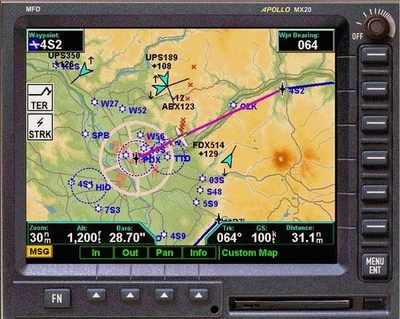
Version 5.0 streamlines operation when the MX20 is used in
conjunction with the new CNX80 GPS/WAAS Integrated Avionics System.
Changing ranges on the CNX80 can automatically control ranges on
the MX20. Even more impressive is when selecting an approach on the
CNX80; the approach plate is automatically loaded and displayed on
MX20’s with the Chart View option. “This combination
greatly reduces pilot workload and is simply unbeatable for
situational awareness during approaches,” says Sam Seery.
Two radar models have been added to the list of compatible
weather radar units for the MX20 I/O models. These include the
Bendix/King RDR 2100 and the RDS81 units. The MX20 I/O can also be
used in conjunction with Honeywell TAWS sensors including the EGPWS
Mark VII and KGP-560 TAWS model. The MX20 with version 5.0 will
start shipping from the factory this May.
Current MX20 customers can receive the 5.0 software free with a
paid update of the navigation data in their units. The MX20 and
MX20 I/O software and navigation data can be replaced via the front
panel data card. Cost of a one–time navigation data update is
$150.00. Chart View customers and pilots who want to receive the
updates or wish to inquire further should call UPS Aviation
Technologies Technical Support at: (800) 525-6726 ext. 3991 (U.S),
or 800.654.3415 ext.3991 (Canada).
More News
Light Gun A handheld directional light signaling device which emits a brilliant narrow beam of white, green, or red light as selected by the tower controller. The color and type of>[...]
"The journey to this achievement started nearly a decade ago when a freshly commissioned Gentry, driven by a fascination with new technologies and a desire to contribute significan>[...]
Aero Linx: JAARS, Inc. For decades now, we’ve landed planes on narrow rivers and towering mountains. We’ve outfitted boats and vehicles to reach villages that rarely se>[...]
"Our driven and innovative team of military and civilian Airmen delivers combat power daily, ensuring our nation is ready today and tomorrow." Source: General Duke Richardson, AFMC>[...]
Aircraft Conflict Predicted conflict, within EDST of two aircraft, or between aircraft and airspace. A Red alert is used for conflicts when the predicted minimum separation is 5 na>[...]
 ANN's Daily Aero-Term (04.20.24): Light Gun

