Airguide Publications Announces Release of iEFB for Apple
iPad
By Deborah Grigsby
The little brown book has gone digital. California-based
Airguide Publications recently announced the availability of
"Flight Guide iEFB," a new Apple iPad application that stores and
displays pertinent airport, chart and supplementary data either
during flight or general aviation planning purposes.
Flight Guide iEPD Application For The Apple
iPad
The Flight Guide iEFB makes use of Apple's "pan, pitch, and
drag" interface enabling pilots to zoom in and out of all airport
chart and information pages with just a tough of the finger.
There's even a special screen lock to ensure data is not closed or
rotated by inadvertent or unintentional contact. "We have data
plans available for both VFR and IFR pilots that include high
quality airport and supplementary information, sectionals, terminal
area charts, approach plates, high and low enroute charts for the
lower 48 states, Alaska, Hawaii, and the Caribbean," said Brenda
Garcia, Air Guide Publications publisher.
According to Garcia, what distinguishes Flight Guide iEFB is
that they research their own airport information and "finely
detail" nearly 5,000 airports with taxiways identified and business
on field locations pointed out, as well as current and nearby fuel
prices. Designed with pilots in mind, the Flight Guide iEFB airport
pages provide critical information at a glance through limited menu
selection. "The information we're showing in the 'content list'
window is a key feature," said Larry Garcia, Airguide Publications
owner. "I've seen other apps out there where it takes so many
windows to find what you're looking for. We have it all right there
at a glance."

Larry and Brenda Garcia
Garcia also said the iEFB will soon be integrating moving
seamless maps, and geo-referenced charts as well as a proprietary
GPS device. "We've had to disable our geo-referenced charts
currently because the GPS in the iPad is not aviation grade,"
explained Garcia. "So don't let anyone fool you--it is unsafe. The
GPS device we are developing is Apple-approved. I don't think
anybody else has an Apple-approved device like that. I pretty much
think were the only one." Garcia went on to add that the
iPad-based GPS is celluar based and is pretty much "hit and miss,"
and the company will soon introduce a proprietary GPS device of
their own. "So we are coming out with our own GPS-to-iPad device
under the Flight Guide name and that will give you a perfect GPS
signal and location on our charts, and will work only on our
app."
The device will most likely will be tethered on the bottom of
the iPad as Garcia pointed out Apple will not permit them to use
Bluetooth technology at this time. "But the nice thing about
the iPad is that you can spin (the screen view) it around so the
connector is on top and you'll get better GPS signal (with the
device) on top."

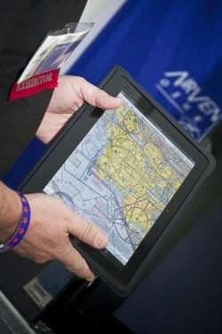
Larry Garcia Demonstrates The iEFB
Larger in size, the iPad is a suitable platform for iEFB as it
is similar in size to standard approach plates, and information can
easily be zoomed in or out for ease of reading. Finally, The
Flight Guide iEFB incorporates geo-referenced hyperlinked charts
that enable the pilot to instantly bring up information on any
airport simply by touching that airport's icon on the chart.
Sectionals will be hyperlinked as well. Flight Guide iEFB is
available for free through the Apple App Store. Data plan pricing
ranges from $9.95 to $19.95 per month. GPS moving map,
seamless charts and geo-reference approach plates, are all part of
a continuing effort to make their products better concluded
Garcia. There is no regional limitation for Flight Guide iEFB
and products are expected to be available this fall.
 ANN's Daily Aero-Linx (04.17.24)

