Tue, Apr 29, 2008
Upgrade May Now Be Deployed Throughout EU
Chelton Flight Systems, part of Cobham’s Avionics and
Surveillance Division, is pleased to announce that the European
Aviation Safety Agency (EASA) has approved software version 6.0B
for use on the company’s Electronic Flight Information System
(EFIS). European Technical Standard Order (ETSO) 210.1028 allows
6.0B deployment on hundreds of fixed- and rotary-wing aircraft
within countries under EASA’s jurisdiction.
The company states software version 6.0B features a DO-178B
Level-A certification (FAA) and over 40 significant benefits for
end-users, including:
- ADS-B datalink display functions, including TIS-B (traffic) and
FIS-B (flight information, including
weather)
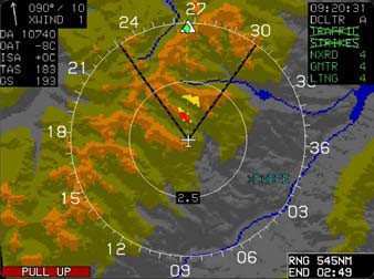
- WSI Weather. Supported products include NEXRAD Weather Radar,
Echo Tops, Graphical METARs, Textual METARs, Textual TAFs,
Lightning, SIGMETs/AIRMETs, TFRs, and Winds/Temps aloft
- Holding Patterns may be created at any fix or waypoint; entries
are calculated automatically
- Nearest ILS Approaches. One touch activates an ILS approach,
sets the inbound OBS course, and sends the ILS frequency to a
remotely-tuned NAV radio
- Enhanced FMS Capability including vertical navigation (VNAV)
and waypoint offsets
- Vertical Deviation Indicator for RNAV Approaches and enroute
VNAV capability
- Expanded Hover Vector for Helicopters displayed with large
radar altitude scale on MFD
- Autopilot Mode Source Annunciation for use with existing legacy
analog autopilots
- Shaded Relief Terrain Depiction on MFD resembling a satellite
image
- TCAS-II interface and resolution advisory symbology
- Basic ADI Mode for transition and training
- FMS-Style Navigation Log for easy preview of procedures
- Dual-Sensor Support with comparators and cross-side
switching
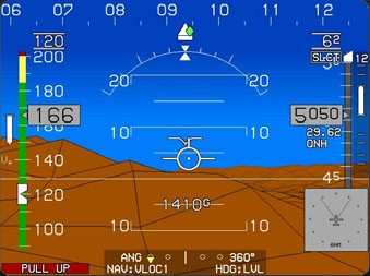
Chelton’s Electronic Flight Information System, or EFIS,
includes one to four display units. The Primary Flight Display
features real-time, forward-looking 3-D perspective terrain
modeling anywhere in the world, with GPS/WAAS positioning, and HITS
(Highway-In-The-Sky) predictive flight director guidance from
takeoff to touchdown. Chelton’s autopilot interface can guide
the aircraft from through DP’s and STAR’s, arc
approaches, procedure turns, and even complex holding pattern
entries with no pilot interaction.
The integral master caution voice warning system provides a wide
range of alarm and alert information that appears on the screen if
any undesirable conditions arise along the flight path.
More News
Aero Linx: Florida Antique Biplane Association "Biplanes.....outrageous fun since 1903." That quote really defines what the Florida Antique Biplane Association (FABA) is all about.>[...]
Beyond Visual Line Of Sight (BVLOS) The operation of a UAS beyond the visual capability of the flight crew members (i.e., remote pilot in command [RPIC], the person manipulating th>[...]
Also: ForeFlight Upgrades, Cicare USA, Vittorazi Engines, EarthX We have a number of late-breaking news highlights from the 2024 Innovation Preview... which was PACKED with real ne>[...]
“For Montaer Aircraft it is a very prudent move to incorporate such reliable institution as Ocala Aviation, with the background of decades in training experience and aviation>[...]
Maximum Authorized Altitude A published altitude representing the maximum usable altitude or flight level for an airspace structure or route segment. It is the highest altitude on >[...]
 ANN's Daily Aero-Linx (04.13.24)

