FAA Maps Out Long-Term Plan For Enhanced Satellite Navigation | Aero-News Network
Aero-News Network
RSS icon RSS feed
podcast icon MP3 podcast
Subscribe Aero-News e-mail Newsletter Subscribe

Airborne Unlimited -- Most Recent Daily Episodes

Episode Date

Airborne-Monday

Airborne-Tuesday

Airborne-Wednesday Airborne-Thursday

Airborne-Friday

Airborne On YouTube

Airborne-Unlimited-04.01.24

Airborne-Unlimited-04.16.24

Airborne-FlightTraining-04.17.24 Airborne-Unlimited-04.11.24

Airborne-Unlimited-04.12.24

Join Us At 0900ET, Friday, 4/10, for the LIVE Morning Brief.
Watch It LIVE at
www.airborne-live.net

Sun, May 09, 2004

FAA Maps Out Long-Term Plan For Enhanced Satellite Navigation

Says It's Committed To WAAS

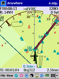
Top officials at the FAA have told AOPA that the agency is committed to maturing satellite-based navigation for the long haul using the wide area augmentation system (WAAS). During a meeting at AOPA headquarters on Tuesday, executives from the FAA's Air Traffic Organization shared the agency's latest program developments. They said part of the plan for supporting general aviation's transition to WAAS is to develop 500 WAAS approaches each year, making the system more attractive to GA pilots.

WAAS is a ground-based system that adjusts for errors in signals from the Global Positioning System, providing unparalleled navigation performance. The FAA has taken a building block approach to WAAS, adding enhancements as they become available. The system currently supports approaches with minimum weather standards close to those for instrument landing systems (ILS). Ultimately it will be capable of precise ILS Category 1 guidance for approaches into airports that don't have instrument landing system equipment.

"Using WAAS to deliver all-weather access to airports increases a local community's access to the world," said AOPA President Phil Boyer. "This is why AOPA embraced this navigation system early on."

The FAA expects to be able to deliver Category I ILS performance throughout the continental United States and parts of Alaska using WAAS. But that won't happen until after a full constellation of new-generation GPS satellites are in place, expected sometime around 2013.

"The fact that the FAA is looking beyond 2013 all the way to at least 2028 illustrates the agency's commitment to a satellite-based navigation system based on WAAS," said AOPA Senior Director of Advanced Technology Randy Kenagy. "And the agency's acknowledgement that they have to turn out hundreds of WAAS approaches each year is the first step in getting the approach production started."

AOPA has championed a conversion to a satellite-based navigation system since 1990. And during the development of what has become WAAS, the association repeatedly told the FAA that the system must be able to deliver the same accuracy, availability, and dependability as the current instrument landing system.

FMI: www.aopa.org

Advertisement

More News

ANN's Daily Aero-Linx (04.15.24)

Aero Linx: International Flying Farmers IFF is a not-for-profit organization started in 1944 by farmers who were also private pilots. We have members all across the United States a>[...]

Classic Aero-TV: 'No Other Options' -- The Israeli Air Force's Danny Shapira

From 2017 (YouTube Version): Remembrances Of An Israeli Air Force Test Pilot Early in 2016, ANN contributor Maxine Scheer traveled to Israel, where she had the opportunity to sit d>[...]

Aero-News: Quote of the Day (04.15.24)

"We renegotiated what our debt restructuring is on a lot of our debts, mostly with the family. Those debts are going to be converted into equity..." Source: Excerpts from a short v>[...]

Airborne 04.16.24: RV Update, Affordable Flying Expo, Diamond Lil

Also: B-29 Superfortress Reunion, FAA Wants Controllers, Spirit Airlines Pulls Back, Gogo Galileo Van's Aircraft posted a short video recapping the goings-on around their reorganiz>[...]

ANN's Daily Aero-Term (04.16.24): Chart Supplement US

Chart Supplement US A flight information publication designed for use with appropriate IFR or VFR charts which contains data on all airports, seaplane bases, and heliports open to >[...]

blog comments powered by Disqus


Advertisement

Advertisement

Podcasts

Advertisement

© 2007 - 2024 Web Development & Design by Pauli Systems, LC