Four Lost In Georgia Bonanza Accident | Aero-News Network
Aero-News Network
RSS icon RSS feed
podcast icon MP3 podcast
Subscribe Aero-News e-mail Newsletter Subscribe

Airborne Unlimited -- Most Recent Daily Episodes

Episode Date

Airborne-Monday

Airborne-Tuesday

Airborne-Wednesday Airborne-Thursday

Airborne-Friday

Airborne On YouTube

Airborne-Unlimited-04.22.24

Airborne-Unlimited-04.16.24

Airborne-FlightTraining-04.17.24 Airborne-AffordableFlyers-04.18.24

Airborne-Unlimited-04.19.24

Join Us At 0900ET, Friday, 4/10, for the LIVE Morning Brief.
Watch It LIVE at
www.airborne-live.net

Sun, Feb 11, 2007

Four Lost In Georgia Bonanza Accident

Plane Disappears From Radar After Cleared To Descend

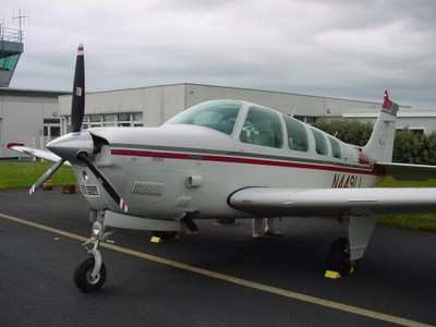
A Beechcraft Bonanza 36 crashed in a training area on Fort Stewart, GA, killing four people Friday night, according to the Associated Press.

The plane (file photo of type, above) was en route to Anderson, SC, from Titusville, FL, when it went down, said FAA spokeswoman Kathleen Bergen. The cause of the crash is under investigation.

NTSB officials say the Bonanza was flying at 13,000 feet when the pilot requested a lower altitude. The pilot was cleared for 11,000 feet and as the plane began its descent, disappeared from radar.

"Air traffic control lost contact with the flight at about 6:15 pm," Bergan said. "The wreckage wasn't found until almost midnight."

It took emergency responders more than five hours to find the wreckage in a heavily wooded area on the vast Army post, said Fort Stewart spokesman Kevin Larson.

Larson added the plane went down in a densely-wooded training area about six miles west of the post's garrison where Fort Stewart's headquarters, barracks and motorpools are located.

Four bodies were found among the wreckage, he said. Their identities were not released.

Bergen said the plane was following a flight plan approved by ATC and did not appear to be violating any airspace restrictions.

Fort Stewart has the largest land area of any Army post east of the Mississippi River, covering about 430 square miles. Most of the area is heavily wooded and used for training.

FMI: www.ntsb.gov, www.stewart.army.mil

Advertisement

More News

ANN's Daily Aero-Term (04.20.24): Light Gun

Light Gun A handheld directional light signaling device which emits a brilliant narrow beam of white, green, or red light as selected by the tower controller. The color and type of>[...]

Aero-News: Quote of the Day (04.20.24)

"The journey to this achievement started nearly a decade ago when a freshly commissioned Gentry, driven by a fascination with new technologies and a desire to contribute significan>[...]

ANN's Daily Aero-Linx (04.21.24)

Aero Linx: JAARS, Inc. For decades now, we’ve landed planes on narrow rivers and towering mountains. We’ve outfitted boats and vehicles to reach villages that rarely se>[...]

Aero-News: Quote of the Day (04.21.24)

"Our driven and innovative team of military and civilian Airmen delivers combat power daily, ensuring our nation is ready today and tomorrow." Source: General Duke Richardson, AFMC>[...]

ANN's Daily Aero-Term (04.21.24): Aircraft Conflict

Aircraft Conflict Predicted conflict, within EDST of two aircraft, or between aircraft and airspace. A Red alert is used for conflicts when the predicted minimum separation is 5 na>[...]

blog comments powered by Disqus


Advertisement

Advertisement

Podcasts

Advertisement

© 2007 - 2024 Web Development & Design by Pauli Systems, LC