North Dakota TFR: 08/06/04 | Aero-News Network
Aero-News Network
RSS icon RSS feed
podcast icon MP3 podcast
Subscribe Aero-News e-mail Newsletter Subscribe

Airborne Unlimited -- Most Recent Daily Episodes

Episode Date

Airborne-Monday

Airborne-Tuesday

Airborne-Wednesday Airborne-Thursday

Airborne-Friday

Airborne On YouTube

Airborne-Unlimited-04.22.24

Airborne-Unlimited-04.16.24

Airborne-FlightTraining-04.17.24 Airborne-AffordableFlyers-04.18.24

Airborne-Unlimited-04.19.24

Join Us At 0900ET, Friday, 4/10, for the LIVE Morning Brief.
Watch It LIVE at
www.airborne-live.net

Fri, Aug 06, 2004

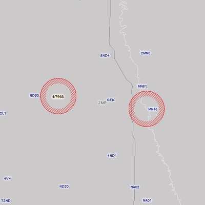
North Dakota TFR: 08/06/04

NOTAM Number: FDC 4/7966
Location: Grand Forks, North Dakota
Beginning Date: August 06, 2004 at 16:00 UTC (August 06, 2004 at 11:00 CDT)
Ending Date: August 06, 2004 at 19:55 UTC (August 06, 2004 at 14:55 CDT)
Reason for NOTAM: Temporary flight restrictions for national security
Type: VIP
Replaced NOTAM(s): n/a
FAA Contact(Pilots):
No Pilots May Operate An Aircraft in the Areas Covered by this Notam Except as Described.


Affected Area(s)
 
Area A
 Airspace Definition:
 Circle Center: 9 nautical miles from GRAND FORKS VOR_DME(GFK) on the 264 radial (Latitude: 47�57'39"N, Longitude: 97�24'3"W)
 Radius: 3 nautical miles
 Altitude: From and including the surface up to 3000 feet
 Operating Restrictions and Requirements:
 Effective Date: August 06, 2004 at 16:00 UTC (August 06, 2004 at 11:00 CDT) - August 06, 2004 at 16:50 UTC (August 06, 2004 at 11:50 CDT)
 
Area B
 Airspace Definition:
 Circle Center: 6 nautical miles from GRAND FORKS VOR_DME(GFK) on the 95 radial (Latitude: 47�55'44"N, Longitude: 97�1'51"W)
 Radius: 3 nautical miles
 Altitude: From and including the surface up to 3000 feet
 Operating Restrictions and Requirements:
 Effective Date: August 06, 2004 at 16:35 UTC (August 06, 2004 at 11:35 CDT) - August 06, 2004 at 18:25 UTC (August 06, 2004 at 13:25 CDT)
 
Area C
 Airspace Definition:
 Circle Center: 8 nautical miles from GRAND FORKS VOR_DME(GFK) on the 264 radial (Latitude: 47�57'39"N, Longitude: 97�24'3"W)
 Radius: 3 nautical miles
 Altitude: From and including the surface up to 3000 feet
 Operating Restrictions and Requirements:
 Effective Date: August 06, 2004 at 18:05 UTC (August 06, 2004 at 13:05 CDT) - August 06, 2004 at 19:55 UTC (August 06, 2004 at 14:55 CDT)
 
Other Information:
ARTCC: ZMP
IssueDate: August 05, 2004 at 13:34 UTC (August 05, 2004 at 8:34 CDT)
Authority: Title 14 CFR section 91.141

FMI: http://tfr.faa.gov/tfr/jsp/list.jsp

Advertisement

More News

ANN's Daily Aero-Term (04.20.24): Light Gun

Light Gun A handheld directional light signaling device which emits a brilliant narrow beam of white, green, or red light as selected by the tower controller. The color and type of>[...]

Aero-News: Quote of the Day (04.20.24)

"The journey to this achievement started nearly a decade ago when a freshly commissioned Gentry, driven by a fascination with new technologies and a desire to contribute significan>[...]

ANN's Daily Aero-Linx (04.21.24)

Aero Linx: JAARS, Inc. For decades now, we’ve landed planes on narrow rivers and towering mountains. We’ve outfitted boats and vehicles to reach villages that rarely se>[...]

Aero-News: Quote of the Day (04.21.24)

"Our driven and innovative team of military and civilian Airmen delivers combat power daily, ensuring our nation is ready today and tomorrow." Source: General Duke Richardson, AFMC>[...]

ANN's Daily Aero-Term (04.21.24): Aircraft Conflict

Aircraft Conflict Predicted conflict, within EDST of two aircraft, or between aircraft and airspace. A Red alert is used for conflicts when the predicted minimum separation is 5 na>[...]

blog comments powered by Disqus


Advertisement

Advertisement

Podcasts

Advertisement

© 2007 - 2024 Web Development & Design by Pauli Systems, LC