Plane Was Being Returned To Wrangell, AK Following Maintenance
The NTSB has released a preliminary report from an accident which occurred July 11 at Ketchikan International Airport, (PKTN) Ketchikan, Alaska that resulted in the fatal injury of the pilot.
According to the report, the Piper PA-24-180 (Comanche) sustained substantial damage after impacting terrain during a visual approach about 4 miles south of PKTN. The airline transport pilot sustained fatal injuries. The airplane was registered to the Law Offices of Michael P Nash PC and operated by the pilot as a personal visual flight rules (VFR) flight. Marginal visual meteorological conditions prevailed at the destination and no flight plan had been filed. The flight departed Friday Harbor Airport (KFHR), Friday Harbor, Washington, about 1010 Alaska daylight time.
A family member of the pilot stated that the purpose of the flight was to return the airplane home to the Wrangell Airport (WRG) (PAWG), Wrangell, Alaska, after the airplane's annual inspection at FHR. The pilot flew this route often and intended to stop at PKTN to purchase their less expensive fuel before continuing onto WRG. On the morning of the flight, the pilot told his family that the forecast weather for PKTN "wasn't looking good," and he intended to fly around Ketchikan and continue onto WRG if the weather in PKTN was not good upon his arrival. He stated that he had 6 hours of fuel onboard and his expected time of arrival was 1445. The flight from KFHR to PKTN is about 522 nautical miles (nm), and WRG is about 70 nm further.

According to an FAA Ketchikan Flight Service Station (KTN FSS) report, about 1411 the pilot called PKTN FSS 10 miles southeast of PKTN with the current Automatic Flight Information Service (AFIS) weather Lima. He stated he intended on entering a right downwind for PKTN runway 11. About 5 minutes later, the flight crew of an inbound Alaska Airlines Boeing 737 contacted PKTN FSS with intentions to enter a left downwind for PKTN runway 11. The accident pilot then reported that he "was hung up" and could not enter a right downwind but would wait for traffic to clear prior to entering a left downwind. There were no further communications received by the pilot. PKTN FSS personnel attempted to contact the accident airplane on the radio and after no response was heard they notified local search and rescue units. The Ketchikan Volunteer Rescue Squad, Ketchikan Police, Ketchikan Alaska State Troopers, US Coast Guard and local operators searched for the missing airplane until about 1630 when the wreckage was
located.
A preliminary review of archived FAA radar and Automatic Dependent Surveillance Broadcast (ADSB) data revealed that the airplane flew primarily a direct route to the KTN terminal area. At 1418, north of Judy Hill, the airplane initiated a left from a 322° track toward the southwest. The airplane descended from 625 ft down to 325 ft during the left turn and the last ground speed data was 118 knots.
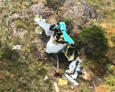
The wreckage was located on the northwest side of Judy Hill at an elevation of 380 ft in lightly forested muskeg covered terrain. Judy Hill is an 814 ft hill situated at the southeast end of Gravina Island in the Tongass National Forrest. All major airplane components were located at the accident site. The debris track was about 300 ft long and 40 ft wide on a heading of 193° true. The debris field consisted of broken treetops, long deep ground scars, wing and empennage sections, and terminated at the inverted main fuselage, engine and inboard wings. Refer to figure 2. The wreckage has been recovered to a secure facility for further examination.
(Images provided with NTSB preliminary report)
 ANN's Daily Aero-Linx (04.15.24)

