Tue, Jul 26, 2005
EFB Component For Voyager Flight Software System
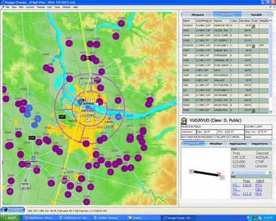
Seattle Avionics Software has launched its GlassView Moving
Map/EFB software.

GlassView is the latest component tool for the new Voyager
Flight Software System, which includes SmartPlan Premier flight
planner, SmartPlan Express flight planner, GlassView moving map,
SmartPlates, instrument procedure management program with Part
91-compliant FAA (NACO) digital approach plates, or XM WX Weather,
live, in-cockpit weather. Regardless of which components are
selected, they all automatically integrate into a seamless single
application custom-tailored to each pilot's needs.
 One of GlassView's most innovative
features is its ability to automatically adapt to pilots' needs as
their situation changes with phases of flight. For example, in
addition to showing basic GPS information, Voyager's GlassView
moving map keeps you safe by automatically displaying nearest
airport, navaid and airspace information as your position changes
and shows detailed airport and procedure information as you
approach your destination. Not just the data, but also which type
of data is displayed, and the program's actual layout all change,
("morph") automatically as a flight progresses.
One of GlassView's most innovative
features is its ability to automatically adapt to pilots' needs as
their situation changes with phases of flight. For example, in
addition to showing basic GPS information, Voyager's GlassView
moving map keeps you safe by automatically displaying nearest
airport, navaid and airspace information as your position changes
and shows detailed airport and procedure information as you
approach your destination. Not just the data, but also which type
of data is displayed, and the program's actual layout all change,
("morph") automatically as a flight progresses.
GlassView always shows flight critical data while the GPS
positioned plane moves across geo-referenced sectional and enroute
charts to give pilots unmatched situational awareness during
enroute and approach operations. When integrated with SmartPlates,
GlassView also provides crisp, digital Part 91 compliant NACO
terminal and approach procedures for all 50 states. When GlassView
is integrated with Voyager's SmartPlan Premier flight planner, the
program "auto-switches" from pre-flight planning mode into
enroute/moving map mode when it senses movement from the GPS card
or device.
When Glassview's easy to use interface and phase-of-flight
intelligence is combined with the power of Voyager Flight Planner's
SmartRouter, you have a truly unique and powerful combination
unparalleled in the aviation industry. When XM WX Weather and
SmartPlates are integrated with GlassView, you have better
functionality than a glass cockpit on your kneeboard for a fraction
of the initial and ongoing cost of panel-mount systems.
Current Voyager Premier customers will receive the GlassView Moving
Map/EFB component free of charge with their current annual NavData
subscription.
More News
Aero Linx: Florida Antique Biplane Association "Biplanes.....outrageous fun since 1903." That quote really defines what the Florida Antique Biplane Association (FABA) is all about.>[...]
Beyond Visual Line Of Sight (BVLOS) The operation of a UAS beyond the visual capability of the flight crew members (i.e., remote pilot in command [RPIC], the person manipulating th>[...]
Also: ForeFlight Upgrades, Cicare USA, Vittorazi Engines, EarthX We have a number of late-breaking news highlights from the 2024 Innovation Preview... which was PACKED with real ne>[...]
“For Montaer Aircraft it is a very prudent move to incorporate such reliable institution as Ocala Aviation, with the background of decades in training experience and aviation>[...]
Maximum Authorized Altitude A published altitude representing the maximum usable altitude or flight level for an airspace structure or route segment. It is the highest altitude on >[...]
 ANN's Daily Aero-Linx (04.13.24)

