Boeing Delta II Delivers GPS Satellite To Orbit | Aero-News Network
Aero-News Network
RSS icon RSS feed
podcast icon MP3 podcast
Subscribe Aero-News e-mail Newsletter Subscribe

Airborne Unlimited -- Most Recent Daily Episodes

Episode Date

Airborne-Monday

Airborne-Tuesday

Airborne-Wednesday Airborne-Thursday

Airborne-Friday

Airborne On YouTube

Airborne-Unlimited-04.01.24

Airborne-Unlimited-04.09.24

Airborne-Unlimited-04.10.24 Airborne-Unlimited-04.11.24

Airborne-Unlimited-04.12.24

Join Us At 0900ET, Friday, 4/10, for the LIVE Morning Brief.
Watch It LIVE at
www.airborne-live.net

Mon, Nov 20, 2006

Boeing Delta II Delivers GPS Satellite To Orbit

Second Launch In Less Than Two Months

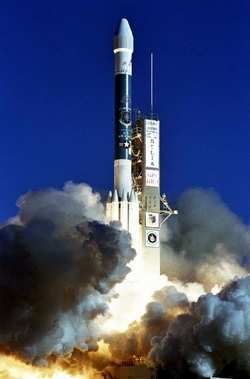
Chalk up another successful launch for Boeing's Delta II launch vehicle -- as one of the boosters successfully delivered to orbit a replenishment Block IIR Global Positioning System (GPS) satellite for the US Air Force Friday.

The Delta II rocket carrying the GPS IIR-16 (M) satellite lifted off from Space Launch Complex 17A at Cape Canaveral Air Force Station, FL at 2:12 pm EST, deploying the satellite to a transfer orbit 68 minutes later.

Delta IIs have launched all GPS IIR satellites. The launch also marked the second GPS mission aboard a Boeing Delta II in less than two months. GPS IIR-15 lifted off from Cape Canaveral on September 25.

"Our Delta team understands the importance GPS satellites play in protecting our military and helping them defend our country," said Dan Collins, vice president and general manager, Boeing Launch Systems. "The Delta II vehicle has a strong record of performance, and I am proud of the team's commitment to mission success and our role in sustaining the GPS constellation."

The Delta II 7925-9.5 configuration vehicle used for the mission featured a Boeing first stage booster powered by a Pratt & Whitney Rocketdyne RS-27A main engine and nine Alliant Techsystems (ATK) solid rocket boosters. An Aerojet AJ10-118K engine powered the storable propellant restartable second stage. A Thiokol Star-48B solid rocket motor propelled the third stage prior to spacecraft deployment. The rocket also flew with a nine-and-a-half-foot diameter payload fairing.

A redundant inertial flight control assembly built by L3 Communications Space & Navigation provided guidance and control for the rocket, enabling a precise deployment of the satellite.

GPS IIR-16 (M) is the third of the modernized GPS satellites that feature greater accuracy, increased resistance to interference and enhanced performance for users.

The GPS network supports US military operations conducted from aircraft, ships, land vehicles and by ground personnel. Additional uses include mapping, aerial refueling and rendezvous, geodetic surveys, and search and rescue operations.

GPS provides military and civilian users 3-D position location data in longitude, latitude and elevation as well as precise time and velocity. The satellites orbit the Earth every 12 hours, emitting continuous navigation signals. The signals are so accurate, time can be figured to within one millionth of a second, velocity within a fraction of a mile-per-second and location to within 100 feet.

FMI: www.boeing.com, www.af.mil

Advertisement

More News

ANN's Daily Aero-Linx (04.13.24)

Aero Linx: Florida Antique Biplane Association "Biplanes.....outrageous fun since 1903." That quote really defines what the Florida Antique Biplane Association (FABA) is all about.>[...]

ANN's Daily Aero-Term (04.13.24): Beyond Visual Line Of Sight (BVLOS)

Beyond Visual Line Of Sight (BVLOS) The operation of a UAS beyond the visual capability of the flight crew members (i.e., remote pilot in command [RPIC], the person manipulating th>[...]

Airborne 04.09.24: SnF24!, Piper-DeltaHawk!, Fisher Update, Junkers

Also: ForeFlight Upgrades, Cicare USA, Vittorazi Engines, EarthX We have a number of late-breaking news highlights from the 2024 Innovation Preview... which was PACKED with real ne>[...]

Aero-News: Quote of the Day (04.14.24)

“For Montaer Aircraft it is a very prudent move to incorporate such reliable institution as Ocala Aviation, with the background of decades in training experience and aviation>[...]

ANN's Daily Aero-Term (04.14.24): Maximum Authorized Altitude

Maximum Authorized Altitude A published altitude representing the maximum usable altitude or flight level for an airspace structure or route segment. It is the highest altitude on >[...]

blog comments powered by Disqus


Advertisement

Advertisement

Podcasts

Advertisement

© 2007 - 2024 Web Development & Design by Pauli Systems, LC