Tue, Jul 19, 2005
I Can See Clearly Now...
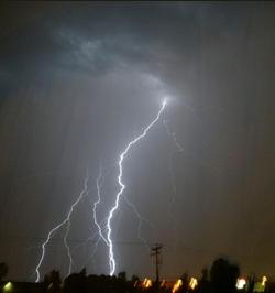
 Jeppesen says it's recently started
adding lightning weather maps to its lineup of weather products.
The lightning data is provided by the US Precision Lightning
Network (USPLN), a partnership between TOA Systems and Weather
Decisions Technologies (WDT). TOA Systems designed, built and
installed the lightning sensors, and WDT distributes the data and
provides applications that display the data.
Jeppesen says it's recently started
adding lightning weather maps to its lineup of weather products.
The lightning data is provided by the US Precision Lightning
Network (USPLN), a partnership between TOA Systems and Weather
Decisions Technologies (WDT). TOA Systems designed, built and
installed the lightning sensors, and WDT distributes the data and
provides applications that display the data.
New technology allows the detection of both cloud-to-ground
lightning as well as lightning within clouds. Cloud-to-cloud
lightning data is highly pertinent to pilots and
dispatchers—typically more than 70 percent of all lightning
strikes happen within clouds. Before Jeppesen began offering these
new weather maps, only cloud-to-ground lightning data was
available. By utilizing the latest technologies, Jeppesen is now
able to provide a more complete lightning picture to its customers.
The new lightning charts rely on 90 sensors across the United
States that regularly detect lightning strikes as far away as
northern Canada, the Caribbean, Mexico, Latin America, northern
South America and the eastern Pacific out to Hawaii.
 Jeppesen will offer USPLN lightning
data as separate maps that are updated every 10-15 minutes as well
as lightning data with infrared and visible satellite images. In
areas outside of the NEXRAD radar network, lightning data is the
best way to determine if convective activity and thunderstorms are
present. The display software allows Jeppesen to show past
lightning strikes as well as current strikes, so users can see
trends in the activity. This is helpful in determining if a
thunderstorm is growing or decaying and showing the movement of the
active cells.
Jeppesen will offer USPLN lightning
data as separate maps that are updated every 10-15 minutes as well
as lightning data with infrared and visible satellite images. In
areas outside of the NEXRAD radar network, lightning data is the
best way to determine if convective activity and thunderstorms are
present. The display software allows Jeppesen to show past
lightning strikes as well as current strikes, so users can see
trends in the activity. This is helpful in determining if a
thunderstorm is growing or decaying and showing the movement of the
active cells.
"The addition of the USPLN lightning data to Jeppesen's weather
products is another step in providing the best aviation weather
information to our customers," said Mike Cetinich, product manager.
"With the recent additions of a NEXRAD forecast product, worldwide
turbulence and icing maps, and now the USPLN lightning data,
Jeppesen is at the forefront of state-of-the-art aviation weather
products. We are committed and solely focused on aviation weather
products that add value for the customer, and help them make more
informed decisions."
More News
Light Gun A handheld directional light signaling device which emits a brilliant narrow beam of white, green, or red light as selected by the tower controller. The color and type of>[...]
"The journey to this achievement started nearly a decade ago when a freshly commissioned Gentry, driven by a fascination with new technologies and a desire to contribute significan>[...]
Aero Linx: JAARS, Inc. For decades now, we’ve landed planes on narrow rivers and towering mountains. We’ve outfitted boats and vehicles to reach villages that rarely se>[...]
"Our driven and innovative team of military and civilian Airmen delivers combat power daily, ensuring our nation is ready today and tomorrow." Source: General Duke Richardson, AFMC>[...]
Aircraft Conflict Predicted conflict, within EDST of two aircraft, or between aircraft and airspace. A Red alert is used for conflicts when the predicted minimum separation is 5 na>[...]
 ANN's Daily Aero-Term (04.20.24): Light Gun

