Probable Cause Report Indicates That The Airplane Was
Overloaded, Out Of CG Envelope
 The NTSB has released a probable cause report in a fatal
accident which occurred on departure from Gaston's White River
Resort near Lakeview, AR in June of 2009. The pilot, who suffered
fatal injuries in the accident, told one of the passengers who
survived that they would need "all the runway" go get off the
ground. Two passengers also suffered fatal injuries when the
airplane went down.
The NTSB has released a probable cause report in a fatal
accident which occurred on departure from Gaston's White River
Resort near Lakeview, AR in June of 2009. The pilot, who suffered
fatal injuries in the accident, told one of the passengers who
survived that they would need "all the runway" go get off the
ground. Two passengers also suffered fatal injuries when the
airplane went down.
The National Transportation Safety Board determines the probable
cause(s) of this accident (CEN09FA393) as follows:
The pilot's poor judgment/decision
making in attempting the no-flap takeoff, his failure to comply
with weight and balance limitations, and his failure to calculate
the airplane's performance under exiting conditions.
History of the Flight
On June 26, 2009, at 0904 CDT, a Piper PA-32R-300, N38171,
registered to and operated by PropAire, Inc., of St. Louis,
Missouri, and piloted by a private pilot, was substantially damaged
when it struck a tree and impacted terrain shortly after taking off
from Gaston's Air strip (3MO), Lakeview, Arkansas. Visual
meteorological conditions prevailed at the time of the accident.
The personal flight was being conducted under the provisions of
Title 14 Code of Federal Regulations (CFR) Part 91, and no flight
plan had been filed. The pilot and two passengers were fatally
injured. A fourth passenger was seriously injured, and a fifth
passenger sustained minor injuries. The cross-country flight was
originating at the time of the accident, and was en route to Spirit
of St. Louis Airport (SUS), St. Louis, Missouri.
According to Global Positioning System (GPS) data retrieved from
the airplane, the pilot and his party departed Spirit of St. Louis
Airport at 0647 on June 23, and arrived at Gaston’s Airstrip
at 0703. They were planning to go fishing for the next three
days.
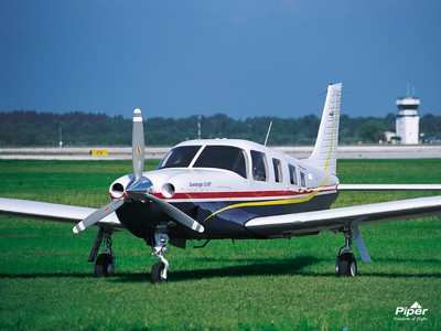
Piper PA-32R-300 File Photo
According to Lockheed Martin records, the pilot telephoned the
flight service station (FSS) on June 26 at 0815 and obtained a
weather briefing for the return flight to SUS. He did not file a
flight plan.
The pilot and his passengers were driven to the airstrip by a
Gaston employee. The employee said the passengers “wore
plastic bags on their feet” and “had luggage on their
laps.” He thought the airplane was “overloaded”
and the passengers “were tense, [but] maybe [it was] just the
heat.” They also appeared to be “in a hurry to
leave.” He said the engine “didn’t sound right
before takeoff,” and the airplane “didn’t appear
to lift very well.”
A Baxter County sheriff’s deputy took a recorded statement
from the passenger who was seated in the right front seat. He said
that just before takeoff, the pilot told him they were going to
need the entire runway. He said the airplane lifted off at the end
of the runway, dropped down into a shallow valley, touched the
ground, and lifted off again. It touched down a second time, hit a
tree, and “rolled” several times. He climbed over the
pilot (he said he could tell he was dead), got out of the airplane,
and went back to where his son was sitting. He said his son could
move but was “screaming in pain.”
One witness who observed the takeoff said the airplane
“came from runway with nose up (sic), possibly 30
percent,” and “was losing altitude.” Other
witnesses saw the airplane lift off and disappear into a shallow
valley. When it reappeared, it was in a slight climb, the wings
were "wig-wagging" and the airplane was "porpoising." A witness who
was fishing in a boat on the nearby White River said he heard the
airplane take off and could see it through the trees. He could tell
it “didn’t have much altitude.” Another witness
fishing on the river said the airplane “sounded like it was
barely moving. The plane was approximately 100 feet off the ground.
The plane veered to the right. The back of the plane hit a tree
(sheared left wing).”
The first 9-1-1 call was received at 0904.
Personnel (Crew) Information
The pilot, age 52, held a private pilot certificate with
airplane single-engine land and instrument ratings, dated April 22,
1992. He also held a third class airman medical certificate, dated
March 17, 2008, with no restrictions or limitations.
The second of the pilot’s two logbooks was recovered from
the wreckage. It contained entries October 18, 1993, to June 23,
2009, and indicated that the pilot had logged the following flight
times:
Total time, 673.8
Airplane single–engine land, 673.8
Piper PA-32R-300, 165.3
Pilot-in-command, 567.4
Dual instruction, 122.3
Cross-country, 512.9
Night, 71.3
Actual instruments, 100.1
Simulated instruments, 62.7
His most recent flight review was accomplished on March 20,
2009, in the accident airplane.
Aircraft Information
N38171 (s.n. 32R-7780392), and model PA-32R-300, was manufactured
by the Piper Aircraft Corporation in 1977, and was owned and
operated by PropAire, Inc., of St. Louis, Missouri. It was equipped
with a Lycoming IO-540-K1G5D engine (s.n. L-16598-48A), rated at
300 horsepower, driving a Hartzell 3-blade, all-metal,
constant-speed propeller (m.n. HC-C3YR-1RF).
According to the aircraft’s maintenance records, the last
annual and 100-hour inspections of the airframe, engine, and
propeller were accomplished on March 10, 2009, at a tachometer time
of 2,107.91 hours. At that time, the airframe total time was
9,011.45 hours, and the engine total time since new and since major
overhaul, which was done on May 11, 2000, was 8,390.50 hours and
2,107.91 hours, respectively. The propeller was overhauled on April
6, 1999, and dynamically balanced on February 24, 2004, at a
tachometer time of 1,015.17 hours. The last IFR certification of
the transponder, altimeter, encoder, and static system was on April
8, 2009.
Meteorolgical Information
The following Aviation Routine Weather Report (METAR) was recorded
at Ozark (Baxter County) Regional Airport (BPK), Mountain Home,
Arkansas, located 5 miles east of the accident site, at 0853:
Wind, calm; visibility, 6, haze; sky condition, clear;
temperature, 27 C.; dew point, 23 C.; altimeter setting, 29.91
inches of Mercury; Remarks: sea level pressure, 1011.6 mb.
The following Aviation Routine Weather Report (METAR) was
recorded at Marion County Regional Airport (FLP), Flippin,
Arkansas, located 5 miles south-southwest of the accident site:
Wind, calm; visibility, 10; sky condition, few clouds 6,000
feet; temperature, 28 degrees C.; dew point, 22 degrees C.;
altimeter setting, 29.91 inches of Mercury.
Witnesses described the weather at the time of take off as being
hot, hazy, and muggy.
Using the field elevation of 479 feet, a temperature and dew
point of 27 and 23 degrees C. (81 and 73 degrees F.), respectively,
and an altimeter setting of 29.91 inches of Mercury, the pressure
altitude was computed to be 489 feet, the density altitude was
calculated to be 2,367 feet, and the relative air density was
calculated to be 93.25 percent at takeoff from Gaston’s.
Aerodrome Information
Gaston’s Airstrip (3MO) is located one mile south of
Lakeview at coordinates 36 degrees, 20.55’ north latitude,
and 092 degrees, 33.25’ west longitude. It is situated at an
elevation of 479 feet msl. It has one runway: 06-24, 3,200 feet x
55 feet, turf. The grass runway was well manicured. The height of
the grass on the runway was approximately 1 inch.
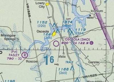
3MO Sectional
Wreckage and Impact Information
The on-site investigation commenced June 27 and terminated June 28,
2009.
The compass heading for runway 6 was 069 degrees and was 0.6
miles long (as measured by automobile odometer). The airplane
wreckage was measured to be 0.7 miles past the end of the
runway.
Examination of the accident site disclosed tire tracks in the
tall grass, on a magnetic heading of 120 degrees, leading up to a
barbed wire fence that had been torn down. Just beyond the fence
was a large tree with chop marks consistent with propeller strikes.
Most of the bark was missing. At the base of this tree were the
airplane’s left wing and left rear cargo door. Beyond the
tree, on a heading of 128 degrees and twisting to a heading of 179
degrees, was the twisted airplane wreckage. The nose was aligned on
a heading of 097 degrees and the tail was aligned on a heading of
031 degrees, magnetic. Numerous personal effects were found
scattered on the ground.
The fuel selector was photographed and compared with an
exemplar. It was determined that it was positioned on the left main
tank. The landing gear control was in the DOWN position, and the
bellcrank was extended. The flap handle lay flat on the floor, and
the actuator was in the UP position. Examination of the elevator
trim jackscrew revealed 8 threads exposed. According to the Piper
Aircraft representative, 0 threads equates to FULL NOSE DOWN, 5
threads equates to the NEUTRAL position, and 16 threads equates to
FULL NOSE UP. The ELT (emergency locator transmitter) was found
ARMED with a battery expiration date of June 2010. Further
examination of the cockpit disclosed the following:
Alternate Air – CLOSED
Suction – 0
Autopilot – OFF
Door Seals – ON
Backup Radio Master – ON
Guard – OFF
Attitude Gyro Switch – ON
Guard – ON
Outside Air Temperature – 9 degrees F. (15 degrees C.)
Master Switch – OFF
Fuel Pump – OFF
Anti-Collision Light – OFF
Landing Light – OFF
Pitot Heat – OFF
Airspeed Indicator – 0
No. 1 Artificial Gyro Horizon – Inverted, 15 degrees left
bank/30 degrees nose up
No. 2 Artificial Gyro Horizon – 90 degrees left bank
Directional Gyro – 255 degrees
Altimeter – 800 feet, 29.90 inches of Mercury
Vertical Speed – 500 fpm, UP
No. 1 OBS – 030 degrees
No. 2 OBS – 120 degrees
Left/Right Fuel – 0
Fuel Pressure – 0
Manifold Pressure – 30 inches of Mercury
Fuel Flow – 0
Magnetos – BOTH
ADF – 355 degrees HEADING, 085 degrees BEARING, 227kHz
Transponder – 1200 Mode C
Examination of the engine revealed oil in the crankcase. Thumb
compression was obtained on all cylinders. The spark plugs were of
normal coloration, and the fuel screen and servo and oil filter
were clean. Both magnetos produced spark when turned by hand. All
three propeller blades were bent aft midspan, and the tips were
curled forward. There were 90-degree chordwise scratches on the
cambered surfaces of all the blades,
Tests and Research
Attached to the airplane’s instrument panel was a Garmin 496
Global Positioning System (GPS) receiver. It had the capability of
recording and saving flight data on a memory chip. The receiver was
sent to NTSB’s Vehicle Recorder Laboratory in Washington, DC,
for download. Attached to this report are pictorial representations
of the accident flight. Below is the data from the accident
flight:
Position Time Altitude Length Time Speed Course
N36 20.884 W92 33.627 09:55:52 573 ft
N36 20.881 W92 33.628 09:59:11 500 ft 13 ft 0:03:19 0 mph
193°
N36 20.874 W92 33.648 09:59:26 499 ft 112 ft 0:00:15 5 mph
246°
N36 20.856 W92 33.659 09:59:39 496 ft 124 ft 0:00:13 7 mph
206°
N36 20.854 W92 33.654 09:59:51 494 ft 31 ft 0:00:12 2 mph
111°
N36 20.855 W92 33.655 10:03:43 492 ft 9 ft 0:03:52 0 mph
329°
N36 20.858 W92 33.637 10:04:01 497 ft 88 ft 0:00:18 3 mph
077°
N36.20.872 W92 33.583 10:04:07 497 ft 279 ft 0:00:06 32 mph
073°
N36.20.903 W92 33.485 10:04:14 494 ft 514 ft 0:00:07 50 mph
068°
N36.20.953 W92 33.342 10:04:22 496 ft 0.1 mi 0:00:08 65 mph
067°
N36.21.011 W92 33.156 10:04:31 194 ft 0.2 mi 0:00:09 74 mph
069°
N36 21.071 W92 32.961 10:04:40 508 ft 0.2 mi 0:00:09 78 mph
069°
N36.21.121 W92 32.786 10:04:48 508 ft 0.2 mi 0:00:08 77 mph
070°
N36.21.133 W92 32.720 10:04:51 507 ft 333 ft 0:00:03 76 mph
077°
N36.21.124 W92 32.536 10:04:59 497 ft 0.2 mi 0:00:08 77 mph
094°
N36.21.086 W92 32.368 10:05:07 497 ft 0.2 mi 0:00:08 73 mph
106°
NOTE: The time of the receipt of the first 9-1-1 call is
slightly different than the recorded GPS times.
Weight and Balance computations:
Basic Empty Weight 1/ 2,281 X = 188,137.42
Pilot and Front Passenger 2/ 397 X 85.5 = 33,943.50
Passengers (Center Seat, Aft Facing) 2/ 332 X 119.1 =
39,541.20
Passengers (Rear Seats) 2/ 143 X 157.6 = 22,536.80
Fuel (94 gal maximum) 3/ 564 X 93.6 = 52,790.40
Baggage (forward) 4/ 60 X 42.0 = 2,520.00
Baggage (aft) 4/ 79 X 178.7 = 14,117.30
Baggage 5/ 88 X 157.6 = 13,868.80
Takeoff weight from SUS 3,944 367,455.42
Maximum gross weight 3,600
Overweight at SUS takeoff 344
c.g. at takeoff from SUS 367,455.42/3944 = 93.17 in.
c.g. envelope = 91.4 in. FWD limit, 95 in. AFT limit
1/ Weight and Balance Revision, dated March 3, 2007
2/ Coroner’s Report: (LF) W. Langford, 197
(RF) D. Berkerle, 200
(LC) J. Ritz, 182
(RC) D. Berkerle, 150
(LR) D. Langford, 143
3/ 6 pounds/gallon, topped off prior to departure from SUS
4/ Baxter County Sheriff (88 pounds of scattered personal effects
were collected and weighed)
5/ It is not known where the miscellaneous 88 pounds of personal
effects were stored. These were the items scattered at the accident
site and collected by the sheriff’s department. For
computational purposes, they have been assigned the empty right
rear seat arm (157.6).
According to PropAire’s maintenance officer, club members
flight plan for 16 gallons per hour and 5 gallons for takeoff and
climb. This equates to roughly 26 gallons (1.3 X 16 = 20.8 + 5 =
25.5) of fuel consumed on the flight from SUS.
Basic Empty Weight 2,281 X = 188,137.42
Pilot and Front Passenger 397 X 85.5 = 33,943.50
Passengers (Center Seat, Aft Facing) 332 X 119.1 = 39,541.20
Passengers (Rear Seats) 143 X 157.6 = 22,536.80
Fuel (68 gal) 408 X 93.6 = 38,188.80
Baggage (forward) 60 X 42.0 = 2,520.00
Baggage (aft) 79 X 178.7 = 14,117.30
Baggage 88 X 157.6 = 13,868.80
Takeoff weight from SUS 3,788 352,853.82
Maximum gross weight 3,600
Overweight at Gaston’s takeoff 188
c.g. at takeoff from Gaston’s 352,853.82/3788 = 93.15 in.
The performance charts found in the Pilot’s Operating
Handbook were consulted. Based on a gross weight of 3,000 pounds,
the computed flaps-up takeoff ground roll (paved, level, dry
runway) would be approximately 1,700 feet, and the computed
flaps-up takeoff distance over a 50-foot barrier (paved, level, dry
runway) would be approximately 2,900 feet. According to PropAire,
members assess 10 per cent (short grass) and 20 per cent (long
grass) performance penalties when computing takeoff distances on
grass or turf runways. Using these performance penalties, the
computed flaps-up takeoff ground roll would be approximately 1,870
feet, and the computed flaps-up takeoff distance over a 50-foot
barrier would be approximately 3,190 feet.
Using 25° of flaps for takeoff, the computed takeoff ground
roll (paved, level, dry runway) would be approximately 1,210 feet,
and the computed takeoff distance over a 50-foot barrier (paved,
level, dry runway) would be approximately 1,700 feet. Applying the
10 per cent performance penalty, the computed takeoff ground roll
and takeoff distance over a 50-foot barrier from a short grass
runway would be 1,331 feet and 1,870 feet, respectively. The runway
at Gaston’s was 3,200 feet long.
It was noted that Section 5, “Performance,” of the
Piper PA-32R-300 Pilot’s Operating Handbook (p. 5-1,
excerpted) states: “The performance charts are unfactored
(sic) and do not make any allowance for varying degrees of pilot
proficiency or mechanical deterioration of the aircraft. Effects of
conditions not considered on the charts must be evaluated by the
pilot, such as the effect of soft or grass runway surface on
takeoff and landing performance. WARNING: Performance information
derived by extrapolation beyond the limits of the charts should not
be used for flight planning purposes.”
Additional Information
A guest at Gaston’s videotaped the takeoff and the footage
was made available to NTSB. According to the videotape, the nose
wheel came off the ground as the airplane was approximately
one-third down the runway. It maintained this attitude throughout
the takeoff roll and lifted off at the end of the runway. At that
point, the runway dropped off and the airplane disappeared from
sight. Moments later it reappeared, still in a nose high attitude,
and the wings were “wig-wagging.”
The videotape was reviewed by PropAire officials. The following
is an excerpt from their correspondence: “Based on reports of
4-6" grass, [the pilot’s] only hope to achieve takeoff speed
would have been to keep the nose on the runway for almost 3/4ths of
the runway length. With a nose high attitude, he actually never
achieved flying speed, as evidenced by the speeds recorded by the
[Garmin GPS] 496. His continuation of the takeoff put him on the
back side of the power curve, 'hanging on the prop' in ground
effect.
“Based on the video, he was either trying to horse it off
the ground and most likely [panicked] at that point (about mid
field), or the airplane itself may have contributed to the pitch up
moment given the overweight and aft CG.”
 ANN's Daily Aero-Linx (04.13.24)

