One Of Three Tests In The IMAGES Program
 Signals mimicking those coming from a future European
satellite system have been successfully tested by Eurocopter and
Funkwerk Avionics with a helicopter test flight using an EC145
equipped with the Galileo test bed GATE. The test took place in
Berchtesgaden, Southern Germany. The test flight was observed by
IFEN GmbH, the operator of the GATE test bed. The test marked the
first time that signals from the future European satellite
navigation system Galileo were used for navigation in a helicopter.
In the “Galileo Test and Development Environment”
(GATE), transmission antennas on six mountain peaks simulate the
Galileo signals. In recent months, these so-called
“pseudolites” had been upgraded to the current Galileo
signal definition.
Signals mimicking those coming from a future European
satellite system have been successfully tested by Eurocopter and
Funkwerk Avionics with a helicopter test flight using an EC145
equipped with the Galileo test bed GATE. The test took place in
Berchtesgaden, Southern Germany. The test flight was observed by
IFEN GmbH, the operator of the GATE test bed. The test marked the
first time that signals from the future European satellite
navigation system Galileo were used for navigation in a helicopter.
In the “Galileo Test and Development Environment”
(GATE), transmission antennas on six mountain peaks simulate the
Galileo signals. In recent months, these so-called
“pseudolites” had been upgraded to the current Galileo
signal definition.
The test flight was one of three demonstration campaigns as part
of the European research project MAGES. MAGES stands for Mature
Applications of Galileo for Emergency Services and is a project
funded by the Galileo Supervisory Authority (GSA), which aims to
demonstrate the benefits of EGNOS and Galileo for emergency
services.
For helicopter air rescue services Galileo could one day lead to
a paradigm shift, as there would then be an additional satellite
navigation system, independent of (although compatible with) the
American Navstar GPS available, which would also, as part of the
Safety Of Life Service, provide information on the reliability of
the signal. This could, in combination with highly reliable terrain
data and obstacle detection system as well as up-to-the-minute
traffic data allow for the development of new flight procedures,
which would permit rescue helicopters to achieve field landings
nearby the accident site, even in bad weather conditions. At
present, such landings at not previously identified sites are only
possible under visual meteorological conditions.
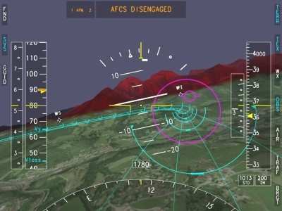
During the test flight in Berchtesgaden the test pilot in the
cockpit of the EC145 experimental helicopter used a synthetic
vision system developed by Eurocopter, on which the terrain below
and around the helicopter is shown in perspective. The positioning
of the synthetic terrain displayed is based on the data from the
Galileo satellite navigation system. As an additional navigational
aid, the pilot was also provided with a special
“tunnel-in-the-sky” symbology for the planned flight
path, which led him safely through the mountainous terrain to its
landing site.
As part of the test flight an “integrity alarm”, on
which one of the simulated Galileo satellites was marked as having
failed, was also demonstrated. In future, this “integrity
information” would make it possible for a suitable navigation
system to warn the pilot that continuing the flight may be unsafe
if the navigation provided by Galileo can no longer be guaranteed
to be reliable.
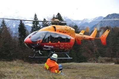
During the test flight it was also possible to demonstrate other
innovative solutions to existing problems. For example, the
helicopter crew was able to fly straight to an
“injured” fireman and “rescue” him thanks
to a transponder, powered with rechargeable batteries, which
allowed his position to be displayed on the navigation
system’s screen in the helicopter. The system demonstrated is
based on transponder technology developed by Funkwerk Avionics. The
ADS-B transponder used by the system determines its current
position via GPS and transmits this information continuously
(“ADS-B out”). The receiver located on board the
helicopter receives these signals (“ADS-B in”) and
sends them to the helicopter’s navigation system, where the
position is displayed on the basis of the data received.
In the next stage of this process, these signals could then also
be transmitted to a ground station, but this was not demonstrated
during this flight. One advantage of this system is that it
operates without the need for any ground infrastructure, such as a
GSM network, as such infrastructure is not available everywhere, on
the one hand (for example, when fighting forest fires in remote
locations), or may be destroyed by the event itself. The ADS-B
system was originally developed for use in air space surveillance,
but has also proven its worth in various applications such as for
monitoring ground vehicle movements (for example, at airports).
 ANN's Daily Aero-Linx (04.15.24)

