Honeywell Sentinel Display Enhanced With Approach Plates, Airport Diagrams | Aero-News Network
Aero-News Network
RSS icon RSS feed
podcast icon MP3 podcast
Subscribe Aero-News e-mail Newsletter Subscribe

Airborne Unlimited -- Most Recent Daily Episodes

Episode Date

Airborne-Monday

Airborne-Tuesday

Airborne-Wednesday Airborne-Thursday

Airborne-Friday

Airborne On YouTube

Airborne-Unlimited-04.01.24

Airborne-Unlimited-04.16.24

Airborne-FlightTraining-04.17.24 Airborne-Unlimited-04.11.24

Airborne-Unlimited-04.12.24

Join Us At 0900ET, Friday, 4/10, for the LIVE Morning Brief.
Watch It LIVE at
www.airborne-live.net

Tue, Feb 23, 2010

Honeywell Sentinel Display Enhanced With Approach Plates, Airport Diagrams

Other New Features Include Flexible Mounting And Shipping Symbology From Maritime Transponders

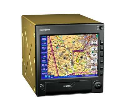
Honeywell says it has upgraded its Sentinel Multi-Function Display and Navigation System to include a new display for improved cockpit flexibility and new software features to improve the system capability, as well as approach plates and airport diagrams. The company made the announcement Sunday at Heli-Expo 2010.

"Helicopter pilots appreciate the safety and situational awareness the Sentinel brings to their operations, especially for helicopter emergency service (HEMS)," said Chad Cundiff, vice president, Crew Interface and Displays, Honeywell Aerospace. "The approach plates and airport diagrams will simplify their flights since they can fly without manually changing charts as they fly."

North American Sentinel customers can get geo-referenced approach plates and airport diagrams directly from Seattle Avionics Software, a leading provider of aviation software and digital ChartData. Other regions will have access to similar aviation charts through a future upgrade.

The new remote-mount display is a slim-line 5.7-inch screen package that allows operators with little cockpit space to utilize the Sentinel system without removing any avionics. The display can be mounted either in portrait or landscape modes, depending on the operator's needs.

Honeywell Sentinel MFD

"The Sentinel is designed specifically to meet safety needs of helicopter operators," said Cundiff. "Not only does it add situational awareness for less than $10,000, but it includes terrain mapping, intelligent database search engine, traffic, weather, Automatic Identification System (AIS) transponder display and VFR navigation."

For helicopter operators that fly in littoral areas, shipping symbology has been added via a new maritime AIS transponder interface. Sentinel can display external camera images for pilots with hoist or enhanced vision systems, for example.

Designed to support private, executive, medical evacuation, air ambulance, civil and military reconnaissance roles, Sentinel is a price-competitive package providing high-resolution mapping and multiple sensor interfaces. It starts at $9,995 and is available for use in Europe or North America. The upgrade will be available second quarter from any Honeywell authorized sales and service center.

FMI: www.honeywell.com

Advertisement

More News

ANN's Daily Aero-Linx (04.15.24)

Aero Linx: International Flying Farmers IFF is a not-for-profit organization started in 1944 by farmers who were also private pilots. We have members all across the United States a>[...]

Classic Aero-TV: 'No Other Options' -- The Israeli Air Force's Danny Shapira

From 2017 (YouTube Version): Remembrances Of An Israeli Air Force Test Pilot Early in 2016, ANN contributor Maxine Scheer traveled to Israel, where she had the opportunity to sit d>[...]

Aero-News: Quote of the Day (04.15.24)

"We renegotiated what our debt restructuring is on a lot of our debts, mostly with the family. Those debts are going to be converted into equity..." Source: Excerpts from a short v>[...]

Airborne 04.16.24: RV Update, Affordable Flying Expo, Diamond Lil

Also: B-29 Superfortress Reunion, FAA Wants Controllers, Spirit Airlines Pulls Back, Gogo Galileo Van's Aircraft posted a short video recapping the goings-on around their reorganiz>[...]

ANN's Daily Aero-Term (04.16.24): Chart Supplement US

Chart Supplement US A flight information publication designed for use with appropriate IFR or VFR charts which contains data on all airports, seaplane bases, and heliports open to >[...]

blog comments powered by Disqus


Advertisement

Advertisement

Podcasts

Advertisement

© 2007 - 2024 Web Development & Design by Pauli Systems, LC