Eurocopter AS350/355 Receive Chelton Software Upgrade | Aero-News Network
Aero-News Network
RSS icon RSS feed
podcast icon MP3 podcast
Subscribe Aero-News e-mail Newsletter Subscribe

Airborne Unlimited -- Most Recent Daily Episodes

Episode Date

Airborne-Monday

Airborne-Tuesday

Airborne-Wednesday Airborne-Thursday

Airborne-Friday

Airborne On YouTube

Airborne-Unlimited-04.01.24

Airborne-Unlimited-04.09.24

Airborne-Unlimited-04.10.24 Airborne-Unlimited-04.11.24

Airborne-Unlimited-04.12.24

Join Us At 0900ET, Friday, 4/10, for the LIVE Morning Brief.
Watch It LIVE at
www.airborne-live.net

Wed, Apr 09, 2008

Eurocopter AS350/355 Receive Chelton Software Upgrade

6.0B Earns Additional STC Approval

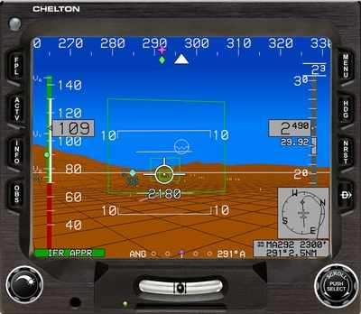
The Chelton Flight Systems Organization Designation Authorization (ODA) recently approved the amendment to Supplemental Type Certificate (STC) SR02230AK-D, allowing software version 6.0B to be run on Chelton’s Synthetic Vision EFIS displays in Eurocopter models AS350 and AS355. 6.0B was TSO'd in December 2007 and is DO-178B Level-A certified.

Over 40 significant benefits are available for end-users, including:

  • ADS-B datalink display functions, including TIS-B (traffic) and FIS-B (flight information, including weather)
  • WSI Weather. Supported products include NEXRAD Weather Radar, Echo Tops, Graphical METARs, Textual METARs, Textual TAFs, Lightning, SIGMETs/AIRMETs, TFRs, and Winds/Temps aloft
  • Holding Patterns may be created at any fix or waypoint; entries are calculated automatically
  • Nearest ILS Approaches. One touch activates an ILS approach, sets the inbound OBS course, and sends the ILS frequency to a remotely-tuned NAV radio
  • Enhanced FMS Capability including vertical navigation (VNAV) and waypoint offsets
  • Vertical Deviation Indicator for RNAV Approaches and enroute VNAV capability
  • Expanded Hover Vector for Helicopters displayed with large radar altitude scale on MFD
  • Autopilot Mode Source Annunciation for use with existing legacy analog autopilots
  • Shaded Relief Terrain Depiction on MFD resembling a satellite image
  • TCAS-II interface and resolution advisory symbology
  • Basic ADI Mode for transition and training
  • FMS-Style Navigation Log for easy preview of procedures

"We’re proud to have achieved this milestone with the Eurocopter models. Software 6.0B truly represents state-of-the-art functionality and will make the AS350/355 flight management experience safer and more intuitive," said Chelton General Manager Jim Shirey.

In addition to STC SR02230AK-D, 6.0B is also available for new EFIS installations or as an upgrade to existing EFIS displays under STC SA02203AK Part 23 AML (400+ fixed wing aircraft models). 6.0B will also be available for EFIS installations with Mod 1 memory module upgrade as the software is added under the STC approval.

Software 6.0B supports the architecture requirements for Part-25 airplanes and IFR helicopters, opening the door for these approvals in the second half of 2008.

FMI: www.cheltonflightsystems.com

Advertisement

More News

ANN's Daily Aero-Linx (04.13.24)

Aero Linx: Florida Antique Biplane Association "Biplanes.....outrageous fun since 1903." That quote really defines what the Florida Antique Biplane Association (FABA) is all about.>[...]

ANN's Daily Aero-Term (04.13.24): Beyond Visual Line Of Sight (BVLOS)

Beyond Visual Line Of Sight (BVLOS) The operation of a UAS beyond the visual capability of the flight crew members (i.e., remote pilot in command [RPIC], the person manipulating th>[...]

Airborne 04.09.24: SnF24!, Piper-DeltaHawk!, Fisher Update, Junkers

Also: ForeFlight Upgrades, Cicare USA, Vittorazi Engines, EarthX We have a number of late-breaking news highlights from the 2024 Innovation Preview... which was PACKED with real ne>[...]

Aero-News: Quote of the Day (04.14.24)

“For Montaer Aircraft it is a very prudent move to incorporate such reliable institution as Ocala Aviation, with the background of decades in training experience and aviation>[...]

ANN's Daily Aero-Term (04.14.24): Maximum Authorized Altitude

Maximum Authorized Altitude A published altitude representing the maximum usable altitude or flight level for an airspace structure or route segment. It is the highest altitude on >[...]

blog comments powered by Disqus


Advertisement

Advertisement

Podcasts

Advertisement

© 2007 - 2024 Web Development & Design by Pauli Systems, LC