Global Emergency Aircraft Locating Service Provides Critical, On-Demand Data To Aviation Stakeholders As A Public Service
The Irish Aviation Authority (IAA) and Aireon have announced that the Aireon Aircraft Location and Emergency Response Tracking (ALERT) service is officially live.
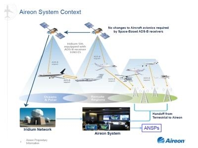
As the first system of its kind in public service, Aireon ALERT provides Air Navigation Service Providers (ANSPs), commercial aircraft operators/airlines, aviation regulators and search and rescue organizations with the last known position of any Automatic Dependent Surveillance-Broadcast (ADS-B) equipped aircraft globally. Much of the world's aircraft are already fitted with this technology, and it will allow for identification of an accurate position for an aircraft that is in an apparent state of distress or experiencing a loss in communication.
Operated by the IAA out of their North Atlantic Communications Centre in Ballygirreen, County Clare, Ireland, Aireon ALERT is enabled by the Aireon system, the world's first global air traffic surveillance service. The system, which went live on 2 April 2019, monitors all ADS-B-equipped aircraft spanning the entirety of the earth's surface—even over the ocean and in the most remote airspaces. Prior to Aireon becoming operational, only 30 percent of the Earth's surface was monitored through conventional ground systems, leaving over 70 percent without any real-time air traffic surveillance. With Aireon ALERT, registered users now have access to exact location information for aircraft in distress, on-demand, which will dramatically benefit global emergency response efforts.
"This is an exciting day for the IAA and Aireon teams," said Peter Kearney, CEO of IAA. "We have been preparing for this moment for a long time, and we are proud to host and operate the world's first global aircraft locating system. The IAA has always been about innovation and service excellence; our position as a partner in Aireon and in the provision of this global service, further strengthens Ireland's role as a key player in the global aviation industry. As of now, our facility in Ballygirreen is providing the Aireon ALERT service every day, no matter the hour, and we are excited to play such a critical role in delivering this game-changing service to the aviation community. Building on our role as a key player in communications for the North Atlantic, we are proud to be powering Aireon ALERT for the entire globe."
"Now that the Aireon system is operational, we are thrilled to deliver this much-needed public service to the industry," said Don Thoma, CEO of Aireon. "Aireon ALERT can provide the most accurate and precise aircraft locating data for emergency and distress situations, free of charge. As the operator of the world's only global aircraft surveillance system, we recognize our unique position to provide such a critical service to the aviation community, and see it as our duty to provide this data to the proper authorities to assist in emergency situations."
Aireon ALERT users do not need to be customers of Aireon or the IAA to access the service; however it is important that all commercial aircraft operators/airlines, aviation regulators and search and rescue organizations register to ensure they can contact the 24/7/365 operations facility, in the event of an emergency, to obtain the last known position of its aircraft. Once contacted, the Aireon ALERT operator will provide a map of the last 15 minutes of flight for the particular aircraft in distress, with one plot per minute and a 4-dimensional report including altitude, latitude, longitude and time information.
(Source: Aireon news release. Image from file)
 ANN's Daily Aero-Linx (04.13.24)

