NASA Spacecraft Images Offer Sharper Views Of Apollo Landing Sites | Aero-News Network
Aero-News Network
RSS icon RSS feed
podcast icon MP3 podcast
Subscribe Aero-News e-mail Newsletter Subscribe

Airborne Unlimited -- Most Recent Daily Episodes

Episode Date

Airborne-Monday

Airborne-Tuesday

Airborne-Wednesday Airborne-Thursday

Airborne-Friday

Airborne On YouTube

Airborne-Unlimited-04.01.24

Airborne-Unlimited-04.16.24

Airborne-FlightTraining-04.17.24 Airborne-Unlimited-04.11.24

Airborne-Unlimited-04.12.24

Join Us At 0900ET, Friday, 4/10, for the LIVE Morning Brief.
Watch It LIVE at
www.airborne-live.net

Thu, Sep 08, 2011

NASA Spacecraft Images Offer Sharper Views Of Apollo Landing Sites

Photographs Show Tracks Made My Astronauts, Rovers

NASA's Lunar Reconnaissance Orbiter (LRO) captured the sharpest images ever taken from space of the Apollo 12, 14 and 17 landing sites. Images show the twists and turns of the paths made when the astronauts explored the lunar surface.

Apollo 17 Site NASA Image

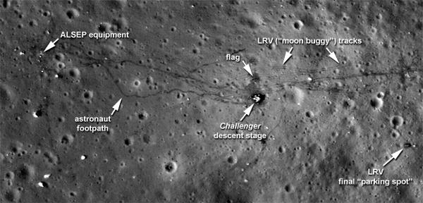
At the Apollo 17 site, the tracks laid down by the lunar rover are clearly visible, along with the last foot trails left on the moon. The images also show where the astronauts placed some of the scientific instruments that provided the first insight into the moon's environment and interior. "We can retrace the astronauts' steps with greater clarity to see where they took lunar samples," said Noah Petro, a lunar geologist at NASA's Goddard Space Flight Center in Greenbelt, Md., who is a member of the LRO project science team.

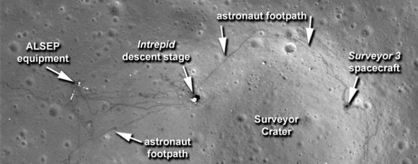
All three images show distinct trails left in the moon's thin soil when the astronauts exited the lunar modules and explored on foot. In the Apollo 17 image, the foot trails, including the last path made on the moon by humans, are easily distinguished from the dual tracks left by the lunar rover, which remains parked east of the lander. "The new low-altitude Narrow Angle Camera images sharpen our view of the moon's surface," said Arizona State University researcher Mark Robinson, principal investigator for the Lunar Reconnaissance Orbiter Camera (LROC). "A great example is the sharpness of the rover tracks at the Apollo 17 site. In previous images the rover tracks were visible, but now they are sharp parallel lines on the surface."

At each site, trails also run to the west of the landers, where the astronauts placed the Apollo Lunar Surface Experiments Package (ALSEP) to monitor the moon's environment and interior.

Apollo 12 Site NASA Image

This equipment was a key part of every Apollo mission. It provided the first insights into the moon's internal structure, measurements of the lunar surface pressure and the composition of its atmosphere. Apollo 11 carried a simpler version of the science package. One of the details that shows up is a bright L-shape in the Apollo 12 image. It marks the locations of cables running from ALSEP's central station to two of its instruments. Although the cables are much too small for direct viewing, they show up because they reflect light very well.

The higher resolution of these images is possible because of adjustments made to LRO's orbit, which is slightly oval-shaped or elliptical. "Without changing the average altitude, we made the orbit more elliptical, so the lowest part of the orbit is on the sunlit side of the moon," said Goddard's John Keller, deputy LRO project scientist. "This put LRO in a perfect position to take these new pictures of the surface."

The maneuver lowered LRO from its usual altitude of approximately 31 miles (50 kilometers) to an altitude that dipped as low as nearly 13 miles (21 kilometers) as it passed over the moon's surface. The spacecraft has remained in this orbit for 28 days, long enough for the moon to completely rotate. This allows full coverage of the surface by LROC's Wide Angle Camera. The cycle ended Wednesday when the spacecraft was returned to its 31-mile orbit.

FMI: www.nasa.gov
 

Advertisement

More News

ANN's Daily Aero-Linx (04.15.24)

Aero Linx: International Flying Farmers IFF is a not-for-profit organization started in 1944 by farmers who were also private pilots. We have members all across the United States a>[...]

Classic Aero-TV: 'No Other Options' -- The Israeli Air Force's Danny Shapira

From 2017 (YouTube Version): Remembrances Of An Israeli Air Force Test Pilot Early in 2016, ANN contributor Maxine Scheer traveled to Israel, where she had the opportunity to sit d>[...]

Aero-News: Quote of the Day (04.15.24)

"We renegotiated what our debt restructuring is on a lot of our debts, mostly with the family. Those debts are going to be converted into equity..." Source: Excerpts from a short v>[...]

Airborne 04.16.24: RV Update, Affordable Flying Expo, Diamond Lil

Also: B-29 Superfortress Reunion, FAA Wants Controllers, Spirit Airlines Pulls Back, Gogo Galileo Van's Aircraft posted a short video recapping the goings-on around their reorganiz>[...]

ANN's Daily Aero-Term (04.16.24): Chart Supplement US

Chart Supplement US A flight information publication designed for use with appropriate IFR or VFR charts which contains data on all airports, seaplane bases, and heliports open to >[...]

blog comments powered by Disqus


Advertisement

Advertisement

Podcasts

Advertisement

© 2007 - 2024 Web Development & Design by Pauli Systems, LC