Into The Cradle Of Thunder
NASA hurricane researchers are deploying to Costa Rica next
month to investigate the birthplace of eastern Pacific tropical
cyclones. They will be searching for clues that could lead to a
greater understanding and better predictability of one of the
world's most significant weather events -- the hurricane.
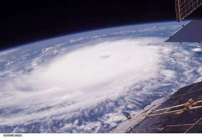
As scientists and residents on many coasts brace for another
potentially challenging hurricane season, NASA is launching the
Tropical Cloud Systems and Processes (TCSP) mission. TCSP is a
month-long research effort primarily intended to document
"cyclogenesis," the birth of tropical storms, hurricanes and
related phenomena.
Researchers will monitor oceanic thunderstorms to study why some
systems develop into tropical cyclones and some do not. Researchers
feel the data is vital to understanding how such weather systems
evolve and travel. The data also could support development of a
more accurate and timely warning system to help safeguard property
and lives.
A team of atmospheric scientists, engineers and aircraft
personnel will take up residence in San Jose, Costa Rica during
July. The NASA team will work with the National Oceanic and
Atmospheric Administration (NOAA) and Costa Rican Centro Nacional
de Alta Tecnologia (CENAT). The team will conduct ground-based and
airborne studies to measure the buildup and behavior of tropical
storm systems on Costa Rica's east and west coasts.
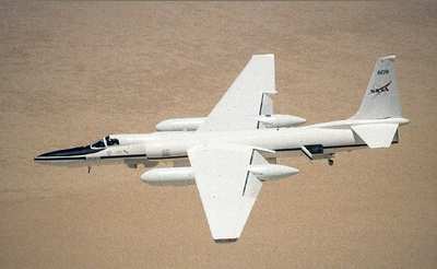
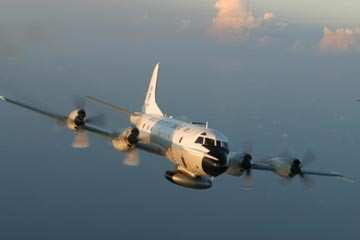
Missions will be flown over the region using NASA's ER-2 and
NOAA's WP-3D Orion aircraft and with unmanned aerial vehicles
(aerosondes). The unmanned flights will be managed in conjunction
with the University of Colorado at Boulder. The airborne
experiments will collect temperature, humidity, precipitation, and
wind information related to tropical cyclones and other phenomena
that often lead to development of more powerful storms at sea. The
field operations will also take advantage of several NASA and NOAA
satellites.
NASA and the Instituto Meteorologico Nacional of Costa Rica also
will launch a series of RS-92 series, balloon-borne probes
(sondes), to measure humidity and other data related to tropical
storm origins.
"Costa Rica is an ideal location for this research," said Dr.
Ramesh Kakar, Weather Focus Area leader for NASA's Science Mission
Directorate. A vast number of tropical storms and hurricanes
impacting the eastern Pacific are spawned near the small Central
American nation's western coast.
"In the Atlantic, cyclogenesis often occurs off the western
coast of Africa, or sufficiently far out over the ocean that
long-duration science flights are extremely difficult," Kakar said.
"In the eastern Pacific near Costa Rica, however, it is possible to
study the genesis process from formation of the initial disturbance
until, in some cases, it grows into a hurricane over a more compact
geographical region."
Researchers also will be able to take advantage of their
proximity to the Caribbean and the western Gulf of Mexico, studying
tropical systems off Costa Rica's eastern shores during more mature
phases of development.
"This experiment is significant for two reasons," said Robbie
Hood, an atmospheric scientist at the Marshall Space Flight Center,
Huntsville, AL. She is one of three lead scientists for the project
in Costa Rica. "We will have an opportunity to take a closer look
at the factors contributing to the initiation and intensification
of tropical cyclones which are still somewhat mysterious processes
for researchers and operational forecasters. We will also be
examining the best combinations of satellite and aircraft
technologies to improve how hurricanes are monitored and
predicted," she said.
"Building on a quarter-century of ever-improving spaceborne
observations of the Earth, we are entering an exciting new era,
using information collected by satellites and uninhabited aerial
vehicles to the best advantage for improved weather prediction and
other societal benefits," Hood said.
The new study continues NASA's successful Convection and
Moisture Experiment
(CAMEX) research series, conducted from 1998 to 2001 with NOAA.
TCSP participants include NOAA's Hurricane Research Division, five
NASA centers, 10 American universities and partner agencies in
Costa Rica.
 ANN's Daily Aero-Linx (04.15.24)

