Probable Cause Report Expected Later This Week
The NTSB has released a factual report from a September, 2010 accident near Mountain View, AR, which resulted in the fatal injury of two people after the airplane, a Cessna 210, reportedly broke up in flight. Witnesses told the board one wing of the airplane "folded" as it spun towards the ground, and the left wing was found about a quarter mile from the main wreckage. The report indicates there were no known mechanical issues with the airplane prior to the accident flight.

According to the report, on September 7, 2010, about 1320 CDT, a Cessna T210N, single-engine airplane, N2081U, sustained substantial damage following an in-flight break up and subsequent impact with trees and terrain near Mountain Home, Arkansas. The private pilot and pilot-rated passenger on board the airplane were fatally injured. The airplane was registered to and operated by Monterey Bay Aviation, Incorporated, Watsonville, California. No flight plan was filed for the 14 Code of Federal Regulations, Part 91 personal flight; however, the pilot was receiving radar flight following from the Memphis Air Route Traffic Control Center (ARTCC). The cross-country flight originated at Vermilion Regional airport, Danville, Illinois, about 0930 and was en route to Georgetown, Texas.
The pilot contacted Memphis ARTCC at 1245. The controller queried if the pilot could see the precipitation around the Flippin (FLP) VOR. The pilot replied “Roger.” The airplane was flying on about a 235 degree heading at an altitude of 6,700 feet mean sea level (msl).
At 1305, Memphis ARTCC told the pilot that there was a “very large area” of precipitation 30 miles ahead of him that extended south of Fort Smith Arkansas. The controlled added that it was “a very, very large area [of] moderate to heavy precipitation.” At 1307, the pilot was directed to another frequency. The pilot checked in with Memphis ARTCC on the new assigned frequency. The pilot was given the current Mountain Home, Arkansas altimeter setting and was informed that weather radar was depicting an area of heavy to extreme precipitation 15 miles ahead of the pilot along his route of flight for the next 180 miles. The pilot responded with, “Thank you.”
At 1317, the pilot requested a descent to 4,500 feet “for VFR” (Visual Flight Rules flight). The control cleared the pilot to “maintain VFR” and would let the pilot know when he lost him on the controller’s radar. At 1318:51, the airplane initiated a left turn to a heading of about 160 degrees. Two minutes later the airplane made a right turn back to toward the southwest. The turn continued until radar contact was lost at 1320:40. The airplane was at 7 nautical miles south of FLP at 6,600 feet msl when radar contact was lost.
At 1322, the controller broadcast to the pilot that he’d lost the airplane on radar. The pilot did not respond. Memphis made several attempts to contact the pilot. The pilot did not respond to any of them.
According to witnesses in the area, the airplane’s engine could be heard “revving up and down” but the airplane could not be seen because of an overcast layer of clouds. Moments later the airplane appeared from the clouds and was observed descending in a nose down spiral. The witnesses added that before the airplane descended out of sight, one of the wings “appeared to fold.”
The 62-year old pilot in the left seat held a private pilot certificate with a single engine land airplane rating. The pilot’s total flight time could not be determined from his logbook; however, the pilot’s logbook did show that he flew in the accident airplane with an instructor for 2.0 hours on July 18, 2010, and the logbook also indicated that he successfully completed a flight review on July 7, 2010.
The left seat pilot held a Third Class medical certificate dated June 15, 2010. The certificate had limitations that read “Holder shall possess glasses which correct near.” At the date of his medical examination, the pilot reported having 2,000 total flying hours and 20 hours in the previous six months. The pilot also reported that his previous medical certificate had been applied for on August 31, 1998.
The 32-year old pilot in the right seat held a private pilot certificate with single engine land airplane rating. No logbooks were found on the left seat pilot. The left seat pilot did not hold a current medical certificate. The last medical certificate the left seat pilot did apply for was November 23, 2005. At that time, the right seat pilot reported he had 120 total flying hours with no hours flown in the previous six months to the medical examination.
The airplane was a 1982 Cessna Aircraft Model T210N (similar aircraft pictured. Not accident airplane), serial number 21064764. The airplane was powered by a Teledyne Continental Motors TSIO-520-R engine rated at 285 horsepower.
According to the airplane logbook, the airplane underwent an annual inspection on November 20, 2009. The recorded tachometer reading at the time of the annual inspection was 87.2 hours. A logbook entry on October 18, 2009, where the airplane had been repainted, showed the airplane had an airframe time of 426.4 hours.
The accident occurred while tropical storm Hermine was located to the southeast over southern Texas. The NWS Radar Summary Chart depicted a large area of intense to extreme echoes extended over Oklahoma and northern Arkansas along and south of the frontal boundary, and an extensive area of precipitation associated with T.S. Hermine.
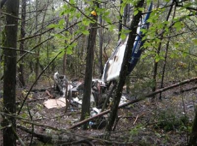
The airplane was located in a heavily wooded area 5 miles south of Mountain Home, Arkansas. The accident site consisted of the airplane main wreckage and a debris field that covered approximately 3,850 feet along a line beginning at the main wreckage and extending north on about a 001 degree magnetic heading. The airplane main wreckage consisted of the airplane’s cabin area and fuselage, the right wing, landing gear and engine. Also in the immediate vicinity of the main wreckage was the propeller hub with one of the three propeller blades. The other two propeller blades were also nearby. The main wreckage was lodged within several trees.
The airplane’s fuselage was oriented on a 262 degree heading. The cowling and cabin area, to include the instrument panel, glareshield and seats were broken open, charred and consumed by fire. The inboard portion of the right wing was charred and consumed by fire. The right aileron was bent forward and charred. An examination of the flight control system showed continuity from the control yokes to the control surfaces.
The engine was broken out, but intact and found resting on its left side. Most of the components were broken out. The propeller hub was broken at the flange mounting bolts. The hub and spinner were crushed and broken aft and inward. One propeller blade remained with the hub. It was curled forward and showed torsional bending, chordwise scratches and leading edge nicks and gouges. The other two propeller blades were located just forward of the engine. They were broken out from the hub. Both blades also showed torsional bending, chordwise scratches and leading edge nicks and gouges.
Airplane components extended to the north from the main wreckage. About 300 feet north of the main wreckage was the center section of the horizontal stabilizers and elevator. The section had been broken out with the most aft part of the fuselage. Both outboard sections of the horizontal stabilizers and elevators were bent downward and broken aft.
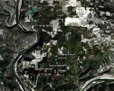
About 1,350 feet north of the main wreckage was the outboard portion of the right horizontal stabilizer. About 1,900 feet north of the main wreckage was the outboard portion of the left elevator.
About 2,300 feet north of the main wreckage and resting within tree branches was the vertical stabilizer. It was broken aft at the base. The rudder was broken out. About 2,350 feet north of the main wreckage was the top third of the rudder.
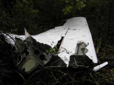
About 2,850 feet north of the main wreckage was the left wing. It was bent upward, twisted and broken aft at the root. The spars were broken upward and twisted aft. The left elevator was broken out. Aileron control cables showed unraveling and cup-cone breakages of the individual strands indicative of an overload failure.
At the farthest extent of the debris, 3,850 feet north of the main wreckage was the outboard half of the left aileron.
Results of toxicology testing of samples taken from the 32-year old pilot were negative for all tests conducted. Results of toxicology testing of samples taken from the 62-year old pilot showed volatile concentrations of Ethanol in muscle tissue at the level of 21 mg/dl, mg/hg. The Ethanol reported was from postmortem formation and not from ingestion.
(NTSB Photos main wreckage, left wing, map of wreckage distribution)
 ANN's Daily Aero-Linx (04.15.24)

