ForeFlight Mobile HD Rolls Out Version 4 | Aero-News Network
Aero-News Network
RSS icon RSS feed
podcast icon MP3 podcast
Subscribe Aero-News e-mail Newsletter Subscribe

Airborne Unlimited -- Most Recent Daily Episodes

Episode Date

Airborne-Monday

Airborne-Tuesday

Airborne-Wednesday Airborne-Thursday

Airborne-Friday

Airborne On YouTube

Airborne-Unlimited-04.01.24

Airborne-Unlimited-04.09.24

Airborne-Unlimited-04.10.24 Airborne-Unlimited-04.11.24

Airborne-Unlimited-04.12.24

Join Us At 0900ET, Friday, 4/10, for the LIVE Morning Brief.
Watch It LIVE at
www.airborne-live.net

Tue, May 03, 2011

ForeFlight Mobile HD Rolls Out Version 4

Available Now In The iTunes App Store

ForeFlight Mobile HD 4 is available for download as of Monday in iTunes App Store. Tyson Weihs, co-founder and principal developer for ForeFlight, tells ANN that this release takes ForeFlight forward in several significant ways, and lays the groundwork for additional features to come in 2011.

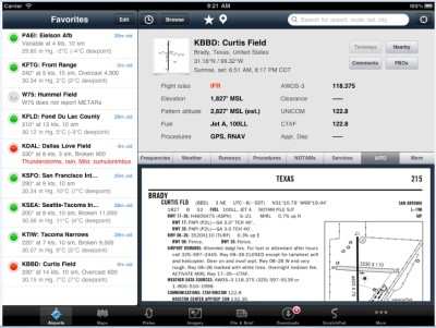
Now appearing on an airports page is a new segment titled “A/FD”. Click that and you’ll see the relevant page for that airport from the FAA’s A/FD. If the airport is big enough to have warranted multiple pages in the book, simply swipe left or right to get to the next page.

Weihs says the new navlog design is "sexy, sexy, sexy. Pilots have written in frequently asking “how hard is it to include ETE and ETA!”. Well, ETE and ETA are not hard to compute. However, taking the route and active leg into account and, more importantly, displaying that information in ForeFlight style took a bit of extra chiseling," he writes on the ForeFlight blog. Now available from the Maps page is a new, wider navlog that shows important metrics like summary trip information, leg times and distances remaining, and ETA. Current leg is shown in black, previous legs are faded, and a leg or direct route to a waypoint can be selected by tapping the new arrow button shown on each leg.

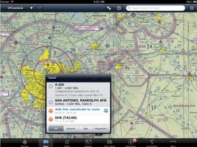
Tap on any of the blocks in the dashboard and select the instrument to be displayed. Options include fifteen different instrument types, including ETE to waypoint and destination, ETA to waypoint and destination, cross-track error, bearing to next waypoint or destination, Zulu time, GPS Accuracy, and more. Tap within an airspace boundary or special use airspace like a MOA, warning, alert, or prohibited area and all the required details are displayed. For airport details, tap on the airport and a popover is displayed with the airport information and a button to hop to that airport’s details.

The new Plates tab on the iPad makes it simple for both VFR and IFR pilots to organize sets of plates and airport diagrams for trips or practice sessions.  Easily add new plates from the Plates tab or when viewing a plate from airports. Create multiple binders to store trips and easily toggle between them.

Flying in the backcountry, Alaska, Africa, Gulf of Mexico, or even to the local practice area often means flying to places that aren’t specifically marked on a sectional or enroute chart. With the new personal waypoints feature, a large number of waypoints can be imported from a text file, or use the map to add a waypoint for any location. That personal waypoint can be named and included in a route search.

Weihs says the pace of adoption has quickened - at all levels, both by individuals and corporate/business operations - and pilots are looking for an app that fits most of their needs, most of the time. "We think ForeFlight fits that requirement for the large majority of pilots very well," he says. "We now support five Fortune 50 flight departments, with more climbing aboard every day."

FMI: www.foreflight.com

Advertisement

More News

ANN's Daily Aero-Linx (04.13.24)

Aero Linx: Florida Antique Biplane Association "Biplanes.....outrageous fun since 1903." That quote really defines what the Florida Antique Biplane Association (FABA) is all about.>[...]

ANN's Daily Aero-Term (04.13.24): Beyond Visual Line Of Sight (BVLOS)

Beyond Visual Line Of Sight (BVLOS) The operation of a UAS beyond the visual capability of the flight crew members (i.e., remote pilot in command [RPIC], the person manipulating th>[...]

Airborne 04.09.24: SnF24!, Piper-DeltaHawk!, Fisher Update, Junkers

Also: ForeFlight Upgrades, Cicare USA, Vittorazi Engines, EarthX We have a number of late-breaking news highlights from the 2024 Innovation Preview... which was PACKED with real ne>[...]

Aero-News: Quote of the Day (04.14.24)

“For Montaer Aircraft it is a very prudent move to incorporate such reliable institution as Ocala Aviation, with the background of decades in training experience and aviation>[...]

ANN's Daily Aero-Term (04.14.24): Maximum Authorized Altitude

Maximum Authorized Altitude A published altitude representing the maximum usable altitude or flight level for an airspace structure or route segment. It is the highest altitude on >[...]

blog comments powered by Disqus


Advertisement

Advertisement

Podcasts

Advertisement

© 2007 - 2024 Web Development & Design by Pauli Systems, LC