Netherlands Loses Satellite In Russian Rocket Explosion | Aero-News Network
Aero-News Network
RSS icon RSS feed
podcast icon MP3 podcast
Subscribe Aero-News e-mail Newsletter Subscribe

Airborne Unlimited -- Most Recent Daily Episodes

Episode Date

Airborne-Monday

Airborne-Tuesday

Airborne-Wednesday Airborne-Thursday

Airborne-Friday

Airborne On YouTube

Airborne-Unlimited-04.01.24

Airborne-Unlimited-04.16.24

Airborne-FlightTraining-04.17.24 Airborne-Unlimited-04.11.24

Airborne-Unlimited-04.12.24

Join Us At 0900ET, Friday, 4/10, for the LIVE Morning Brief.
Watch It LIVE at
www.airborne-live.net

Wed, Jan 31, 2007

Netherlands Loses Satellite In Russian Rocket Explosion

Platform Launch Attempt From Equatorial Pacific Unsuccessful

Commercial rocket company Sea Launch lost both a rocket and the commercial communications satellite destined to serve Netherlands-based SES New Skies in an unsuccessful launch attempt Tuesday as a Zenit-3SL rocket exploded on the mobile floating launch platform stationed in the equatorial Pacific.

Sea Launch spokesperson Paula Korn told the Associated Press, "There was an explosion as we were lifting off."

Sea Launch, based in Long Beach, CA, is a consortium owned by Boeing, Russia's RSC-Energia, Norway's Kvaerner ASA and Ukraine's SDO Yuzhnoye/PO Yuzhmash.

The NSS-8 satellite, a Boeing product, was to provide audio, video, data and internet service for countries in Europe, Africa, the Middle East, and southern Asia according to Sea Launch. It was to replace New Skies' NSS-703 which must now remain in orbit until at least 2009. NSS-8 would have been the sixth New Skies satellite in orbit; the company has another currently under construction.

"The NSS-8 launch failure is thus not expected to have an impact on existing customers or revenues," SES New Skies said.

The platform Sea Launch uses to launch its rockets, called Odyssey, is a converted oil drilling rig. The company says its cleared of all personnel before a launch, which is then directed from a ship, Sea Launch Commander, stationed a few miles away.

Sea Launch uses a platform stationed near the equator for its launches to take advantage of the physics of earth's rotation. The higher speeds of rotation near the equator allows for heavier payloads.

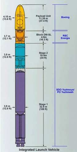
The Zenit-3SL rocket is a kerosene and liquid oxygen-fueled three-stage vehicle. It's nearly 200 feet tall and about 14 feet in diameter.

This adds to a string of notable (and expensive) failures in Russia's efforts to become involved in the growing commercial spaceflight industry. Last year, two Russian-built rockets made unsuccessful launch attempts; one, a Dnepr rocket carrying 18 satellites, crashed after liftoff from Baikonur spreading toxic chemicals across a wide swath of Kazakh Steppe. The ensuing environmental disaster prompted the Kazakh government to ban all future Dnepr rocket operations at Baikonur.

FMI: www.boeing.com/special/sea-launch/index.html

Advertisement

More News

ANN's Daily Aero-Linx (04.15.24)

Aero Linx: International Flying Farmers IFF is a not-for-profit organization started in 1944 by farmers who were also private pilots. We have members all across the United States a>[...]

Classic Aero-TV: 'No Other Options' -- The Israeli Air Force's Danny Shapira

From 2017 (YouTube Version): Remembrances Of An Israeli Air Force Test Pilot Early in 2016, ANN contributor Maxine Scheer traveled to Israel, where she had the opportunity to sit d>[...]

Aero-News: Quote of the Day (04.15.24)

"We renegotiated what our debt restructuring is on a lot of our debts, mostly with the family. Those debts are going to be converted into equity..." Source: Excerpts from a short v>[...]

Airborne 04.16.24: RV Update, Affordable Flying Expo, Diamond Lil

Also: B-29 Superfortress Reunion, FAA Wants Controllers, Spirit Airlines Pulls Back, Gogo Galileo Van's Aircraft posted a short video recapping the goings-on around their reorganiz>[...]

ANN's Daily Aero-Term (04.16.24): Chart Supplement US

Chart Supplement US A flight information publication designed for use with appropriate IFR or VFR charts which contains data on all airports, seaplane bases, and heliports open to >[...]

blog comments powered by Disqus


Advertisement

Advertisement

Podcasts

Advertisement

© 2007 - 2024 Web Development & Design by Pauli Systems, LC