Talks Instead About NextGen NAS Weather
Editor's Note: Below is the unedited text
of a speech entitled "You Need To Know What You Don't Know" that
FAA Administrator Marion Blakey gave Tuesday before the Aero Club
in Washington, DC.

In her speech, Blakey acknowledges attendees were likely
hoping to hear details about the FAA's future funding plans... but
instead, the speech focuses primarily on weather, and how the FAA's
much-ballyhooed, but still undefined, NextGen National Airspace
System (NAS) will handle forecasting duties for pilots.
That's important information, certainly. In light of ANN's report Monday, however,
on alleged draft documents of a proposed FAA Reauthorization Bill
that would institute a harsh User Fee program across all segments
of general aviation -- while apparently giving
airlines a break in such fees -- pilots might appreciate a bit more
information from the FAA on the topic of user fees from the
Administrator... especially after telling attendees at AOPA Expo
earlier this month (above) that she was against "broad" user fees
for GA.
The draft documents would appear to indicate the broadest of
user fees are still very much on the FAA's radar screen.
To date, Aero-News has received no public comment from the
FAA about our story. Comments we've received since then from those
familiar with the issue, however, seem to confirm the draft
proposal is for real... and may very well be the precursor to the
FAA funding proposal to be submitted early next year.
Aero-News respectfully requests the FAA give pilots more
information about this user fee proposal... an issue in which all
pilots truly 'need to know what they don't know.'
*****
 Good afternoon, and
thank you, Debbie [McElroy]. It’s a special pleasure to be
here. It’s a very special pleasure to pay tribute to one of
the greatest pilots of our time — of all time. The Engen
Trophy is certainly well deserved.
Good afternoon, and
thank you, Debbie [McElroy]. It’s a special pleasure to be
here. It’s a very special pleasure to pay tribute to one of
the greatest pilots of our time — of all time. The Engen
Trophy is certainly well deserved.
Normally, when you don’t know what to talk about with
folks you talk about the weather. Well, today’s a little bit
different. I know exactly what I want to talk about and that is the
weather. Now I look around the room, and I see a few of you saying,
“Oh, man, I was hoping she was going to give us some insight
on the Trust Fund and Reauthorization or maybe Age 60.” Nope.
And those of you with an allergy to acronyms better head for the
exits. What I’m going to focus on today is what I think is
one of the top two or three operational and research challenges we
face but often is sort of the Rodney Dangerfield of aviation and
doesn’t get enough attention or respect.
For those of you who are unaware, today is the anniversary of
the start of Admiral Byrd’s flight over the South Pole. The
year was 1929.
November 28 is also the anniversary of another fairly
significant transportation event: Back in 1520, Magellan reached
the Pacific Ocean from the Atlantic — the hard way. Using the
Straits of Magellan was the best route considering the information
he had. And, no doubt, the explorer must have thought he was at the
bottom of the world. A few centuries later, then-Commander Byrd had
a different view — figuratively and literally — about
the oceans and the actual bottom of the world.
Generally speaking, the conditions were roughly the same for
both men. The geography was the same. One explorer had better
information. Both brave. Both determined. Byrd’s flight
wasn’t what I’d call easy by any stretch, but it shows
how a little information can go an awfully long way.
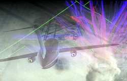
No doubt the pilots in this room feel precisely the same about
weather. In fact, weather is a contributing or causal factor in 87
percent of all GA accidents. Moreover, just about three out of four
airline delays over the last five years are attributed to Mother
Nature.
 Now, I’d be
remiss not to mention the success we had with Thanksgiving weekend
traffic. We had good weather, but as always, there was quite a
spike in the amount of traffic. Sunday was up 16 percent. And when
it was all done, I can say with certainty that everyone ran a
ship-shape operation. Hats off. When we needed a clutch
performance, we got it.
Now, I’d be
remiss not to mention the success we had with Thanksgiving weekend
traffic. We had good weather, but as always, there was quite a
spike in the amount of traffic. Sunday was up 16 percent. And when
it was all done, I can say with certainty that everyone ran a
ship-shape operation. Hats off. When we needed a clutch
performance, we got it.
You may be surprised to know that playing a part in this was our
airspace flow program which we put in place to handle difficult
enroute weather patterns. Yeah, I know it was good weather, but
over the weekend, we used it for the first time to handle high
volume at high altitudes on the East Coast. The corridors from D.C.
to New York and Cleveland to New York. Let me tell you, it
worked.
The airspace flow program itself has been in place since June,
and the early results are good. Preliminary data indicate delays
during severe weather events have been reduced approximately 21
percent for flights destined to airports in the eastern U.S. Data
also indicate a decrease in the number of cancelled flights, about
eight percent on severe weather days. We expect that that will
translate to a savings of $900 million over the next 10 years.
This program is designed to address delays associated with
airspace constraints. There was a time that ground delay programs
were implemented for multiple airports in response to severe
weather. Working with industry, now for the first time we’re
able to provide options to ground delays with predictable results.
When the customer gets an option whether to file through or file
around, it’s a good sign for both of us.
As the saying goes, you can’t control the weather but you
can control how you deal with it. Just like Admiral Byrd, just like
Magellan, step one is to be aware of it, to have the best
information out there.
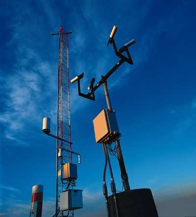
So where are we? There’s some very exciting work being
done with measurements in the troposphere, the lower part of the
atmosphere. Much of our forecasting since the early 1920’s
has involved the deployment of weather balloons. Now, there are 69
spread across the country with information coming every 12 hours,
capturing atmosphere data.
Today, we’re also able to capture atmospheric measurements
from several hundred commercial aircraft through a program called
Meteorological Data Collection and Reporting System. You may know
it by its abbreviation: MDCRS. In fact we get over a hundred
thousand observations per day of winds aloft, temperature,
pressure, and turbulence from this program. Participating airlines
collect the data for us at no cost and share the cost with the
government to get the data to the ground. ARINC then sends it on to
FAA and NWS to improve the forecasts and our automated air traffic
support tools.

On the downside, this program doesn’t give us humidity,
but there’s a company called AirDat that’s in the early
stages of what one day might plug that hole and bring aviation a
little more quickly into the 21st century. With a program called
TAMDAR, for Troposphere Airborne Meteorological Data Reporting;
they’re placing a multi-function atmospheric sensor aboard
aircraft and they’re using a dedicated two-way satellite link
through Iridium to get the objective information relayed to
meteorologists. The sensor is smaller than a lunch box and weighs
less than two pounds. The transmission takes about 8 to 12
seconds.
As you know, data collection below 20,000 feet had been lean. By
outfitting smaller commuter aircraft, we’re getting input
from an entire fleet, quite a jump from balloons. The cost-benefit
piece of this equation has yet to be fleshed out, but a good idea
is a good idea.
And sometimes, the simple ideas are the best ideas. The sensors
record humidity, pressure, temperature, winds aloft, icing,
turbulence, true airspeed and location, time, and altitude from a
built-in GPS. It’s been operational in the central United
States for about 18 months. Like I said, the days of relying solely
on weather balloons and subjective pilot reports are coming to a
close. They aren’t unimportant. But moving toward data
collection turbocharged with satellite relays is a step up,
don’t you think?
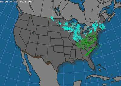
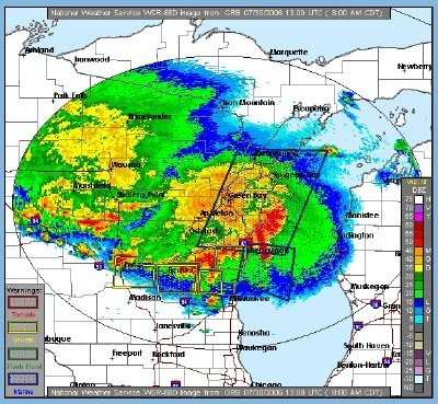
Let me turn to an FAA project: the Collaborative Convective
Forecast Product. The CCFP has been around for a few years at http://aviationweather.gov
. No www; just aviationweather.gov. During the convective weather
season, which stretches from March through October, a team of
government meteorologists, our center weather service unit staff
and the airlines put out a forecast every two hours, round the
clock, 24/7. This is information that goes to everyone, available
to anyone who needs it. If you’re looking for news, here it
is. We’re expanding. Right now, the forecast looks out six
hours. We’re looking at going to eight. We’re
increasing the strength, the reliability, of the forecast with
better software.
Working collaboratively is definitely the way to go. At the
heart of collaboration is traffic flow management. On one hand, you
have air traffic control which is all about controllers and
separation. Air traffic control begins when an aircraft pushes back
from the gate, and it ends when it pulls back in. Traffic flow
management, on the other hand, is more the science of aviation.
It’s about understanding how traffic flows across the system,
how the system moves and adapts nationwide.
The Command Center in Herndon is the FAA’s brain trust for
traffic flow management. If you remember back to the day where the
system got bogged down because the airlines were holding everything
close to the vest and blaming ATC for all the delays, you know that
things are different. Now, every morning at 7:15 and every two
hours throughout the day there’s a telecon about the status
of the national airspace system. Weather is one of the main topics
discussed. The system is orchestrated much more smoothly as a
result. And we collaborate with all our customers, the airlines,
and GA.
This is all part of collaborative decision making in which the
government and users make good decisions together, instead of
decisions made against each other in vacuum. Collaborative decision
making is a lot like the World Wide Web. The more information you
get in response to your search, the better it gets. Richer and
richer information, allowing everybody to make better decisions for
the day.
Now we’re not stopping there. Our laboratories are
producing new products as well. For example, after several years of
development and testing, we are scheduled to roll out an
operational in-flight icing product that GA has been especially
eager to see. For several years now, you told us you wanted the
ability to use the Current Icing Product Severity as an operational
tool. Well, in two months or less, in time for much of this icing
season, CIP Severity will be fully operational. This product
combines observations from satellite, radar, surface, lightning
networks, and pilot weather reports with model output to provide a
detailed, hourly, three dimensional diagnosis of in-flight icing
conditions and potential for super-cooled liquid droplets.
Â
In one sentence, our goal is to enable flight deck weather
information technologies that allow pilots to engage in shared
situational awareness.
I’ve just run though a laundry list that shows we’re
taking weather seriously today. But it’s a fair question for
one of you to ask, “That’s good, but what about
tomorrow?”
We’re hard at that, too. The next generation air
transportation system — NextGen — is going to answer
the mail.
The challenge of weather is arguably the biggest and most
complex we face. It’s the wild card that’s always going
to be out there. The fact of the matter is we just don’t
forecast very well. That’s not an indictment of the
meteorologist. It’s an observation about the state of the
science that enables us to peek into the future. It’s one
thing when you’re planning the family picnic for next
Saturday. But when you’re trying to vector thousands of
aircraft from point A to point B — and I’m not just
talking about into O’Hare or Kennedy, but at the smaller
airports as well — that type of choreography requires an
accurate picture several days out.
We can’t do it. And even with all of these steps,
we’ll never completely do away with constraints on the
system. Let’s face it: weather’s always going to be
there to deal with.
I’m not bursting your balloon — weather or otherwise
— but what I am pointing to is that we need to make a
cultural shift in our approach to the weather. First, there’s
got to be a shift in how forecasting itself is perceived. As the
forecasts get better, people have to take more stock in them. That
comes from being able to rely on the information you’re
getting. Everybody jokes about the weatherman, but you and I know
that comes from the reflex that he’s going to get it wrong.
That’s got to change, and I think it will as products and
forecasts become more reliable. In addition, I opened my comments
with the mention of how good information needs to be available. And
that’s true. We need to change how the national airspace
system responds to and utilizes the weather information
that’s produced.
The NextGen vision is to assure that everybody in the system has
the same set of information. When there’s a weather-related
event, everybody would have knowledge of it, and they’d be
aware at about the same time. The challenge for us — and you
— is to change the NAS from being a system that’s
reactive into one that’s proactive. Instead of waiting until
after something’s happened and using an operational tool such
as a ground delay program, we want to make smarter risk-based
decisions before the event has occurred. We want to take that
weather information and use it to formulate actions that are less
painful, less dramatic, and further out. The further out in time we
can make strategic operational weather decisions, the less impact
NextGen will endure.
We need a network-enabled common weather picture of now as well
as one, two, and six hours from now. Everybody in the system right
now is making decisions based on different pictures and different
interpretations of those pictures. A network gives everyone the
same look.
To get there, you can’t have only one weather provider for
observations and forecasts. We want to have many sources, as many
as we can get. As I said, one of the real science challenges is how
do you then fuse all that data in to a single picture and
continuously distribute it to everybody. Our concept for that is
called NNEW — NextGen Network Enabled Weather.
There’s good news here. We’re already working with
DoD, Commerce, and NASA to leverage their investments in this
capability. This will help us launch sooner: The delivery for an
initial capability is scheduled for 2012.
When all this information becomes available, and it gets to you
in time for you to use it, well, that’s the kind of leap into
the next century of aviation that we need to make. Secretary Mary
Peters calls it 21st century solutions to 21st century problems,
and I think she’s right. In 1929, the very same year of
Admiral Byrd’s famous flight, the government’s
Interdepartmental Committee on Civil Airways was urging the
Aeronautics Branch to strengthen its weather-reporting services,
particularly in terms of collecting weather data. This issue
isn’t new, but our approach sure is.
Because we are working together to organize our weather efforts
from research and development to the systems we use every day to
make sure we’re addressing the right weather problems and
coming up with the right solution. It’s true that
there’s probably not going to be a next generation air
traffic control system that’s immune to the headaches of
convective weather. But a little information can go a long way. And
when you get the right information to the right people at the right
time, advancements are sure to follow, without having to use the
Straits of Magellan to do it.
 ANN's Daily Aero-Term (04.14.24): Maximum Authorized Altitude

