Fri, May 16, 2003
Airdrop Behavior of Cargo Pallets Testing
Thales Navigation, a leading provider of GPS solutions for
positioning, navigation and communications applications, is playing
an important role in the U.S. military's efforts to assess and
optimize parachute-rigging designs for the airdropping of large
cargo pallets.
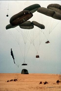 In a
series of tests conducted by the U.S. Army Operational Test
Command, Airborne and Special Operations Test Directorate in Fort
Bragg (NC), Thales Navigation's G12 GPS receiver was used in
concert with an inertial measurement unit (IMU) to record and
analyze parachute payload behavior - including continuous
positioning, velocity and attitude -- during and after exit from an
aircraft. The instrumentation package, called the Airborne Position
Location Instrumentation (APLS) system, was developed for the Army
Operational Test Command by SRI International, an independent
research organization in Menlo Park (CA).
In a
series of tests conducted by the U.S. Army Operational Test
Command, Airborne and Special Operations Test Directorate in Fort
Bragg (NC), Thales Navigation's G12 GPS receiver was used in
concert with an inertial measurement unit (IMU) to record and
analyze parachute payload behavior - including continuous
positioning, velocity and attitude -- during and after exit from an
aircraft. The instrumentation package, called the Airborne Position
Location Instrumentation (APLS) system, was developed for the Army
Operational Test Command by SRI International, an independent
research organization in Menlo Park (CA).
Operational requirements for the GPS receiver included a
relatively high differential update rate of at least 10 Hz. The
Thales unit offered 20 Hz. In addition, the receiver needed to
supply analyzable raw data, which the G12 was also able to
provide.
Reacquiring satellite signals
The G12 performed its role of providing time reference
information and calibration of the IMU strongly in other ways. As
the pallet was released from the aircraft in testing, the receiver
would temporarily lose contact with the GPS satellites for a few
seconds as an external antenna on the receiver reacquired the
satellite signal. During that brief period, an inertial measurement
unit (IMU) collected data as a backup. The G-12 performed well in
signal reacquisition tests.
The testing also called for rugged, relatively shockproof
equipment. The receiver and the IMU were both housed in a 10-pound
aluminum-encased package along with a small computer, CPU card and
an external battery. Pallets carrying some 30,000 pounds of cargo
were dropped from altitudes of 1,500 feet from aircraft flying at
120 miles per hour. Pallet loads often undergo forces of 2 to 4 g's
upon extraction from the aircraft and up to 100 g's on landing -
stresses that call for unusually rugged measurement equipment. The
combination of good update rates and reliable performance provided
meaningful data and positioning readings.
More News
Aero Linx: International Flying Farmers IFF is a not-for-profit organization started in 1944 by farmers who were also private pilots. We have members all across the United States a>[...]
From 2017 (YouTube Version): Remembrances Of An Israeli Air Force Test Pilot Early in 2016, ANN contributor Maxine Scheer traveled to Israel, where she had the opportunity to sit d>[...]
"We renegotiated what our debt restructuring is on a lot of our debts, mostly with the family. Those debts are going to be converted into equity..." Source: Excerpts from a short v>[...]
Also: B-29 Superfortress Reunion, FAA Wants Controllers, Spirit Airlines Pulls Back, Gogo Galileo Van's Aircraft posted a short video recapping the goings-on around their reorganiz>[...]
Chart Supplement US A flight information publication designed for use with appropriate IFR or VFR charts which contains data on all airports, seaplane bases, and heliports open to >[...]
 ANN's Daily Aero-Linx (04.15.24)

