Flights Document Midwest States' Critical Infrastructure
Concerns
 Civil Air Patrol aircraft and personnel from seven Midwest
states have returned home after providing nearly 360 hours of
flight time supporting disaster relief efforts in North Dakota,
South Dakota and Minnesota.
Civil Air Patrol aircraft and personnel from seven Midwest
states have returned home after providing nearly 360 hours of
flight time supporting disaster relief efforts in North Dakota,
South Dakota and Minnesota.
"Our mission is complete," said Illinois Wing Maj. Eric Templeton,
who directed CAP's ARCHER flights over the Red River Valley as well
as other parts of North Dakota from the organization's flood
response mission base at Fargo's Hector International Airport. "I'd
like to express my personal thanks to everyone who directly and
indirectly supported our activities, especially those who covered
for us back home."
Acting as an auxiliary of the U.S. Air Force, CAP sent aircrews
from Illinois, Minnesota, Missouri, North Dakota, Ohio, South
Dakota and Wisconsin to the Fargo mission base. The aircrews flew
160 still photography and ARCHER flights, delivering 1,100 images
and 1,270 gigabytes of ARCHER information to the Federal Emergency
Management Agency, the North Dakota Emergency Operations Center,
U.S. Geological Service, National Geospatial-Intelligence Agency
and the Minnesota Department of Transportation.
The Airborne Real-time Cueing Hyperspectral Enhanced
Reconnaissance, or ARCHER, is flown aboard CAP's Australian-built
Gippsland GA-8 aircraft. Developed a few years ago specifically for
Civil Air Patrol to aid in search and rescue, homeland security and
disaster relief, ARCHER is one of the most sophisticated
non-classified airborne imaging systems in the world. It provides
both high-resolution and hyperspectral imaging capabilities through
two advanced sensors on board each CAP Airvan.
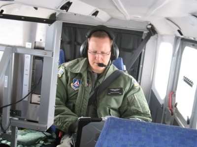
Maj. Doug Ployhar operates Civil Air
Patrol's ARCHER system.
Photo Credit Lt. Col. Paul
Adams
Federal and state emergency management
officials used ARCHER images taken in North Dakota and Minnesota to
determine the extent of the flood inundation along the Red River as
well as other rivers and tributaries as they crested and to help
analyze the integrity of several earthen dams. The images also
helped officials improve the snow melt models used to predict water
levels for the river and its tributaries.
"This provided more than just situational awareness," said Capt.
Nash Pherson, a Minnesota Wing volunteer who helped coordinate the
ARCHER flights. "We were able to rapidly provide high-resolution
imagery that could be pulled into the mapping systems used by
emergency response decision-makers."
More than 30 CAP members utilizing four GA-8 Airvans and 12 other
aircraft supported ARCHER. "Each agency was very happy with the
speed and quality of the data it received from ARCHER," said
Templeton, adding, "North Dakota officials are interested in some
longer-term tasking activities to support other needs of the
state."
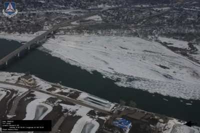
Missouri River In Bismark Photo Courtesy
CAP
While ARCHER was out collecting data,
other aircrews often used the 12 support planes at the Fargo
mission base "to provide ice jam patrols all over the state as well
as still images of rivers and tributaries," said Lt. Col. Bill Kay,
the incident commander for North Dakota Wing. "Our crews worked the
Missouri, Knife, Heart and Cannonball rivers in central North
Dakota, while others flew the James, Sheyenne, North Red, Forest
and Park rivers on the eastern side of the state from the North
Dakota-South Dakota border to Canada. We are still doing that even
today, albeit at a lesser degree."
Similar activities were repeated in South Dakota, on the rivers and
tributaries in the Mount Rushmore State. Capt. John Seten, South
Dakota Wing's incident commander, said aircrews provided
overflights of flooded areas of the state and took geographically
tagged aerial photographs of ice jams and flood damage for the
state's Office of Emergency Management.
 ANN's Daily Aero-Linx (04.16.24)

