Mon, Feb 23, 2009
Integrated with High Performance Radar Altimeters
FreeFlight Systems and Sandel Avionics are collaborating on the
integration of Sandel's ST3400H Helicopter Terrain Awareness and
Warning System (HTAWS) with FreeFlight Systems' high performance
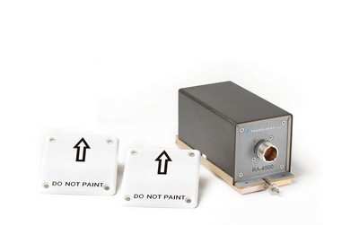
RA-4000 series of radar altimeters, including the new RA-4500 with
the ARINC 429 interface.
Sandel's new ST3400H is a self contained TSO-C194 certified
HTAWS using proprietary 3-ATI high brightness/high resolution
display technology with LED backlight. The ST3400H, in combination
with one of FreeFlight Systems' TSO-C87 certified radar altimeters
(RA-4000 or RA-4500), will allow HTAWS alerting capability while
providing the pilot with a continuous display of ultra high
resolution terrain, obstacles, traffic, and height above ground.
Owners of pre-existing radar altimeter indicators are now able to
enhance aircraft safety by replacing their display with this new
ST3400H HTAWS - Radar Altimeter System.
"Our collaboration with Free Flight Systems will provide
significant safety benefits to the helicopter community," comments
Gerry Block, president and CEO, Sandel Avionics. "Our joint purpose
is to ensure that our products work together as a package that will
allow the highest performance, fastest installation, and lowest
installed cost upgrade path for those desiring the safety
improvement of HTAWS. When installed with the FreeFlight Systems
RA-4000 or RA-4500, the ST3400H will provide, what are commonly
known as 'Class-A' alerting features such as audible altitude
callouts, in addition to basic TAWS alerting."
"When FreeFlight Systems and Sandel decided to collaborate on
integrating our RA-4000 and RA-4500 Radar Altimeters with their new
ST3400H HTAWS, enhanced pilot safety and operational success were
at the forefront of our thinking," stated Tim Taylor, president and
CEO, FreeFlight Systems. "On the practical side, with space at a
premium, our collective design focused on size and weight and ease
of operations. In this manner, the installation is quick, and
training requirements are minimal so the pilot can take advantage
of these critical safety features immediately."
An option for on demand Night Vision Imaging System (NVIS)
compatibility is also available. Delivery of the new system is
planned for the third quarter, 2009.
More News
Aero Linx: Florida Antique Biplane Association "Biplanes.....outrageous fun since 1903." That quote really defines what the Florida Antique Biplane Association (FABA) is all about.>[...]
Beyond Visual Line Of Sight (BVLOS) The operation of a UAS beyond the visual capability of the flight crew members (i.e., remote pilot in command [RPIC], the person manipulating th>[...]
Also: ForeFlight Upgrades, Cicare USA, Vittorazi Engines, EarthX We have a number of late-breaking news highlights from the 2024 Innovation Preview... which was PACKED with real ne>[...]
“For Montaer Aircraft it is a very prudent move to incorporate such reliable institution as Ocala Aviation, with the background of decades in training experience and aviation>[...]
Maximum Authorized Altitude A published altitude representing the maximum usable altitude or flight level for an airspace structure or route segment. It is the highest altitude on >[...]
 ANN's Daily Aero-Linx (04.13.24)

