Airbus And ZF To Develop Highly Precise End-To-End Autonomous Driving Solution | Aero-News Network
Aero-News Network
RSS icon RSS feed
podcast icon MP3 podcast
Subscribe Aero-News e-mail Newsletter Subscribe

Airborne Unlimited -- Most Recent Daily Episodes

Episode Date

Airborne-Monday

Airborne-Tuesday

Airborne-Wednesday Airborne-Thursday

Airborne-Friday

Airborne On YouTube

Airborne-Unlimited-04.01.24

Airborne-Unlimited-04.16.24

Airborne-FlightTraining-04.17.24 Airborne-Unlimited-04.11.24

Airborne-Unlimited-04.12.24

Join Us At 0900ET, Friday, 4/10, for the LIVE Morning Brief.
Watch It LIVE at
www.airborne-live.net

Sat, Apr 20, 2019

Airbus And ZF To Develop Highly Precise End-To-End Autonomous Driving Solution

Will Utilize Radar Satellite Imagery Provided By Airbus

Airbus Defence and Space and ZF Friedrichshafen AG, a system provider for mobility, are collaborating to enrich and complement ZF on-board system to enhance autonomous driving by using Airbus satellite derived information.

Under this collaboration, Airbus and ZF are combining their capabilities and expertise to offer a reliable end-to-end solution for self-driving and self-positioning vehicles. To answer the extreme level of accuracy required, Airbus provides its unique high precise Ground Control Points (GCPs), calculated using radar satellite imagery, to support the fusion of ZF sensor data such as Lidar and Radar. In addition, the GCPs serve as independent data source to improve and validate the accuracy of mobile mapping data.

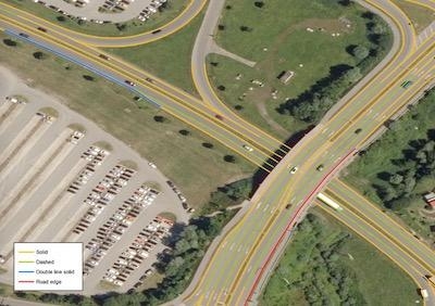
Furthermore Airbus investigates generation of High Definition maps (HD maps) based on aerial and space borne approach, to complement ZF semantic cards. HD Maps are key to ensure the guiding route, as they build an important link between mobile mapping data and global positioning systems. They contain more information than just the road itself, as lanes, the radius of curves, lane widths, street signs, bridges, and buildings, as well as their distance from one another. Both remote sensed information GCPs and HD maps will be integrated as foundation layers into the “ZF AD Environment” – an enhanced HD maps solution ZF will present soon – where all needed information for autonomous driving will be implemented in a cloud based system.

Autonomous driving is a new, enthusing and challenging market for Airbus, as the highest level of autonomy requires the highest maps precision.

(Image provided with Airbus news release)

FMI: www.airbus.com

Advertisement

More News

ANN's Daily Aero-Linx (04.16.24)

Aero Linx: International Business Aviation Council Ltd IBAC promotes the growth of business aviation, benefiting all sectors of the industry and all regions of the world. As a non->[...]

Aero-News: Quote of the Day (04.16.24)

"During the annual inspection of the B-24 “Diamond Lil” this off-season, we made the determination that 'Lil' needs some new feathers. Due to weathering, the cloth-cove>[...]

Airborne 04.10.24: SnF24!, A50 Heritage Reveal, HeliCycle!, Montaer MC-01

Also: Bushcat Woes, Hummingbird 300 SL 4-Seat Heli Kit, Carbon Cub UL The newest Junkers is a faithful recreation that mates a 7-cylinder Verner radial engine to the airframe offer>[...]

Airborne 04.12.24: SnF24!, G100UL Is Here, Holy Micro, Plane Tags

Also: Seaplane Pilots Association, Rotax 916’s First Year, Gene Conrad After a decade and a half of struggling with the FAA and other aero-politics, G100UL is in production a>[...]

Airborne-Flight Training 04.17.24: Feds Need Controllers, Spirit Delay, Redbird

Also: Martha King Scholarship, Montaer Grows, Textron Updates Pistons, FlySto The FAA is hiring thousands of air traffic controllers, but the window to apply will only be open for >[...]

blog comments powered by Disqus


Advertisement

Advertisement

Podcasts

Advertisement

© 2007 - 2024 Web Development & Design by Pauli Systems, LC