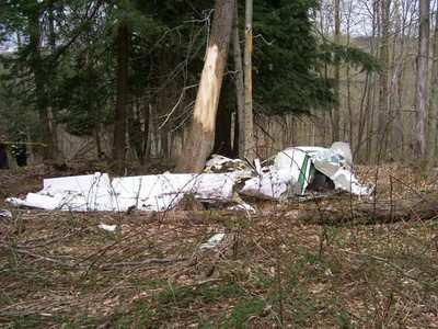
Wreckage Path Over 1/4 Mile Long
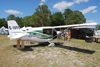
 The tragic and somewhat mysterious fate of the Canadian
Ecoflyer demonstrator, returning home from a Florida aviation event
appears to (still) leave a number of questions as to what happened
to the aircraft to bring it down.
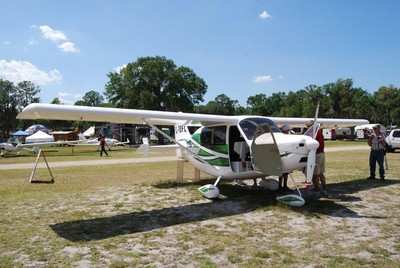
The tragic and somewhat mysterious fate of the Canadian
Ecoflyer demonstrator, returning home from a Florida aviation event
appears to (still) leave a number of questions as to what happened
to the aircraft to bring it down.
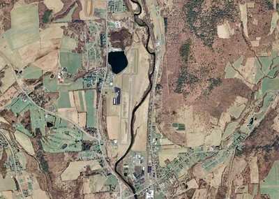
Explorer Aeronautique President Bernard LaFerriere, 56, of
Quebec, Canada, perished when his Ecoflyer G-IOFL went down in New
York, near the Lt. William Eaton Airport. Imagery from the heavily
wooded impact site show that the crash [State Police accident photo
below] was a devastating one, with no significant aspect of the
airframe escaping destruction.
LaFerriere was on his way back from the Lakeland Fly-In and had
stopped in Norwich, New York, enroute to Quebec's Trois-Rivieres
airport -- its home base. NY State Troopers report that the
aircraft departed the airport about 1630, local time Monday, and
that an alert was sent out when he was discovered to be overdue.
The wreckage was not located until Tuesday afternoon. LaFerriere
appears to have perished on impact.
Prior to departure from Norwich, airport staffers report that
LaFerriere refueled his aircraft and waited a considerable time on
the ground for winds to stabilize before departing.
The NTSB report notes that, "Personnel at OIC reported that the
pilot landed at the airport around 1400. He reported to them that
he had encountered "rough air and wind gusts like he had never seen
before." The personnel reported he was "very shook up" about the
encounter. The pilot fueled the airplane adding 10 gallons of fuel,
which "topped the tanks." He also called the Buffalo Flight Service
Station (FSS) and requested information regarding restricted
airspace along his route of flight into Canada. The pilot remained
at the airport for several hours and departed at about 1630.
Airport personnel watched the airplane depart and reported no
anomalies with the departure."
The NTSB reports add that, the wreckage was examined on April
29, 2009, and all major components were accounted for at the scene
with the exception of the right horizontal stabilizer.
The left wing was the first piece of wreckage found at the most
southern end of the wreckage path. It came to rest perpendicular to
the ground, with the inboard section of the wing at the base of the
tree. The outboard section of the wing was partially separated from
the inboard section, and remained attached by flight control
cables. The outboard section with the aileron attached was observed
suspended at the top of the tree.
The wreckage path continued about ¼ mile to the main
wreckage, through heavily wooded terrain, oriented on a heading of
300 degrees. Located along the wreckage path were the left wing
strut, an outboard section of left wing, and the right
elevator.
The left wing strut was located about 578 feet from the left
wing, to the right of centerline. The top end of the strut
contained the attachment hardware for the wing.
The complete right elevator was located 920 feet from the left
wing on the centerline of the wreckage path.
The main wreckage came to rest, at the base of a tree, oriented
on a heading of approximately 080 degrees magnetic. Trees
surrounding the airplane were virtually undisturbed and there was
no forward wreckage path. Propeller slash marks were noted in the
tree, at a height of approximately 7 feet. The bark of the tree was
removed from that height to the ground.
The right wing and wing strut were separated from the fuselage,
and was observed adjacent to the cockpit area of the fuselage, at
the base of the tree. The right flap remained attached to the wing
at all attachment points. The right wing strut was also located
adjacent to the wing.
The empennage section was separated from the fuselage area and
observed adjacent to it. The left horizontal stabilizer, with
elevator attached, remained attached to the empennage; however the
right horizontal stabilizer was separated and not located to
date.
The vertical stabilizer was attached to the empennage, and the
rudder was attached to the vertical stabilizer at its top
attachment point.
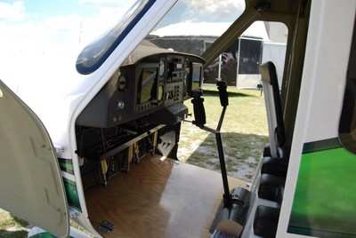
The engine was observed intact in the cockpit area of the main
wreckage. The propeller hub was separated from the engine and both
blades were fractured at about their mid-span.
The weather reported at Syracuse International Airport (SYR),
Syracuse, New York, at 1654, included winds from 340 degrees at 8
knots, 10 miles visibility, few clouds at 5,500 feet, scattered
clouds at 21,000 feet, temperature 29 degrees C, dew point 12
degrees and altimeter setting 30.14 inches mercury.
Personnel at OIC kept a log of weather observations taken hourly
from the Automated Weather Observing System (AWOS) on the field. At
1345 the surface winds were recorded as 220 degrees at 8 knots,
gusting to 18 knots. The winds remained relatively constant for the
next several hours, and at 1645 the winds were from 240 degrees at
8 knots, gusting to 20 knots. At 1605, the winds were from 220
degrees at 8 knots, and at 1705, the winds were from 220 degrees at
8 knots.
 ANN's Daily Aero-Linx (04.13.24)

