Flights Largely Restricted To Oil Spill Remediation Efforts,
Drill Rig Support
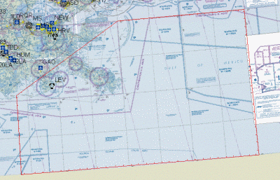
 The FAA has cordoned off a fairly
sizable chunk of the northwest Gulf of Mexico with a TFR to help
regulate the flow of traffic through the area affected by the
Deepwater Horizon oil spill. The NOTAM is in effect "until further
notice."
The FAA has cordoned off a fairly
sizable chunk of the northwest Gulf of Mexico with a TFR to help
regulate the flow of traffic through the area affected by the
Deepwater Horizon oil spill. The NOTAM is in effect "until further
notice."
The FAA says the TFR is due to the numerous low level operations
that will be associated with the oil cleanup efforts.
The TFR encompasses an area bounded by: 290500n/0904000w or the
Leeville /LEV/ VORTAC 258 degree radial at 30.1 NM to
300000n/0890000w, or the Gulfport /GPT/VORTAC 169 degree radial at
24.7 NM to 300000n/0870000w, or the Crestview /CEW/ VORTAC 196
degree radial at 52.2 NM to 280000n/0870000w, or the Panama City
/PFN/ VORTAC 208 degree radial at 149.6 NM to 280000n/0904000w, or
the Leeville /LEV/ VORTAC 201 degree radial at 76.3 NM to the point
of beginning at and below 3000 feet AGL excluding the airspace
outside of 12 nautical miles from the us coastline.
This area is also depicted on U.S. Gulf Coast VFR aeronautical
chart id helgc as an area bounded from South Pelto 2/sp02 then to
South Pass 6/sp06 then to Chandler 39/ch39 then to Pensacola
984/pe984 then to Desoto Canyon 635/dc635 to South Timbalair
242/st242 and then back to original point. All aircraft operations
are prohibited except those flights authorized by ATC, routine
flights supporting offshore oil operations; federal, state, local
and military flight operations supporting oil spill recovery and
reconstitution efforts; and air medical and law enforcement
operations.
All pilots operating within and near this area including the
shoreline should exercise extreme caution due to the numerous low
level operations associated with the Deepwater Horizon/mc-252
incident 3000 feet and below.
Aircraft involved in these operations may make sudden changes in
direction, speed, and altitude.
The incident commander has directed that aircraft participating
in the Deepwater Horizon/mc252 incident, operate at the altitudes
assigned by mission type unless otherwise directed. Oil industry
aircraft on routine support missions within the TFR area should not
operate below 1500 feet until within 2 nautical miles of their
landing platform/site and remain on their assigned mode 3a code at
all times. Participating aircraft in the recovery efforts are
required to contact Houma air operations at 985-493-7607 for
assigned work area and mode 3a beacon code assignments. Aircraft
shall squawk the assigned mode 3a beacon code at all times while
inside the TFR.
With the exception of aircraft conducting aerial chemical
dispersing operations, no fixed wing aircraft are authorized below
1000 feet above the surface unless for landing and takeoff. Pilots
are advised to check notams frequently for possible changes prior
to operating in this area.
Operations not covered by the above authorizations may be
permitted on a case-by-case basis dependent upon safety issues,
operational requirements, weather conditions, and traffic volume.
Flights authorized under this exception must be conducted under
visual flight rules. Pilots requesting flights under this exception
must contact the Houma Deepwater Horizon incident air operations
center at 985-493-7804 between the hours of 0600-1800 CST, a
minimum of 24 hours prior to desired flight time.
Operators should be prepared to provide precise details of their
requested flight including: pilots name and contact information,
company/organization, purpose of flight, type aircraft, callsign,
ingress/egress points and times, requested altitude and route of
flight. Pilots will then be provided with additional instructions
for obtaining final approval and beacon code assignment.
Pilots should be aware that flights approved under this
exception are subject to last minute change or cancellation due to
the dynamic nature of this event. Houma air operations center at
985-493-7607 is the coordination facility. For information about
this NOTAM contact the system operations support center (SOSC) at
202-267-8276.
 ANN's Daily Aero-Linx (04.15.24)

