New Avionics For The Part 27 VFR/IFR Turbine Helicopter Market
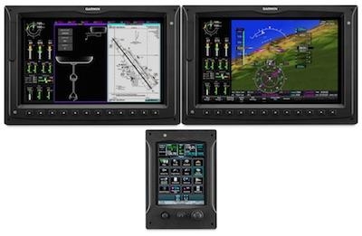
Garmin has introduced the G3000H, an IFR-capable integrated flight deck specifically designed for Part 27 turbine helicopters. The forward-fit G3000H offers a number of features, including WAAS/SBAS, ILS approach capability, VFR and IFR helicopter charts and Connext wireless integration. It’s also equipped for ADS-B In/Out, offers visual approach guidance and an HSI map. The G3000H touchscreen interface boasts superior in-flight features and benefits that reduce pilot workload, providing this class of helicopters with the best situational awareness tools available on the market today.
“The G3000H blends a superior feature set and safety-minded technology into a contemporary platform for the VFR/IFR turbine helicopter market,” said Carl Wolf, vice president of aviation marketing and sales. “With the G3000H, we’re excited to bring IFR capabilities in an advanced integrated flight deck and further expand our product offering so our partners have even more options within this class of helicopters.”
Built with a flexible and scalable architecture that can be tailored to a variety of helicopter designs, the G3000H combines widescreen, high-resolution displays with touchscreen controls that serve as the pilot interface to the integrated flight deck. The landscape-oriented displays offer immediate access to critical in-flight information in a consolidated, easy-to-read format. The G3000H also features pilot-selectable split-screen capability that allows for two or more separate pages to be displayed simultaneously, so pilots can easily access valuable decision-making information on a single screen.
The G3000H boasts additional features and optional capabilities, including:
- Helicopter synthetic vision technology (HSVT) displays an “out-of-the-window” view of surroundings on the PFD, which is particularly helpful during nighttime operations or in degraded visibility environments (DVE). HSVT seamlessly blends information related to the helicopter’s position with topographic databases to create and display real-time 3D images. HSVT also incorporates visual and audible alerting of potential ground hazards by displaying terrain, available obstacles and powerlines that may pose a threat to the helicopter.
- Hover Display provides a combination of location, heading and vector references to help guide and orient pilots during hovering maneuvers.
- Connext wireless integration enables a variety of capabilities, including the wireless transfer of databases, flight plan and GPS waypoint information from the Garmin Pilot app, as well as the sharing of traffic, weather, GPS information, back-up attitude information, text messaging, flight tracking and more with mobile devices in the cockpit.
- Telligence Voice Command aids in pilot workload reduction by using automatic speech recognition technology built within the audio system. Using intuitive phraseology, Telligence accepts hundreds of voice commands at the push of button on the cyclic. For example, pilots can simply state, “tune destination tower,” to load the nearest tower frequency into the standby comm position.
- Helicopter terrain awareness warning system (HTAWS) provides graphical and audible alerts of potential terrain and obstacle conflicts along the flight path of the helicopter. Garmin HTAWS includes forward-looking terrain avoidance (FLTA), which features five-color contouring and aural advisories to help keep pilots aware of hazardous terrain and obstacles. While descending, voice call-outs are also available in 100-foot intervals beginning at 500-feet. An additional 50-foot call-out is available with an optional radar altimeter.
- Helicopter route charts, including VFR and IFR route charts throughout eight major U.S. metropolitan areas, which includes oil drilling platforms in the Gulf of Mexico, are accessible on the MFD.
- Reduced Protection (RP) mode works in conjunction with Garmin HTAWS by minimizing nuisance alerts during low altitude helicopter operations, while continuing to provide protection from terrain and obstacles.
- WireAware wire strike avoidance technology graphically overlays powerline information within the U.S. as well as some locations in Canada and Mexico.
- HSI mapping displays an MFD-like perspective map view in the primary field of view of the pilot on the PFD to help pilots focus on instrumentation scan, enabling them to better visualize terrain, traffic, weather and more as it relates to their flight plan.
- Visual approach capability automatically generates a three-degree vertical path from the threshold of the runway down to pilot-selectable minimums.
- Terrain profile view displays a vertical cross-section view of the active flight plan on the MFD, so it’s easier to view terrain, obstacles and weather that may pose a threat throughout an entire flight.
- ADS-B In/Out is available with the G3000H and features patented TerminalTraffic, which minimizes “nuisance” alerts in the airport environment. Audible alerts of potential flight path conflicts are also available. TargetTrend relative motion technology provides pilots with a faster, more intuitive way of judging traffic trajectories and is ideal when identifying potential threats while flying in busy traffic environments.
- Power assurance check calculates and displays the information necessary to assure the engine can produce the minimum power and torque required for flight.
- Hover performance displays hover data, including IGE (in ground effect) and OGE (out of ground effect) based on current conditions, while Cruise performance automatically calculates VNE, minimum and maximum airspeeds, range and endurance.
- Data monitoring automatically stores critical flight and engine parameters on an SD card, allowing the flight crew or maintenance personnel to easily analyze and interpret trend data. The G3000H can also interface to third-party HUMS systems.
Additional features and capabilities available with the G3000H include: SiriusXM high-resolution animated weather radar imagery, on-board weather radar, radar altimeter read-out, verbal ATC-like TAS/TCAS spoken traffic alerts, European Visual Reporting Points (VRP’s) and much more. The G3000H is also NVGcompatible and is capable of displaying video input from compatible FLIR camera sources.
Garmin is also pleased to announce that the G3000H will be featured on the new Kopter SH09 helicopter, which will consist of dual landscape-oriented displays and a single touchscreen controller. The SH09 offers superior performance for hot and high operations, as well as a low noise signature in an all new, state-of-the-art helicopter design.
(Image provided with Garmin news release)
 ANN's Daily Aero-Linx (04.15.24)

