Intellicast.com Launches New iPad Application | Aero-News Network
Aero-News Network
RSS icon RSS feed
podcast icon MP3 podcast
Subscribe Aero-News e-mail Newsletter Subscribe

Airborne Unlimited -- Most Recent Daily Episodes

Episode Date

Airborne-Monday

Airborne-Tuesday

Airborne-Wednesday Airborne-Thursday

Airborne-Friday

Airborne On YouTube

Airborne-Unlimited-04.22.24

Airborne-Unlimited-04.16.24

Airborne-FlightTraining-04.17.24 Airborne-AffordableFlyers-04.18.24

Airborne-Unlimited-04.19.24

Join Us At 0900ET, Friday, 4/10, for the LIVE Morning Brief.
Watch It LIVE at
www.airborne-live.net

Tue, Dec 21, 2010

Intellicast.com Launches New iPad Application

WSI Rolls Out Advanced, Intellicast Interactive App

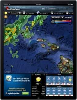
iPad users now have another free option for getting the weather delivered to the popular portable device. WSI (Weather Services International)  said Monday that Intellicast.com, its weather website, is now available as a free, downloadable, iPad application from Apple App Store.

The new iPad offering combines Intellicast.com's meteorological content with a slick user interface. The result is a mobile application that Intellicast says will keep active users ahead of the forecast with weather information for locations world-wide.
 
"Combining an array of cutting-edge weather tools, Intellicast.com's new iPad application now makes smart forecasting information available to everyone on the go," said Jim Menard, WSI's Vice President of Digital Initiatives. "Now, wherever and whenever they choose, Intellicast users can get the same high caliber of weather information they've come to expect from the Intellicast site."

 Features of the new application include:

  • NOWrad HD, the most timely high definition interactive radar for the United States
  • Blended infrared and visible high-resolution cloud imagery for North America and the surrounding waters
  • Exclusive patent pending Road Weather Index showing weather related road hazards
  • High resolution temperatures, wind speeds and snow cover
  • Real-time earthquake plotting
  • Doppler radar storm tracking which identifies severe weather cells and their likely path
  • Hurricane, typhoon and tropical cyclone tracking
  • The industry's most accurate forecasts for over 50,000 locations around the world
  • Fully integrated GPS and user defined location awareness
  • Color coded severe weather alerts from the National Weather Service

The free application is supported by advertising in the lower left corner of the screen.

FMI: www.intellicast.com

Advertisement

More News

ANN's Daily Aero-Term (04.20.24): Light Gun

Light Gun A handheld directional light signaling device which emits a brilliant narrow beam of white, green, or red light as selected by the tower controller. The color and type of>[...]

Aero-News: Quote of the Day (04.20.24)

"The journey to this achievement started nearly a decade ago when a freshly commissioned Gentry, driven by a fascination with new technologies and a desire to contribute significan>[...]

ANN's Daily Aero-Linx (04.21.24)

Aero Linx: JAARS, Inc. For decades now, we’ve landed planes on narrow rivers and towering mountains. We’ve outfitted boats and vehicles to reach villages that rarely se>[...]

Aero-News: Quote of the Day (04.21.24)

"Our driven and innovative team of military and civilian Airmen delivers combat power daily, ensuring our nation is ready today and tomorrow." Source: General Duke Richardson, AFMC>[...]

ANN's Daily Aero-Term (04.21.24): Aircraft Conflict

Aircraft Conflict Predicted conflict, within EDST of two aircraft, or between aircraft and airspace. A Red alert is used for conflicts when the predicted minimum separation is 5 na>[...]

blog comments powered by Disqus


Advertisement

Advertisement

Podcasts

Advertisement

© 2007 - 2024 Web Development & Design by Pauli Systems, LC