Twelve-Day GPS Interference Test Set For Southeast US | Aero-News Network
Aero-News Network
RSS icon RSS feed
podcast icon MP3 podcast
Subscribe Aero-News e-mail Newsletter Subscribe

Airborne Unlimited -- Most Recent Daily Episodes

Episode Date

Airborne-Monday

Airborne-Tuesday

Airborne-Wednesday Airborne-Thursday

Airborne-Friday

Airborne On YouTube

Airborne-Unlimited-04.01.24

Airborne-Unlimited-04.09.24

Airborne-Unlimited-04.10.24 Airborne-Unlimited-04.11.24

Airborne-Unlimited-04.12.24

Join Us At 0900ET, Friday, 4/10, for the LIVE Morning Brief.
Watch It LIVE at
www.airborne-live.net

Wed, Nov 30, 2011

Twelve-Day GPS Interference Test Set For Southeast US

May Result In Unreliable GPS Signals

The FAA has posted a Flight Advisory alerting pilots flying in much of the Southeast portion of the U.S. that GPS interference testing will take place for twelve days beginning December 1. The agency says the testing may result in unreliable or unavailable GPS signal.

The tests will be centered off the coast of Jacksonville, FL at 302000N/0800000W or the CRG VOR 89.9 degree radial at 78.2NM. According to the advisory, each event during the scheduled dates may last up to 45 minutes followed by 15 minutes off, and More than one event may occur during the requested times.

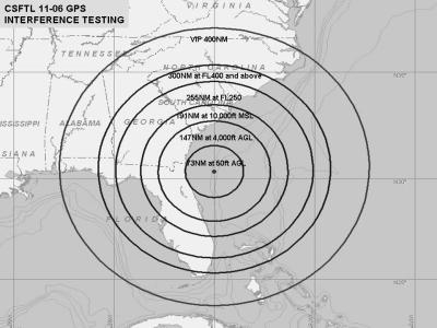
The testing is scheduled between December 1st and 12th between 2100-0245Z (1600-2145 EST). During testing, the GPS signal may be unreliable or unavailable within a 300NM circle centered at 302000N/0800000W or the CRG VOR 89.9 degree radial at 78.2NM at FL400 and above, decreasing in area with decrease in altitude to 255 NM at FL250, 191 NMR at 10,000 FT MSL, 147 NM at 4,000 FT AGL and 73 NM at 50 FT AGL.

Pilots are strongly encouraged to report anomalies during testing to the appropriate ARTCC to assist in the determination of the extent of GPS degradation during tests. The NOTAMs discussed in this advisory may change with little or no notice. Pilots are advised to check NOTAMs frequently for possible changes prior to operations in the area. NOTAMs will be published at least 24 hours in advance of any GPS tests.

FMI: www.faa.gov

Advertisement

More News

ANN's Daily Aero-Linx (04.13.24)

Aero Linx: Florida Antique Biplane Association "Biplanes.....outrageous fun since 1903." That quote really defines what the Florida Antique Biplane Association (FABA) is all about.>[...]

ANN's Daily Aero-Term (04.13.24): Beyond Visual Line Of Sight (BVLOS)

Beyond Visual Line Of Sight (BVLOS) The operation of a UAS beyond the visual capability of the flight crew members (i.e., remote pilot in command [RPIC], the person manipulating th>[...]

Airborne 04.09.24: SnF24!, Piper-DeltaHawk!, Fisher Update, Junkers

Also: ForeFlight Upgrades, Cicare USA, Vittorazi Engines, EarthX We have a number of late-breaking news highlights from the 2024 Innovation Preview... which was PACKED with real ne>[...]

Aero-News: Quote of the Day (04.14.24)

“For Montaer Aircraft it is a very prudent move to incorporate such reliable institution as Ocala Aviation, with the background of decades in training experience and aviation>[...]

ANN's Daily Aero-Term (04.14.24): Maximum Authorized Altitude

Maximum Authorized Altitude A published altitude representing the maximum usable altitude or flight level for an airspace structure or route segment. It is the highest altitude on >[...]

blog comments powered by Disqus


Advertisement

Advertisement

Podcasts

Advertisement

© 2007 - 2024 Web Development & Design by Pauli Systems, LC