Imagination TV Partners With 'Drones To The Rescue' | Aero-News Network
Aero-News Network
RSS icon RSS feed
podcast icon MP3 podcast
Subscribe Aero-News e-mail Newsletter Subscribe

Airborne Unlimited -- Most Recent Daily Episodes

Episode Date

Airborne-Monday

Airborne-Tuesday

Airborne-Wednesday Airborne-Thursday

Airborne-Friday

Airborne On YouTube

Airborne-Unlimited-04.01.24

Airborne-Unlimited-04.09.24

Airborne-Unlimited-04.10.24 Airborne-Unlimited-04.11.24

Airborne-Unlimited-04.12.24

Join Us At 0900ET, Friday, 4/10, for the LIVE Morning Brief.
Watch It LIVE at
www.airborne-live.net

Thu, Nov 27, 2014

Imagination TV Partners With 'Drones To The Rescue'

Project Launched Monday Aims To Change The Way Emergency Situations Are Handled

Imagination TV has partnered with "Drones to the Rescue" to help them gain awareness and assist in the launch of the new company starting with their Indiegogo project. The new project, named "Drones to the Rescue", launched Monday at Indiegogo.com.

The company says "Drones to the Rescue" will change the way emergency situations are handled. Drones have a unique ability to locate, assist and save victims, faster with more efficiency than any other option. The campaign mission is to provide its first product line of Search and Rescue (SAR) Drones.

"Drones to the Rescue" is combining technology to create UAVS that can reach people in small spaces and supply food, water and medicine to trapped victims. The team has created UAVs that have state-of-the-art cameras, GPS and a payloader device that isn't yet on the market. The prototype water-resistant GPS tracker is a small, lightweight, self-powered, stand-alone device that attaches to the drone and delivers real time flight data information to user's laptop, computer, or smartphone.

The GPS Tracker is a reliable solution to give you exact GPS coordinates of the device every minute, along with movement speed and direction. The device has its own SIM card and phone number. GPS tracking is also shown on Google maps map overlay. These GPS functions, paired with the camera and payloader, will create an unstoppable SAR machine.

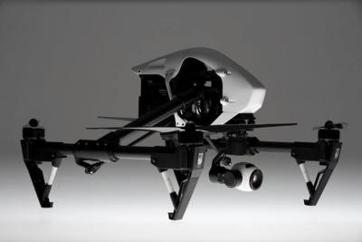
Indiegogo backers will be able to purchase the prototype as well as a long list of high demand items. They have rewards that include a Plexidrone Pro, Fe-RVJET Flying Wing, AirDog Auto Follow Drone for GoPro and even an exclusive Search and Rescue Version Drone. Also, this campaign has a referral program where people can share the campaign and win their very own Inspire 1: DJI's most advanced technology. For those who don't know, the Inspire 1 is an easy to use, all-in-one flying kit, for first time users and enthusiasts alike.

The Indiegogo campaign goal is to raise $40,000, which will cover the production costs of the components, funding of further research and expansion of the product line.

(Image from "Drones to the Rescue" Facebook page)

FMI: www.facebook.com/dronesindiegogo

Advertisement

More News

ANN's Daily Aero-Linx (04.13.24)

Aero Linx: Florida Antique Biplane Association "Biplanes.....outrageous fun since 1903." That quote really defines what the Florida Antique Biplane Association (FABA) is all about.>[...]

ANN's Daily Aero-Term (04.13.24): Beyond Visual Line Of Sight (BVLOS)

Beyond Visual Line Of Sight (BVLOS) The operation of a UAS beyond the visual capability of the flight crew members (i.e., remote pilot in command [RPIC], the person manipulating th>[...]

Airborne 04.09.24: SnF24!, Piper-DeltaHawk!, Fisher Update, Junkers

Also: ForeFlight Upgrades, Cicare USA, Vittorazi Engines, EarthX We have a number of late-breaking news highlights from the 2024 Innovation Preview... which was PACKED with real ne>[...]

Aero-News: Quote of the Day (04.14.24)

“For Montaer Aircraft it is a very prudent move to incorporate such reliable institution as Ocala Aviation, with the background of decades in training experience and aviation>[...]

ANN's Daily Aero-Term (04.14.24): Maximum Authorized Altitude

Maximum Authorized Altitude A published altitude representing the maximum usable altitude or flight level for an airspace structure or route segment. It is the highest altitude on >[...]

blog comments powered by Disqus


Advertisement

Advertisement

Podcasts

Advertisement

© 2007 - 2024 Web Development & Design by Pauli Systems, LC