NASA Views Landing Site Through Eyes Of Future Moon Crew | Aero-News Network
Aero-News Network
RSS icon RSS feed
podcast icon MP3 podcast
Subscribe Aero-News e-mail Newsletter Subscribe

Airborne Unlimited -- Most Recent Daily Episodes

Episode Date

Airborne-Monday

Airborne-Tuesday

Airborne-Wednesday Airborne-Thursday

Airborne-Friday

Airborne On YouTube

Airborne-Unlimited-04.01.24

Airborne-Unlimited-04.09.24

Airborne-Unlimited-04.10.24 Airborne-Unlimited-04.11.24

Airborne-Unlimited-04.12.24

Join Us At 0900ET, Friday, 4/10, for the LIVE Morning Brief.
Watch It LIVE at
www.airborne-live.net

Thu, Feb 28, 2008

NASA Views Landing Site Through Eyes Of Future Moon Crew

Detailed Images Show Rockier Terrain Than Anticipated

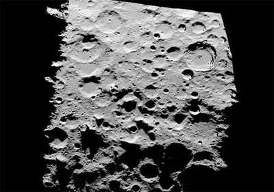
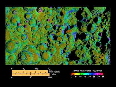
It's always wise to look before you leap... or launch. NASA has obtained the highest resolution terrain mapping to date of the moon's rugged south polar region, with a resolution to 20 meters (66 feet) per pixel. The images contained a few surprises for the space agency, that could affect a future NASA mission.

Scientists at NASA's Jet Propulsion Laboratory in Pasadena, CA collected data on the area -- considered a candidate landing site for a future manned moon mission -- using the Deep Space Network’s Goldstone Solar System Radar located in California's Mojave Desert.

The mapping data collected indicate that the region of the moon's south pole near Shackleton Crater is much more rugged than previously understood. The imagery generated by the data has been incorporated into animation depicting the descent to the lunar surface of a future human lunar lander and a flyover of Shackleton Crater.

"The south pole of the moon certainly would be a beautiful place to explore," said Doug Cooke, deputy associate administrator for the Exploration Systems Mission Directorate at NASA Headquarters, Washington. "We now know the south pole has peaks as high as Mt. McKinley and crater floors four times deeper than the Grand Canyon. There are challenges that come with such rugged terrain, and these data will be an invaluable tool for advance planning of lunar missions."

Three times during a six-month period in 2006, scientists targeted the moon's south polar region using Goldstone's 70-meter (230-foot) radar dish. The antenna, three-quarters the size of a football field, sent a 500-kilowatt-strong, 90-minute-long radar stream 373,046 kilometers (231,800 miles) to the moon. The radar bounced off the rough-hewn lunar terrain over an area measuring about 644 kilometers by 402 kilometers (400 miles by 250 miles). Signals were reflected back to two of Goldstone's 34-meter (112-foot) antennas on Earth. The roundtrip time, from the antenna to the moon and back, was about two-and-a-half seconds.

"I have not been to the moon, but this imagery is the next best thing," said Scott Hensley, a scientist at JPL and lead investigator for the study. "With these data we can see terrain features as small as a house without even leaving the office."

Previously, the best resolution of the moon's south pole was generated by the Clementine spacecraft, which could resolve lunar terrain features near the south pole at one kilometer (0.6 miles) per pixel. The new resolution generated by JPL is 50 times more detailed.

NASA's Lunar Reconnaissance Orbiter will provide the next generation of lunar imaging and data. The spacecraft is scheduled to launch in late 2008. The Lunar Reconnaissance Orbiter Camera will retrieve high-resolution images of the moon's surface and lunar poles with resolutions to 1 meter (3.3 feet).

Funding for the program was provided by NASA's Exploration Systems Mission Directorate.

FMI: www.nasa.gov/mission_pages/exploration/mmb/022708.html

Advertisement

More News

ANN's Daily Aero-Linx (04.13.24)

Aero Linx: Florida Antique Biplane Association "Biplanes.....outrageous fun since 1903." That quote really defines what the Florida Antique Biplane Association (FABA) is all about.>[...]

ANN's Daily Aero-Term (04.13.24): Beyond Visual Line Of Sight (BVLOS)

Beyond Visual Line Of Sight (BVLOS) The operation of a UAS beyond the visual capability of the flight crew members (i.e., remote pilot in command [RPIC], the person manipulating th>[...]

Airborne 04.09.24: SnF24!, Piper-DeltaHawk!, Fisher Update, Junkers

Also: ForeFlight Upgrades, Cicare USA, Vittorazi Engines, EarthX We have a number of late-breaking news highlights from the 2024 Innovation Preview... which was PACKED with real ne>[...]

Aero-News: Quote of the Day (04.14.24)

“For Montaer Aircraft it is a very prudent move to incorporate such reliable institution as Ocala Aviation, with the background of decades in training experience and aviation>[...]

ANN's Daily Aero-Term (04.14.24): Maximum Authorized Altitude

Maximum Authorized Altitude A published altitude representing the maximum usable altitude or flight level for an airspace structure or route segment. It is the highest altitude on >[...]

blog comments powered by Disqus


Advertisement

Advertisement

Podcasts

Advertisement

© 2007 - 2024 Web Development & Design by Pauli Systems, LC