Tue, Apr 19, 2011
North Dakota Wing Flying Four To Five Sorties Per Day
 With spring flooding nearing high-water marks once again in
the Red River Valley, volunteers from Civil Air Patrol's North
Dakota Wing are flying daily, using the latest in digital airborne
photography equipment to help emergency management officials assess
damages and deploy assets to the region. "We've been flying
multiple sorties - four or five flights a day - for about a week
now," said Lt. Col. William E. Kay, the wing's interim
commander.
With spring flooding nearing high-water marks once again in
the Red River Valley, volunteers from Civil Air Patrol's North
Dakota Wing are flying daily, using the latest in digital airborne
photography equipment to help emergency management officials assess
damages and deploy assets to the region. "We've been flying
multiple sorties - four or five flights a day - for about a week
now," said Lt. Col. William E. Kay, the wing's interim
commander.
CAP's aircraft provide the perfect vantage point for
reconnaissance photos, which are tagged with the date and GPS
coordinates. The photos are providing emergency response
decision-makers with the North Dakota Department of Emergency
Services, the U.S. Department of Homeland Security and the Federal
Emergency Management Agency with the latest information they need
to assess damages and deploy assets throughout the region.
The flooding in the Red River Valley is starting to peak in
Fargo, the state's largest city, Kay said, with much of the
floodwaters from a record winter snow pack and iced-over ponds and
lakes "rolling north now." The Red River flows north along the
North Dakota and Minnesota border toward Grand Forks, ultimately
reaching Lake Winnipeg in Canada.
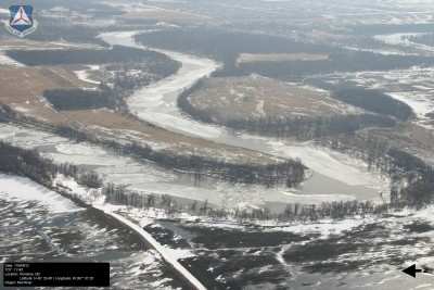
CAP Red River Aerial Photo Taken During 2010
Season
Such a mission is a ritual each spring for the North Dakota Wing
as well as other CAP wings in the upper Midwest. "We started in
earnest on March 16 and made practice flights even before that,"
Kay said. "And we've been going at it since."
In spring 2010, CAP aircraft and volunteers from seven wings
provided nearly 360 hours of flight time and delivered thousands of
photos supporting disaster relief efforts in North Dakota and
Minnesota, as well as South Dakota. The images were used to
determine the extent of flooding along the Red River and other
rivers and tributaries as they crested, as well as to help analyze
the integrity of several earthen dams. They also helped officials
improve the snow melt models used to predict water levels for the
river and its tributaries.
More News
Inversion to Launch Reentry Vehicle Demonstrator Aboard SpaceX Falcon 9 This fall, the aerospace startup Inversion is set to launch its Ray reentry demonstrator capsule aboard Spac>[...]
"We are excited to accelerate the adoption of electric aviation technology and further our journey towards a sustainable future. The agreement with magniX underscores our commitmen>[...]
"The journey to this achievement started nearly a decade ago when a freshly commissioned Gentry, driven by a fascination with new technologies and a desire to contribute significan>[...]
Aero Linx: OX5 Aviation Pioneers Each year a national reunion of OX5 Aviation Pioneers is hosted by one of the Wings in the organization. The reunions attract much attention as man>[...]
"Our driven and innovative team of military and civilian Airmen delivers combat power daily, ensuring our nation is ready today and tomorrow." Source: General Duke Richardson, AFMC>[...]
 SpaceX to Launch Inversion RAY Reentry Vehicle in Fall

